File:ClearwaterLakes.jpg
Jump to navigation
Jump to search

Size of this preview: 800 × 600 pixels. Other resolutions: 320 × 240 pixels | 640 × 480 pixels | 1,024 × 768 pixels.
Original file (1,024 × 768 pixels, file size: 415 KB, MIME type: image/jpeg)
Captions
Captions
Add a one-line explanation of what this file represents
| Description |
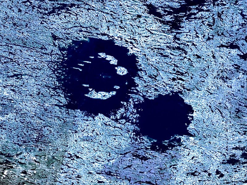
English: Clearwater Lake is a double meteoric impact crater lake in Quebec, Canada. It is 71 km long and 33 km wide.
Français : Le lac à l'Eau Claire, est un lac de cratère d'impact météorique binaire, situé dans la région administrative Nord-du-Québec, Québec, Canada. Il fait 71 km de longueur et 33 km de largeur. |
| Date | 8 January 2006 (upload date) |
| Source | Created with NASA WorldWind using Landsat 7 (Visible Color) satellite image. Vertical exaggeration 3x. |
| Author | Photograph: NASA – Upload: User:Vesta |
| Object location | | View this and other nearby images on: OpenStreetMap |
|---|
| This image is in the public domain because it is a screenshot from NASA’s globe software World Wind using a public domain layer, such as Blue Marble, MODIS, Landsat, SRTM, USGS or GLOBE.
|
 |
File history
Click on a date/time to view the file as it appeared at that time.
| Date/Time | Thumbnail | Dimensions | User | Comment | |
|---|---|---|---|---|---|
| current | 03:42, 15 February 2013 | | 1,024 × 768 (415 KB) | Sneeuwschaap (talk | contribs) | correction of brightness levels |
| 00:00, 8 January 2006 |  | 1,024 × 768 (379 KB) | Vesta~commonswiki (talk | contribs) | *'''Description:'''Clearwater Lakes double impact crater in Quebec, Canada. *'''Source:''' Created with NASA WorldWind by User:Vesta using Landsat 7 (Visible Color) satellite image. {{PD-WorldWind}} |
You cannot overwrite this file.
File usage on Commons
The following 3 pages use this file:
File usage on other wikis
The following other wikis use this file:
- Usage on arz.wikipedia.org
- Usage on bg.wikipedia.org
- Usage on ceb.wikipedia.org
- Usage on de.wikipedia.org
- Usage on eo.wikipedia.org
- Usage on es.wikipedia.org
- Usage on fr.wikipedia.org
- Usage on ru.wikipedia.org
- Usage on sv.wikipedia.org
- Usage on uk.wikipedia.org
- Usage on www.wikidata.org
- Usage on zh.wikipedia.org