File:Cliffe Cut.jpg
Salta a la navegació
Salta a la cerca
No hi ha cap versió amb una resolució més gran.
Cliffe_Cut.jpg (640 × 479 píxels, mida del fitxer: 122 Ko, tipus MIME: image/jpeg)
Llegendes
Llegendes
Afegeix una explicació d'una línia del que representa aquest fitxer
Resum
[modifica]
| Descripció |
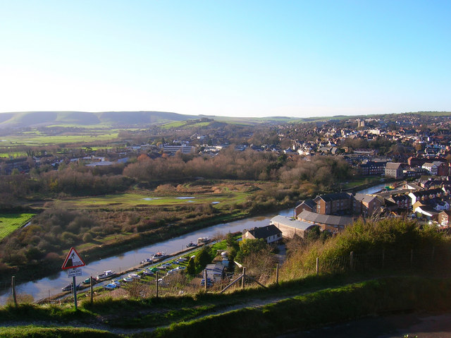
English: Cliffe Cut, River Ouse Taken from the cliff on Chapel Hill near the golf club and looking down onto the town. The stretch of river in the foreground is Cliffe Cut undertaken when the Ouse was canalised in the late 1790s. The original course of the river meandered to the east by the boathouse next to Hilman Close, the circular set of flats. Beyond the river can be seen the Heart Of Reeds which can be found 291632 along with an opposite view. It was also at this point that Britain's worst ever avalanche occurred on Christmas Eve 1836 when a 15 foot snowdrift perched on this cliff top collapsed onto houses below killing 8 people. The current Snowdrop Inn below is named after this event.
Other views which can be taken in include the castle to the right and the downs at Kingston ridge on the left hand side. |
| Data | |
| Font | From geograph.org.uk |
| Autor | Simon Carey |
| Posició de la càmera | | Aquesta i altres imatges properes a: OpenStreetMap |
|---|
Llicència
[modifica]

|
Aquesta imatge prové de la col·lecció del projecte Geograph British Isles. Vegeu la pàgina d'aquesta fotografia al lloc web Geograph per a més informació del fotògraf. El titular dels drets d'autor d'aquesta imatge és Simon Carey i autoritza utilitzar-la sota la llicència Reconeixement-CompartirIgual 2.0 de Creative Commons.
|
Aquest fitxer està publicat sota la llicència de Creative Commons Reconeixement i Compartir Igual 2.0 Genèrica.
Reconeixement: Simon Carey
- Sou lliure de:
- compartir – copiar, distribuir i comunicar públicament l'obra
- adaptar – fer-ne obres derivades
- Amb les condicions següents:
- reconeixement – Heu de donar la informació adequada sobre l'autor, proporcionar un enllaç a la llicència i indicar si s'han realitzat canvis. Podeu fer-ho amb qualsevol mitjà raonable, però de cap manera no suggereixi que l'autor us dóna suport o aprova l'ús que en feu.
- compartir igual – Si modifiqueu, transformeu, o generareu amb el material, haureu de distribuir les vostres contribucions sota una llicència similar o una de compatible com l'original
Historial del fitxer
Cliqueu una data/hora per veure el fitxer tal com era aleshores.
| Data/hora | Miniatura | Dimensions | Usuari/a | Comentari | |
|---|---|---|---|---|---|
| actual | 15:24, 9 oct 2007 | | 640 × 479 (122 Ko) | Derek Andrews (discussió | contribucions) | {{Information |Description=This tidal stretch of the River Ouse just south of Lewes is Cliffe Cut. It was made when the Ouse was canalised in the late 1790s. The original course of the river meandered in the foreground. |Source=http://www.geograph.org.uk/ |
No podeu sobreescriure aquest fitxer.
Ús del fitxer
La pàgina següent utilitza aquest fitxer:
Ús global del fitxer
Utilització d'aquest fitxer en altres wikis:
- Utilització a ca.wikipedia.org
- Utilització a en.wikipedia.org
- Utilització a fi.wikipedia.org
- Utilització a www.wikidata.org