File:Close view of curved ridges in Amazonis quadrangle 02.jpg
Jump to navigation
Jump to search
Size of this preview: 800 × 317 pixels. Other resolutions: 320 × 127 pixels | 640 × 254 pixels | 1,680 × 666 pixels.
Original file (1,680 × 666 pixels, file size: 1.1 MB, MIME type: image/jpeg)
Captions
Captions
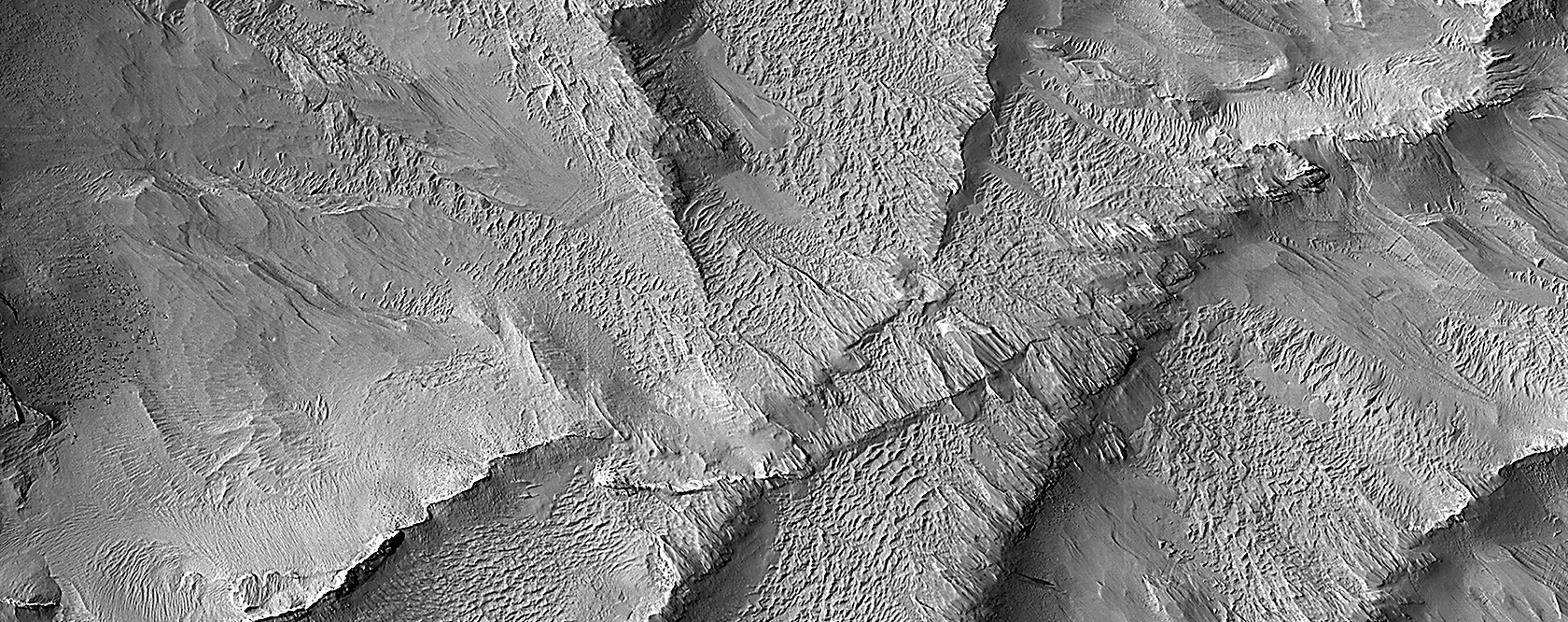
Close view of curved ridges that formed underground and then were uncovered
Summary
[edit]
| Description |
English: Curved ridges, as seen by HiRISE under HiWish program. NASA wrote the following caption for this image: This image shows a group of curved ridges in an area called Lycus Sulci, which is located near the Olympus Mons volcano. Much of the rocks in this area have been subjected to erosion (e.g., scouring and removal) by the wind, so that the surface we see today was originally buried deep underground.
Ridges such like these typically form underground through diagenesis, a process where water flows underground and minerals start to form from chemicals within the groundwater. These minerals are typically most abundant in places such as cracks, where the water can easily flow and minerals have room to grow. The mineral-filled cracks are more difficult to erode than the surrounding rocks and thus can form ridges such like these when the weaker surrounding rocks are eroded away. Written by: Chris Okubo (4 May 2023) |
| Date | |
| Source | https://www.uahirise.org/ESP_077982_1920 |
| Author | Jim Secosky suggested NASA take a picture of this spot. The image credit should read: NASA/JPL-Caltech/UArizona/. |
| Camera location | | View this and other nearby images on: OpenStreetMap |
|---|
Licensing
[edit]
| This file is in the public domain in the United States because it was solely created by NASA. NASA copyright policy states that "NASA material is not protected by copyright unless noted". (See Template:PD-USGov, NASA copyright policy page or JPL Image Use Policy.) | ||
 |
Warnings:
|
File history
Click on a date/time to view the file as it appeared at that time.
| Date/Time | Thumbnail | Dimensions | User | Comment | |
|---|---|---|---|---|---|
| current | 13:31, 17 November 2023 | 1,680 × 666 (1.1 MB) | Jimmarsmars (talk | contribs) | Uploaded a work by Jim Secosky suggested NASA take a picture of this spot. The image credit should read: NASA/JPL-Caltech/UArizona/. from https://www.uahirise.org/ESP_077982_1920 with UploadWizard |
You cannot overwrite this file.
File usage on Commons
There are no pages that use this file.
File usage on other wikis
The following other wikis use this file:
- Usage on en.wikipedia.org