File:Coastal Landslides of an earthquake-triggered landslide on south coast of Haiti near village of Nan Diamant as a result of the M7 earthquake that struck Haiti in 2010.jpg
Jump to navigation
Jump to search
Size of this preview: 800 × 533 pixels. Other resolutions: 320 × 213 pixels | 640 × 427 pixels | 1,024 × 683 pixels | 1,200 × 800 pixels.
Original file (1,200 × 800 pixels, file size: 556 KB, MIME type: image/jpeg)
Captions
Captions
Add a one-line explanation of what this file represents
Summary[edit]
| Description |
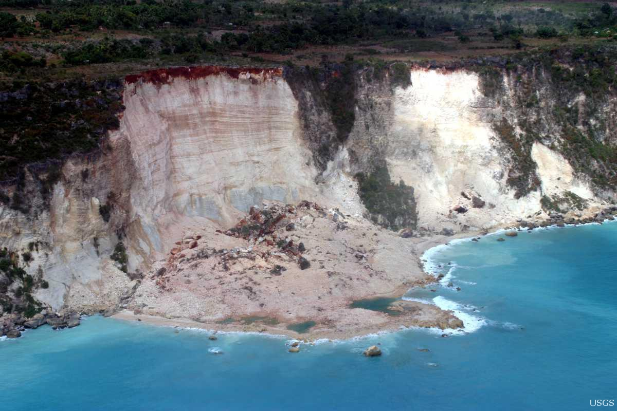
English: A shot of an earthquake-triggered landslide on south coast of Haiti near village of Nan Diamant as a result of the M7.0 earthquake that struck Haiti in 2010. According to official estimates, the Jan. 12 earthquake in Haiti injured 300,000 people, displaced 1.3 million, and left 97,294 houses destroyed and 188,383 damaged in Port-au-Prince and much of southern Haiti. This large, shallow earthquake produced violent shaking in Léogâne, west of Port-au-Prince. This shaking level can cause damage even to well-built buildings anywhere in the world.
Photo credit: Randy Jibson, USGS. |
| Date | |
| Source | https://www.flickr.com/photos/27784370@N05/14940813327/ |
| Author | U.S. Geological Survey |
Licensing[edit]
| This file is made available under the Creative Commons CC0 1.0 Universal Public Domain Dedication. | |
| The person who associated a work with this deed has dedicated the work to the public domain by waiving all of their rights to the work worldwide under copyright law, including all related and neighboring rights, to the extent allowed by law. You can copy, modify, distribute and perform the work, even for commercial purposes, all without asking permission.
|
| This image was originally posted to Flickr by U.S. Geological Survey at https://flickr.com/photos/27784370@N05/14940813327. It was reviewed on 19 January 2022 by FlickreviewR 2 and was confirmed to be licensed under the terms of the cc-zero. |
File history
Click on a date/time to view the file as it appeared at that time.
| Date/Time | Thumbnail | Dimensions | User | Comment | |
|---|---|---|---|---|---|
| current | 01:41, 19 January 2022 | | 1,200 × 800 (556 KB) | Ooligan (talk | contribs) | Uploaded a work by U.S. Geological Survey from https://www.flickr.com/photos/27784370@N05/14940813327/ with UploadWizard |
You cannot overwrite this file.
File usage on Commons
There are no pages that use this file.