File:Coastal erosion threatens the North Frisian Islands.jpg

Original file (3,820 × 2,559 pixels, file size: 4.58 MB, MIME type: image/jpeg)
Captions
Captions
Summary[edit]
| Description |
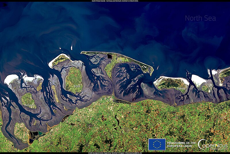
English: This image, acquired by one of the Copernicus Sentinel-2 satellites on 8 March 2022, shows the North Frisian Islands, an archipelago located between Germany and Denmark, in the North Sea. Between the Sylt Island and the mainland, lies the Wadden Sea. This area, together with the mudflats that are exposed during low tides, is part of the Schleswig-Holstein Wadden Sea National Park. The area is home to a unique biodiversity and is for this reason it has been made into a protected nature reserve part of the Natura2000 network. The mudflats are particularly important for bird migration, as they attract around 12 million specimen each year and constitutes the primary winter habitat of 34 different bird species. The North Frisian Islands, and especially the Sylt Island, are threatened by an erosion process that is rapidly damaging their environment and threatening their biodiversity. The Copernicus Marine Environment Monitoring Service (CMEMS) and the Copernicus Land Monitoring Service (CLMS) work closely together on a comprehensive coastal monitoring service able to address the complex dynamics of coastal erosion. |
| Date | Taken on 8 March 2022 |
| Source | Coastal erosion threatens the North Frisian Islands |
| Author | European Union, Copernicus Sentinel-2 imagery |
Licensing[edit]

|
This image contains data from a satellite in the Copernicus Programme, such as Sentinel-1, Sentinel-2 or Sentinel-3. Attribution is required when using this image.
Attribution: Contains modified Copernicus Sentinel data 2022
The use of Copernicus Sentinel Data is regulated under EU law (Commission Delegated Regulation (EU) No 1159/2013 and Regulation (EU) No 377/2014). Relevant excerpts:
Free access shall be given to GMES dedicated data [...] made available through GMES dissemination platforms [...].
Access to GMES dedicated data [...] shall be given for the purpose of the following use in so far as it is lawful:
GMES dedicated data [...] may be used worldwide without limitations in time.
GMES dedicated data and GMES service information are provided to users without any express or implied warranty, including as regards quality and suitability for any purpose. |
File history
Click on a date/time to view the file as it appeared at that time.
| Date/Time | Thumbnail | Dimensions | User | Comment | |
|---|---|---|---|---|---|
| current | 21:15, 31 August 2023 | | 3,820 × 2,559 (4.58 MB) | OptimusPrimeBot (talk | contribs) | #Spacemedia - Upload of https://www.copernicus.eu/system/files/2022-03/image_day/20220310_NorthFrisianIslands.jpg via Commons:Spacemedia |
You cannot overwrite this file.
File usage on Commons
There are no pages that use this file.