File:Cologne War 1.svg
跳至導覽
跳至搜尋

此 SVG 檔案的 PNG 預覽的大小:523 × 599 像素。 其他解析度:209 × 240 像素 | 419 × 480 像素 | 670 × 768 像素 | 894 × 1,024 像素 | 1,787 × 2,048 像素 | 2,448 × 2,805 像素。
原始檔案 (SVG 檔案,表面大小:2,448 × 2,805 像素,檔案大小:260 KB)
說明
說明
添加單行說明來描述出檔案所代表的內容
摘要
[編輯]
| 描述 |
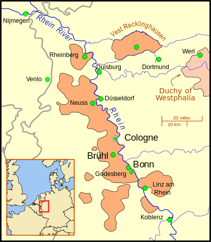
Deutsch: Karte von Kurköln mit den wichtigsten Städten des Kurfürstentums (Köln, Brühl, Bonn) sowie anderen Städten, die eine Rolle im truchsessischen Krieg spielten oder in der näheren Umgebung liegen.
Der Umriss des Kurfürstentums beruht auf der Karte von Willem and Joan Blaeu aus dem Jahre 1645 File:Blaeu 1645 - Coloniensis Archiepiscopatus.jpg Die grauen Linien zeigen die heutigen Landesgrenzen. Mit Ausnahme der Emscher sind alle Flüsse in ihrem heutigen Verlauf gezeigt. Die Karte verwendet eine Mercator-Projektion.English: A map of the Electorate of Cologne showing major cities of the Electorate (Cologne, Bruhl, Bonn) as well as towns involved in the War and other important cities in the area.
The gray lines show modern day national borders. Except for the Emscher river, the rivers are shown in their modern routes/channels/paths. This map uses a Mercator projection. |
| 日期 | |
| 來源 |
個人作品,使用:
|
| 作者 | MapMaster |
| 其他版本 | A locator map (i.e. without text) can be found at File:Archbishopric of Cologne Locator Map 1.svg |
授權條款
[編輯]
我,本作品的著作權持有者,決定用以下授權條款發佈本作品:
此檔案採用創用CC 姓名標示 3.0 未在地化版本授權條款。
- 您可以自由:
- 分享 – 複製、發佈和傳播本作品
- 重新修改 – 創作演繹作品
- 惟需遵照下列條件:
- 姓名標示 – 您必須指名出正確的製作者,和提供授權條款的連結,以及表示是否有對內容上做出變更。您可以用任何合理的方式來行動,但不得以任何方式表明授權條款是對您許可或是由您所使用。
檔案歷史
點選日期/時間以檢視該時間的檔案版本。
| 日期/時間 | 縮圖 | 尺寸 | 用戶 | 備註 | |
|---|---|---|---|---|---|
| 目前 | 2009年10月12日 (一) 03:06 | | 2,448 × 2,805(260 KB) | MapMaster(對話 | 貢獻) | Minor improvements |
| 2009年10月6日 (二) 12:45 |  | 2,448 × 2,805(260 KB) | MapMaster(對話 | 貢獻) | Added Nijmegen, Westphalia, and better background | |
| 2009年10月5日 (一) 17:40 |  | 2,448 × 2,805(247 KB) | MapMaster(對話 | 貢獻) | {{Information |Description={{en|1=A map of the Electorate of Cologne showing major cities of the Electorate (Cologne, Bruhl, Bonn) as well as towns involved in the War and other important cities in the area. }} |Source={{own}} |Author=[[User:MapMaster|Ma |
無法覆蓋此檔案。
檔案用途
下列2個頁面有用到此檔案:
全域檔案使用狀況
以下其他 wiki 使用了這個檔案:
- en.wikipedia.org 的使用狀況
- eo.wikipedia.org 的使用狀況
- es.wikipedia.org 的使用狀況
- it.wikipedia.org 的使用狀況
- no.wikipedia.org 的使用狀況
- pt.wikipedia.org 的使用狀況
- ru.wikipedia.org 的使用狀況
- sl.wikipedia.org 的使用狀況
- www.wikidata.org 的使用狀況
- zh.wikipedia.org 的使用狀況