File:Colonisation 1822.png

Исходный файл (1425 × 625 пкс, размер файла: 21 КБ, MIME-тип: image/png)
Краткие подписи
Краткие подписи
| Описание |
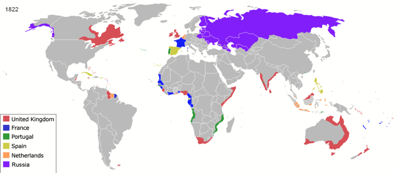
Map of major world powers by year, derived from public domain animated map on wikipedia.
As the orriginal licence of the animation was Public Domain, this image which has been derived from it is too:
|
||||||||||||||||||
| Дата | |||||||||||||||||||
| Источник | public domain animated map by ArdadN here | ||||||||||||||||||
| Автор | ArdadN | ||||||||||||||||||
.jpg)
._LOC_2001620596.jpg)

|
Это изображение неизвестного типа «historical map» желательно воссоздать или аккуратно преобразовать в векторный формат SVG. Это даёт несколько преимуществ, прочитать о которых подробнее вы можете на странице Commons:Media for cleanup. Если вам уже сейчас доступна векторная версия данного изображения, загрузите её, пожалуйста, а затем замените этот шаблон на следующий: {{Vector version available|Имя загруженного файла.svg}}.
|
| Аннотации | Это изображение аннотировано: Просмотреть аннотации на Викискладе |
История файла
Нажмите на дату/время, чтобы увидеть версию файла от того времени.
| Дата/время | Миниатюра | Размеры | Участник | Примечание | |
|---|---|---|---|---|---|
| текущий | 23:57, 17 марта 2022 | | 1425 × 625 (21 КБ) | M.Bitton (обсуждение | вклад) | per https://commons.wikimedia.org/w/index.php?title=Commons:Graphic_Lab/Map_workshop&oldid=640501111#Wrong_borders |
| 12:31, 4 апреля 2020 |  | 1425 × 625 (48 КБ) | Ориенталист (обсуждение | вклад) | Azerbaijan was part of Russia since 1813 | |
| 12:13, 4 апреля 2020 |  | 1425 × 625 (48 КБ) | Devlet Geray (обсуждение | вклад) | Cherkesses, Chechens, and Dagistani peoples weren't in Russia untill the end of Caucasus War | |
| 05:56, 29 марта 2015 |  | 1425 × 625 (53 КБ) | Alvin Lee (обсуждение | вклад) | Madagascar. See discussion. | |
| 00:32, 3 августа 2014 |  | 1425 × 625 (53 КБ) | Alvin Lee (обсуждение | вклад) | Correcting the boundary of Russia and China | |
| 21:44, 23 января 2011 |  | 1425 × 625 (77 КБ) | Micsha~commonswiki (обсуждение | вклад) | Reverted to version as of 01:41, 22 May 2010 | |
| 21:43, 23 января 2011 |  | 488 × 313 (66 КБ) | Micsha~commonswiki (обсуждение | вклад) | Africa only; includes map key | |
| 01:41, 22 мая 2010 |  | 1425 × 625 (77 КБ) | Kieran4 (обсуждение | вклад) | Louisiana Purchase | |
| 02:06, 3 мая 2010 |  | 1425 × 625 (77 КБ) | Kieran4 (обсуждение | вклад) | Corrected Dutch East Indies | |
| 10:41, 22 марта 2007 |  | 1425 × 625 (66 КБ) | Roke~commonswiki (обсуждение | вклад) | {{Information |Description=Map of major world powers by year, derived from public domain animated map on wikipedia. {{Maps of world history}} As the orriginal licence of the animation was Public Domain, this image which has been derived from it is too: { |
Вы не можете перезаписать этот файл.
Использование файла
Следующие 3 страницы используют этот файл:
Глобальное использование файла
Данный файл используется в следующих вики:
- Использование в ba.wikipedia.org
- Использование в de.wikipedia.org
- Использование в en.wikipedia.org
- Использование в es.wikipedia.org
- Использование в fa.wikipedia.org
- Использование в fr.wikipedia.org
- Использование в it.wikipedia.org
- Использование в oc.wikipedia.org
- Использование в pt.wikipedia.org
- Использование в ro.wikipedia.org
- Использование в ru.wikipedia.org