File:Colonisation 1822.png

原始文件 (1,425 × 625像素,文件大小:21 KB,MIME类型:image/png)
说明
说明
| 描述 |
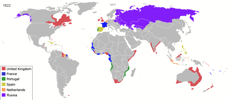
Map of major world powers by year, derived from public domain animated map on wikipedia.
As the orriginal licence of the animation was Public Domain, this image which has been derived from it is too:
|
||||||||||||||||||
| 日期 | |||||||||||||||||||
| 来源 | public domain animated map by ArdadN here | ||||||||||||||||||
| 作者 | ArdadN | ||||||||||||||||||
.jpg)
._LOC_2001620596.jpg)

|
此historical map图片可使用矢量图形重新创建为SVG文件。这具有很多好处;更多信息请参见共享资源:待清理媒体。如果存在此图片的SVG格式,请将其上传,然后将此模板替换为
{{vector version available|新图片名称}}。
建议您将SVG命名为“Colonisation 1822.svg”,这样在使用Vector version available(或Vva)模板时就不需要填写新图片名称参数。 |
| 注解 | 该图片含有注解:在维基媒体共享资源上查看注解 |
文件历史
点击某个日期/时间查看对应时刻的文件。
| 日期/时间 | 缩略图 | 大小 | 用户 | 备注 | |
|---|---|---|---|---|---|
| 当前 | 2022年3月17日 (四) 23:57 | | 1,425 × 625(21 KB) | M.Bitton(留言 | 贡献) | per https://commons.wikimedia.org/w/index.php?title=Commons:Graphic_Lab/Map_workshop&oldid=640501111#Wrong_borders |
| 2020年4月4日 (六) 12:31 |  | 1,425 × 625(48 KB) | Ориенталист(留言 | 贡献) | Azerbaijan was part of Russia since 1813 | |
| 2020年4月4日 (六) 12:13 |  | 1,425 × 625(48 KB) | Devlet Geray(留言 | 贡献) | Cherkesses, Chechens, and Dagistani peoples weren't in Russia untill the end of Caucasus War | |
| 2015年3月29日 (日) 05:56 |  | 1,425 × 625(53 KB) | Alvin Lee(留言 | 贡献) | Madagascar. See discussion. | |
| 2014年8月3日 (日) 00:32 |  | 1,425 × 625(53 KB) | Alvin Lee(留言 | 贡献) | Correcting the boundary of Russia and China | |
| 2011年1月23日 (日) 21:44 |  | 1,425 × 625(77 KB) | Micsha~commonswiki(留言 | 贡献) | Reverted to version as of 01:41, 22 May 2010 | |
| 2011年1月23日 (日) 21:43 |  | 488 × 313(66 KB) | Micsha~commonswiki(留言 | 贡献) | Africa only; includes map key | |
| 2010年5月22日 (六) 01:41 |  | 1,425 × 625(77 KB) | Kieran4(留言 | 贡献) | Louisiana Purchase | |
| 2010年5月3日 (一) 02:06 |  | 1,425 × 625(77 KB) | Kieran4(留言 | 贡献) | Corrected Dutch East Indies | |
| 2007年3月22日 (四) 10:41 |  | 1,425 × 625(66 KB) | Roke~commonswiki(留言 | 贡献) | {{Information |Description=Map of major world powers by year, derived from public domain animated map on wikipedia. {{Maps of world history}} As the orriginal licence of the animation was Public Domain, this image which has been derived from it is too: { |
您不可以覆盖此文件。
文件用途
以下3个页面使用本文件:
全域文件用途
以下其他wiki使用此文件:
- ba.wikipedia.org上的用途
- de.wikipedia.org上的用途
- en.wikipedia.org上的用途
- es.wikipedia.org上的用途
- fa.wikipedia.org上的用途
- fr.wikipedia.org上的用途
- it.wikipedia.org上的用途
- oc.wikipedia.org上的用途
- pt.wikipedia.org上的用途
- ro.wikipedia.org上的用途
- ru.wikipedia.org上的用途