File:Comarca of Rome Location.svg
Jump to navigation
Jump to search

Size of this PNG preview of this SVG file: 533 × 600 pixels. Other resolutions: 213 × 240 pixels | 427 × 480 pixels | 683 × 768 pixels | 910 × 1,024 pixels | 1,820 × 2,048 pixels | 960 × 1,080 pixels.
Original file (SVG file, nominally 960 × 1,080 pixels, file size: 647 KB)
Captions
Captions
Add a one-line explanation of what this file represents
Summary[edit]
| Description |
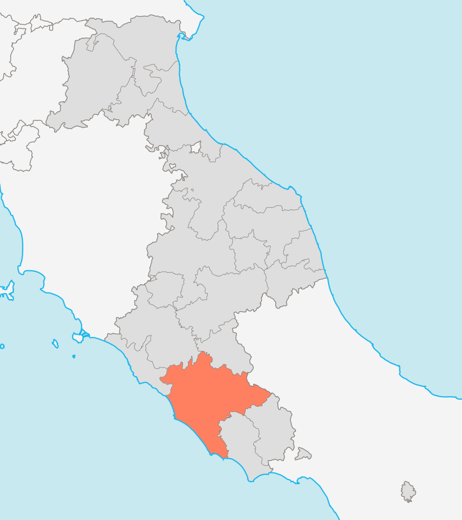
English: Locator map for the Comarca of Rome in the Papal States (1833)
Italiano: Mappa di localizzazione della Comarca di Roma nello Stato Pontificio (1833) |
| Date | |
| Source |
English: Derivative work from OpenStreetMap, released with CC-BY-SA-2.0 license Data source [1][2][3] Italiano: Opera derivata dalle mappe di OpenStreetMap rilasciate con licenza CC-BY-SA-2.0 Fonte dei dati [4][5][6] |
| Author | Erinaceus |
![[2]](http://www.igmi.org/cgi-bin/igm_labeler?image=/bigdata/immagini_antiche/biblioteca/b0007500.jpg)
![[3]](http://www.trippini.it/dbimages/9331.JPG)
This W3C-unspecified vector image was created with Inkscape .
Licensing[edit]
I, the copyright holder of this work, hereby publish it under the following licenses:

|
Permission is granted to copy, distribute and/or modify this document under the terms of the GNU Free Documentation License, Version 1.2 or any later version published by the Free Software Foundation; with no Invariant Sections, no Front-Cover Texts, and no Back-Cover Texts. A copy of the license is included in the section entitled GNU Free Documentation License. |
This file is licensed under the Creative Commons Attribution-Share Alike 3.0 Unported license.
- You are free:
- to share – to copy, distribute and transmit the work
- to remix – to adapt the work
- Under the following conditions:
- attribution – You must give appropriate credit, provide a link to the license, and indicate if changes were made. You may do so in any reasonable manner, but not in any way that suggests the licensor endorses you or your use.
- share alike – If you remix, transform, or build upon the material, you must distribute your contributions under the same or compatible license as the original.
You may select the license of your choice.
File history
Click on a date/time to view the file as it appeared at that time.
| Date/Time | Thumbnail | Dimensions | User | Comment | |
|---|---|---|---|---|---|
| current | 13:21, 26 January 2016 | | 960 × 1,080 (647 KB) | Mess (talk | contribs) | reset San Marino in white |
| 10:06, 10 June 2011 |  | 960 × 1,080 (646 KB) | Actormusicus (talk | contribs) | adjustment based on new sources | |
| 13:17, 21 March 2010 |  | 960 × 1,080 (641 KB) | Actormusicus (talk | contribs) | see File:Delegazione di Velletri.svg | |
| 20:44, 9 March 2010 |  | 960 × 1,080 (643 KB) | Actormusicus (talk | contribs) | as suggested I add the surrounding States and adjust the colors | |
| 20:48, 30 January 2010 |  | 772 × 1,013 (506 KB) | Actormusicus (talk | contribs) | adjusting Ascoli and Benevento | |
| 11:35, 29 January 2010 |  | 767 × 1,015 (535 KB) | Actormusicus (talk | contribs) | adjusting borders | |
| 20:56, 22 January 2010 |  | 767 × 1,015 (529 KB) | Actormusicus (talk | contribs) | Adding comune of Mortano | |
| 11:16, 18 January 2010 |  | 767 × 1,015 (527 KB) | Actormusicus (talk | contribs) | adjusting border Perugia-Spoleto | |
| 16:05, 6 January 2010 |  | 767 × 1,015 (507 KB) | Actormusicus (talk | contribs) | better color | |
| 12:03, 3 January 2010 |  | 767 × 1,015 (507 KB) | Actormusicus (talk | contribs) | {{Information |Description={{en|1=Locator map for the Comarca of Rome in the Papal States (1833)}} {{it|1=Mappa di localizzazione della Comarca di Roma nello Stato Pontificio (1833)}} |Source={{en|Derivative work from [http://www.openstreetmap.org/ OpenSt |
You cannot overwrite this file.
File usage on Commons
The following page uses this file:
File usage on other wikis
The following other wikis use this file:
- Usage on es.wikipedia.org
- Usage on fr.wikipedia.org
- Usage on it.wikipedia.org