File:Commonwealth of Nations.svg
Siirry navigaatioon
Siirry hakuun

Tämän PNG-esikatselun koko koskien SVG-tiedostoa: 800 × 406 kuvapistettä. Muut resoluutiot: 320 × 162 kuvapistettä | 640 × 325 kuvapistettä | 1 024 × 520 kuvapistettä | 1 280 × 650 kuvapistettä | 2 560 × 1 300 kuvapistettä | 2 754 × 1 398 kuvapistettä.
Alkuperäinen tiedosto (SVG-tiedosto; oletustarkkuus 2 754 × 1 398 kuvapistettä; tiedostokoko 1,1 MiB)
Kuvatekstit
Kuvatekstit
Lisää yhden rivin pituinen kuvaus tästä tiedostosta
Commonwealth of Nations
Yhteenveto[muokkaa]
| Kuvaus |
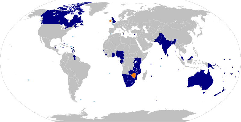
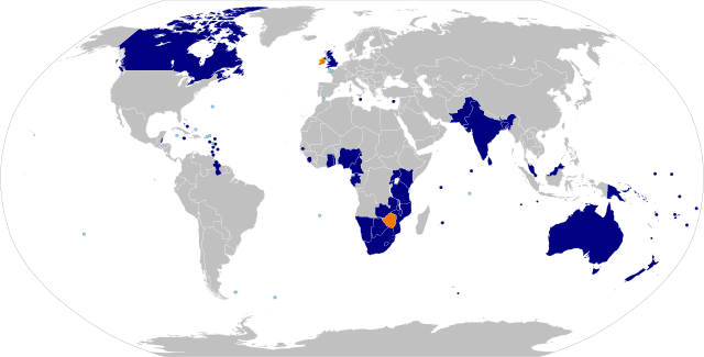
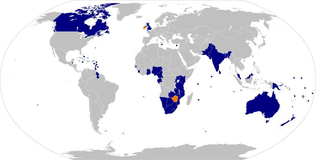
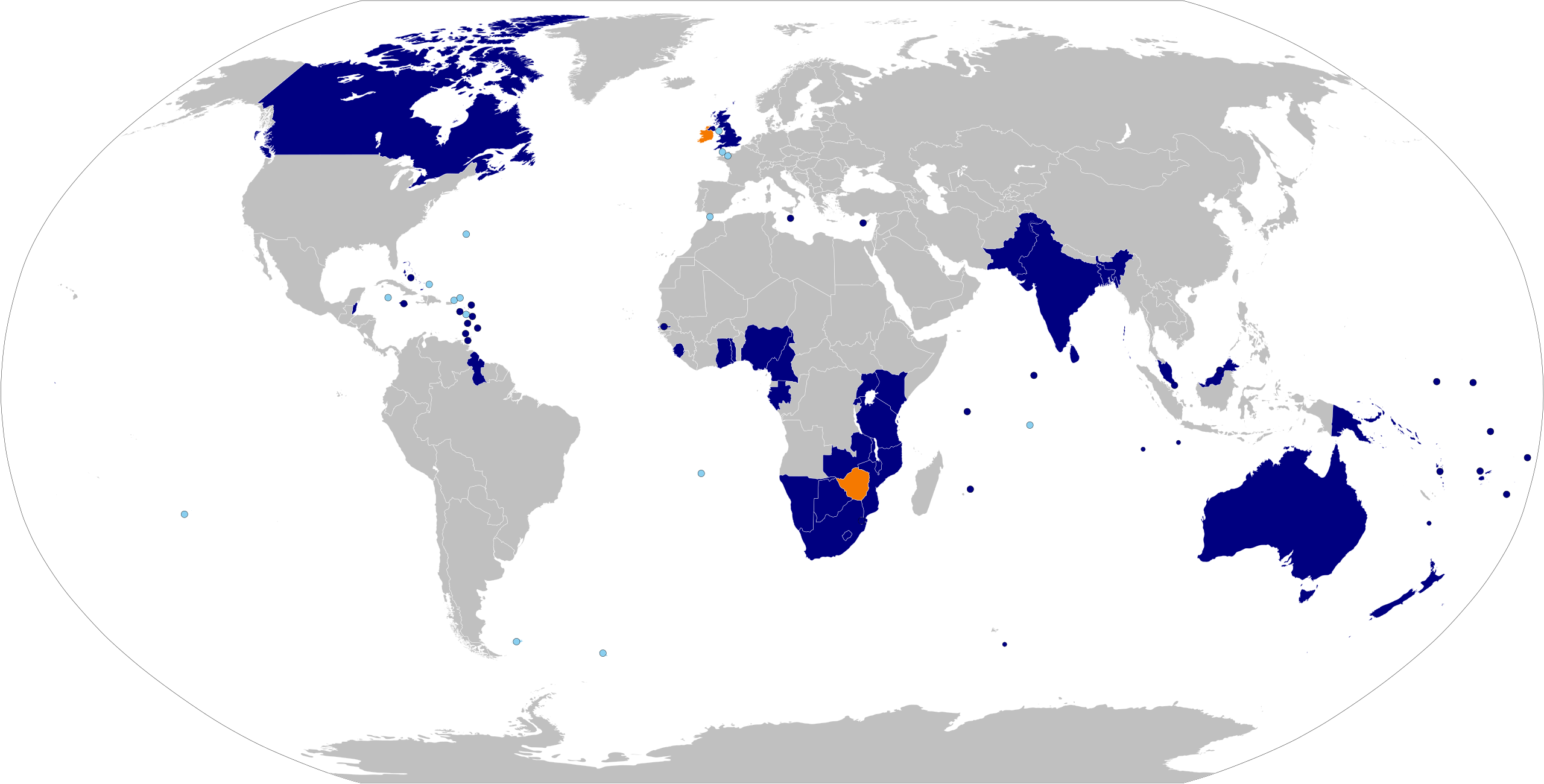
English: Map of the Commonwealth of nations. Based on Image:BlankMap-World6, compact.svg with information from List of members of the Commonwealth of Nations and colour scheme from Image:Commonwealth of Nations.png.
English (en): Commonwealth of Nations
Commonwealth of Nations members Suspended Commonwealth of Nations members (none) British Overseas Territories and Crown Dependencies
Español: Mapa de la Mancomunidad de Naciones. Basado en Image:BlankMap-World6, compact.svg con información de Países miembros de la Mancomunidad de Naciones y esquema de color de Image:Commonwealth of Nations.png.
español (es): Mancomunidad de Naciones
Miembros de la Mancomunidad de Naciones miembros suspendidos (ninguno) Territorios Británicos de Ultramar y Dependencias de la Corona Británica
Deutsch: Karte des Commonwealth of Nations. Basierend auf Image:BlankMap-World6, compact.svg mit Informationen der List of members of the Commonwealth of Nations in der englischsprachigen Wikipedia und dem Farbschema aus Image:Commonwealth of Nations.png.
Deutsch (de): Commonwealth of Nations
Mitglieder des Commonwealth of Nations Suspendierte Mitglieder
Français : Carte du Commonwealth of Nations. Basée sur Image:BlankMap-World6, compact.svg avec des informations de List of members of the Commonwealth of Nations et schéma de couleur de Image:Commonwealth of Nations.png.
français (fr): Commonwealth of Nations
Membres du Commonwealth of Nations Membres suspendus (aucun actuellement)
Hrvatski: Karta država Zajednice naroda. Temelji se na Image:BlankMap-World6, compact.svg i podacima iz Popisa članica Zajednice naroda i paleti boja iz Image:Commonwealth of Nations.png.
hrvatski (hr): Zajednica naroda
Članice Zajednice naroda Suspendirane članice Zajednice naroda Bivše članice Zajednice naroda
Português: Mapa da Commonwealth. Baseado em Image:BlankMap-World6, compact.svg com informação de List of members of the Commonwealth of Nations e esquema de cores de Image:Commonwealth of Nations.png.
português (pt): Comunidade das Nações
Membros Membros Suspensos Territórios Britânicos Ultramarinos e Dependências da Coroa Britânica
Українська: Карта Співдружності націй. Базується на Image:BlankMap-World6, compact.svg з інформацією з List of members of the Commonwealth of Nations та схемою кольорів із Image:Commonwealth of Nations.png.
українська (uk): Співдружність націй
Члени Співдружності націй Призупинені члени Колишні члени Британські заморські території та Коронні володіння
اردو: اقوام دولت مشترکہ کا نقشہ۔ اس نقشہ کا مأخذ File:BlankMap-World6, compact.svg ہے، اس میں ملکوں کی دولت مشترکہ میں رکنیت کا مشمول ڈیٹا، انگریزی ویکی پیڈیا کے مقالہ، Member states of the Commonwealth of Nations (دولت مشترکہ کے رکن ممالک) سے حاصل کیا گیا ہے اور اس کی رنگ بندی File:Commonwealth of Nations.png کے طرز پہ کی گئی ہے۔
اردو (ur): اقوام دولت مشترکہ
ارکان دولت مشترکہ دولت مشترکہ کے معطل ارکان دولت مشترکہ کے سابقہ ارکان سمندر پار برطانوی سرزمین اور غیر آزاد، برطانوی تاج کی ممتلک ریاستیں
|
| Päiväys | (UTC) |
| Lähde | Oma teos, sources given at Member states of the Commonwealth of Nations |
| Tekijä | Applysense |
| Käyttöoikeus (Tämän tiedoston uudelleenkäyttö) |
Public domain. |
Lisenssi[muokkaa]
| Minä, tämän teoksen tekijänoikeudellinen omistaja, julkaisen tämän teoksen public domainiin eli luovun kaikista tekijänoikeuksista lain sallimissa puitteissa. Tämä on voimassa maailmanlaajuisesti. Joissain maissa laki ei mahdollista tätä. Mikäli näin on: Myönnän kenelle tahansa oikeuden käyttää tätä teosta mihin tahansa tarkoitukseen, ilman mitään ehtoja, ellei laki vaadi ehtojen asettamista. |
Tiedoston historia
Päiväystä napsauttamalla näet, millainen tiedosto oli kyseisellä hetkellä.
| Päiväys | Pienoiskuva | Koko | Käyttäjä | Kommentti | |
|---|---|---|---|---|---|
| nykyinen | 25. kesäkuuta 2022 kello 19.16 | | 2 754 × 1 398 (1,1 MiB) | DrKay (keskustelu | muokkaukset) | added Gabon and Togo |
| 24. tammikuuta 2022 kello 12.21 |  | 2 754 × 1 398 (1,05 MiB) | Saftorangen (keskustelu | muokkaukset) | Rebase map on BlankMap-World.svg. Add GS and IO as overseas territories (teal) | |
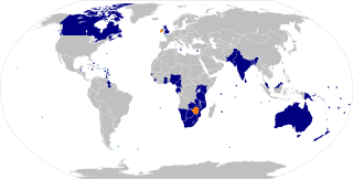
| 2. helmikuuta 2020 kello 19.19 |  | 940 × 477 (1,34 MiB) | MapleCenturion (keskustelu | muokkaukset) | Changed Maldives to Current Member (Rejoined the Commonwealth) | |
| 29. huhtikuuta 2018 kello 07.32 |  | 940 × 477 (1,34 MiB) | DrKay (keskustelu | muokkaukset) | Amend Gambia | |
| 16. lokakuuta 2016 kello 01.48 |  | 940 × 477 (1,26 MiB) | फ़िलप्रो (keskustelu | muokkaukset) | updated Maldives | |
| 2. heinäkuuta 2015 kello 21.12 |  | 940 × 477 (1,64 MiB) | DrKay (keskustelu | muokkaukset) | correct French Polynesia to Pitcairn per talk | |
| 9. lokakuuta 2014 kello 10.06 |  | 940 × 477 (1,64 MiB) | Chipmunkdavis (keskustelu | muokkaukset) | Fiji now a full member again. | |
| 3. lokakuuta 2013 kello 21.26 |  | 940 × 477 (1,64 MiB) | Treehill (keskustelu | muokkaukset) | Gambia leaved the Commonwealth today. | |
| 27. joulukuuta 2011 kello 19.45 |  | 940 × 477 (1,64 MiB) | Bastin (keskustelu | muokkaukset) | This map is supposed to illustrate the Commonwealth's members and ex-members. Use your own map. | |
| 21. joulukuuta 2011 kello 15.09 |  | 940 × 477 (1,25 MiB) | NikNaks (keskustelu | muokkaukset) | Added red colour for prospective members, as per request on COM:GL/I |
Et voi tallentaa uutta tiedostoa tämän tilalle.
Tiedoston käyttö
Seuraavat 2 sivua käyttävät tätä tiedostoa:
Tiedoston järjestelmänlaajuinen käyttö
Seuraavat muut wikit käyttävät tätä tiedostoa:
- Käyttö kohteessa af.wikipedia.org
- Käyttö kohteessa als.wikipedia.org
- Käyttö kohteessa ang.wikipedia.org
- Käyttö kohteessa ar.wikipedia.org
- Käyttö kohteessa arz.wikipedia.org
- Käyttö kohteessa az.wikipedia.org
- Käyttö kohteessa ba.wikipedia.org
- Käyttö kohteessa be.wikipedia.org
- Käyttö kohteessa bn.wikipedia.org
- Käyttö kohteessa ckb.wikipedia.org
- Käyttö kohteessa cs.wikipedia.org
- Käyttö kohteessa de.wikipedia.org
- Käyttö kohteessa dsb.wikipedia.org
- Käyttö kohteessa en.wikipedia.org
- English in the Commonwealth of Nations
- Talk:English in the Commonwealth of Nations
- Foreign relations of the United Kingdom
- Talk:Westminster system
- Talk:Responsible government
- Talk:Monarchy of the United Kingdom
- Talk:Received Pronunciation
- Talk:Judicial Committee of the Privy Council
- Talk:Governor General of Canada
- Talk:Netball
- Talk:Elizabeth II
- Talk:Northern Territory
- Talk:Royal assent
- Talk:Commonwealth of Nations
- Talk:British royal family
- Talk:Queensland
- Talk:Orders, decorations, and medals of the Commonwealth realms
- Talk:High commissioner
- Talk:George V
- Talk:Monarchy of Ireland
- Talk:Royal prerogative
- Talk:Canada Act 1982
- Talk:Tory
- Talk:Index of Canada-related articles
- Talk:List of titles and honours of Elizabeth II
- Talk:Public limited company
- Talk:Victoria (state)
- Talk:Governor-General of Belize
- Template talk:The Commonwealth
- Talk:List of organisations with a British royal charter
- Talk:Victory in Europe Day
- Talk:House of Windsor
- Talk:Crown copyright
- Talk:Order of the British Empire
Näytä lisää tämän tiedoston järjestelmänlaajuista käyttöä.