File:Compass grid Cantino planisphere (1502).jpg
Jump to navigation
Jump to search

Size of this preview: 800 × 376 pixels. Other resolutions: 320 × 150 pixels | 640 × 300 pixels | 1,024 × 481 pixels | 1,280 × 601 pixels | 3,528 × 1,656 pixels.
Original file (3,528 × 1,656 pixels, file size: 3.34 MB, MIME type: image/jpeg)
Captions
Captions
Add a one-line explanation of what this file represents
| Description |
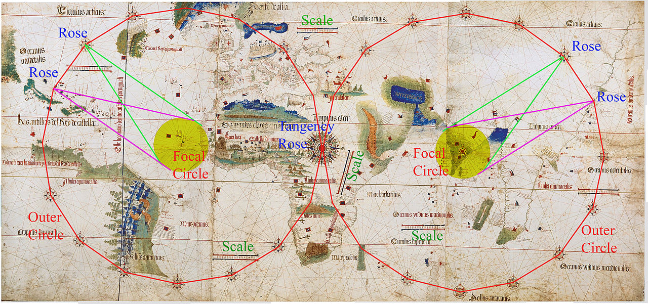
English: Illustration of the construction of the compass rhumb lines in the Cantino Planisphere (1502). The construction is based on two focal circles, the western circle centered on Cape Verde, the eastern circle in India. Each focal circle has an implied outer circle, which together cover most of the map. The circumference of each outer circle is ringed with sixteen equidistant 32-point compass roses - sometimes an elaborately drawn compass rose, sometimes a mere confluence of lines (when drawing would conflict with the coastal details). The western and eastern outer circles are tangent to each other at the rose in central Africa. The map also has several scattered scale bars to help measure distances (incuding an untypical diagonal bar for the coast of Mozambique).
Français : Illustration de la construction des lignes de rhumb de boussole dans le Planisphere de Cantino, 1502. La construction est basée sur deux cercles de focalisation, le cercle occidental centré sur le Cap Vert, le cercle oriental sur l'Inde. Chaque disque de focalisation a un cercle externe implicite. Les deux cercles combinés couvrent la majeure partie de la carte. La circonférence de chaque cercle externe est ponctuée de seize roses de boussole équidistantes de 32 points. Parfois une rose de boussole est minutieusement dessinée. Parfois, on observe simplement la convergence de lignes quand le dessin de la rose risquerait de cacher les détails des côtes. Les cercles externes occidentaux et orientaux sont tangents entre eux. Ce point de contact est matérialisé par une la rose des vents au centre de l'Afrique. La carte comporte également plusieurs échelles en barre, dispersées. L'une d'entre elles, portée de manière originale en oblique, dans l'est de l'Afrique. Ces barres permettent de mesurer les distances. |
||
| Date | |||
| Source |
|
||
| Author | Anonymous |
|
This is a faithful photographic reproduction of a two-dimensional, public domain work of art. The work of art itself is in the public domain for the following reason:
The official position taken by the Wikimedia Foundation is that "faithful reproductions of two-dimensional public domain works of art are public domain".
This photographic reproduction is therefore also considered to be in the public domain in the United States. In other jurisdictions, re-use of this content may be restricted; see Reuse of PD-Art photographs for details. | ||||
File history
Click on a date/time to view the file as it appeared at that time.
| Date/Time | Thumbnail | Dimensions | User | Comment | |
|---|---|---|---|---|---|
| current | 00:41, 25 June 2011 | | 3,528 × 1,656 (3.34 MB) | Walrasiad (talk | contribs) | {{Information |Description=Illustration of the construction of the compass rhumb lines in the Cantino Planisphere (1502). The construction is based on two focal circles, the western circle centered on Cape Verde, the eastern cir |
You cannot overwrite this file.
File usage on Commons
There are no pages that use this file.
File usage on other wikis
The following other wikis use this file:
- Usage on fr.wikipedia.org
.jpg&oldid=866712718)