File:ComputerHotline - Fort de Bourlemont (by) (8).jpg
跳转到导航
跳转到搜索
本预览的尺寸:800 × 519像素。 其他分辨率:320 × 208像素 | 640 × 415像素 | 1,024 × 664像素 | 1,280 × 830像素 | 2,560 × 1,660像素 | 4,216 × 2,734像素。
原始文件 (4,216 × 2,734像素,文件大小:7.51 MB,MIME类型:image/jpeg)
说明
说明
添加一行文字以描述该文件所表现的内容
其他语言:
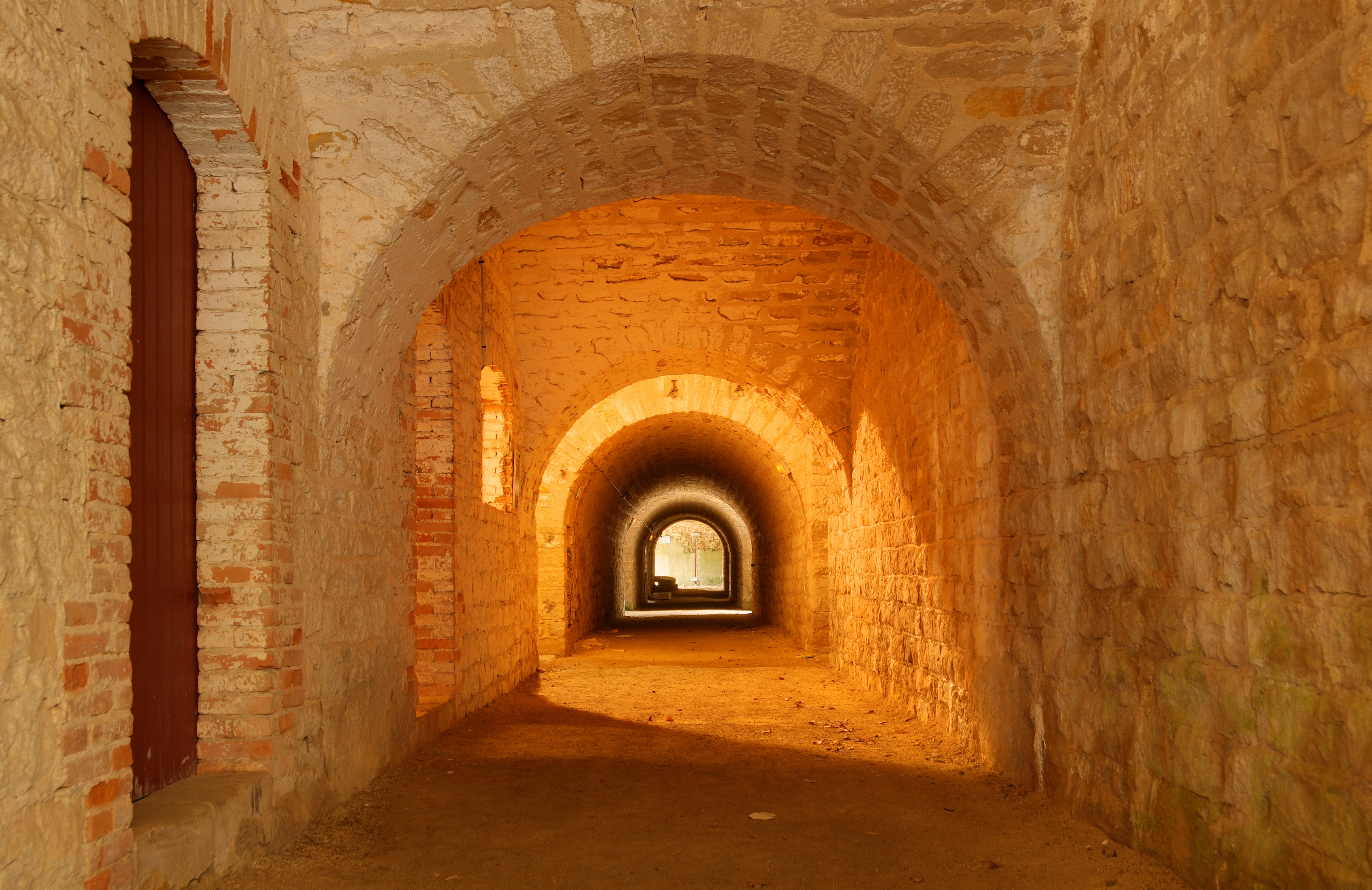
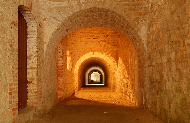
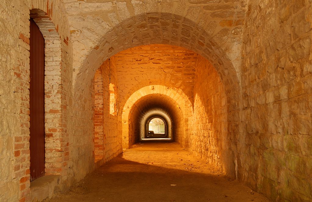
Italiano: Un corridoio interno di Fort de Bourlémont: una fortezza di frontiera francese (sistema Séré de Rivières) che presidiava il cosiddetto trouée de Charmes (intervallo di Charmes), un altopiano di interesse strategico compreso tra le linee fortificate di Toul ed Épinal. Nederlands: Corridor in het Fort de Bourlémont in het dorp Mont-lès-Neufchâteau in de Franse regio Lotharingen. Het fort, beter bekend als 'Fort Choiseul', vormde onderdeel van de Système Séré de Rivières, het Oost-Franse systeem van kust- en grensverdedigingswerken dat in de jaren 1870 werd opgericht na de door Frankrijk verloren Frans-Duitse Oorlog. Het fort ligt op een plateau en vormde een verbinding tussen de steden Toul en Épinal. বাংলা : ফ্রান্সের ফোর্ট দি বুলেমঁ-এর অভ্যন্তরের দৃশ্য। 日本語: フランス、ロレーヌの Bourlémont 要塞の内部。撮影:Bresson Thomas 中文: 法国洛林区蒙莱纳夫夏托市布尔蒙城堡内部 中文(繁體): 法國洛林區蒙萊納夫夏托市布爾蒙城堡內部 |
| 描述 |
English: HDR picture of Bourlémont Fortifications.
Français : Image HDR du fort de Bourlémont.
Italiano: Un corridoio interno del Fort de Bourlémont: una fortificazione di frontiera francese (sistema Séré de Rivières) che presidiava il cosiddetto trouée de Charmes (intervallo di Charmes), un altopiano di interesse strategico compreso tra le linee fortificate di Toul ed Épinal.
|
||||||||||||||||||||||
| 日期 | |||||||||||||||||||||||
| 来源 |
|
||||||||||||||||||||||
| 作者 |
Thomas Bresson from Belfort, France
|
||||||||||||||||||||||

| 相机位置 | | 在以下服务上查看本图像和附近其他图像: OpenStreetMap |
|---|
|

_(8).jpg¶ms=048.363733_N_0005.644119_E_globe:Earth_type:camera_source:Flickr_&language=zh)
_(8).jpg)
许可协议[编辑]
_(8).jpg&action=edit§ion=1)
| 此张图片原发布于Flickr,在March 31, 2010由管理员或审查员File Upload Bot (Magnus Manske)检查后,确认检查时图片在Flickr的版权声明与维基共享资源的版权使用方针相符。 |
文件历史
点击某个日期/时间查看对应时刻的文件。
| 日期/时间 | 缩略图 | 大小 | 用户 | 备注 | |
|---|---|---|---|---|---|
| 当前 | 2010年3月31日 (三) 06:54 | | 4,216 × 2,734(7.51 MB) | File Upload Bot (Magnus Manske)(留言 | 贡献) | {{Information |Description=Bourl�mont Fortifications (HDR). |Source=[http://www.flickr.com/photos/36519414@N00/4476010277/ Fort de Bourl�mont] * Uploaded by ComputerHotline |Date=2010-03-28 09:49 |Author=[http://www.flickr.com |
您不可以覆盖此文件。
文件用途
以下50个页面使用本文件:
- User:ComputerHotline/Archive 1
- User:ComputerHotline/examples (3)
- User:Ö/Best/2010
- Commons:Featured picture candidates/File:ComputerHotline - Fort de Bourlemont (by) (8).jpg
- Commons:Featured picture candidates/Log/April 2010
- Commons:Featured pictures/Places/Interiors
- Commons:Featured pictures/chronological/2010-A
- Commons:Picture of the Year/2010/Galleries/2010-A
- Commons:Picture of the Year/2010/Galleries/All
- Commons:Picture of the Year/2010/Galleries/Index/5
- Commons:Picture of the Year/2010/Galleries/Index/Interiors
- Commons:Picture of the Year/2010/Galleries/Interiors
- Commons:Picture of the Year/2010/Galleries/Interiors/Large
- Commons:Picture of the Year/2010/Galleries/Interiors/Small
- Commons:Picture of the Year/2010/Galleries/Table
- Commons:Picture of the Year/2010/Galleries/Table/04
- Commons:Picture of the Year/2010/R1/File:ComputerHotline - Fort de Bourlemont (by) (8).jpg
- Commons:Picture of the Year/2010/Results/R1/ALL/Table
- Commons:Picture of the Year/2010/Results/R1/Interiors
- Commons:Picture of the Year/2010/Results/R1/Interiors/Table
- Commons:Potd/2010-07 (da)
- Commons:Potd/2010-07 (de)
- Commons:Potd/2010-07 (nl)
- Commons:Potd/2010-07 (pt)
- Commons:Quality images/Subject/Places/Man made structures/Buildings, Interior
- Commons:Quality images candidates/Archives April 2010
- Commons talk:Picture of the Year/2010/Galleries/Table
- Commons talk:Quality images/Subject/Places/Man made structures
- Template:Potd/2010-07
- Template:Potd/2010-07-05
- Template:Potd/2010-07-05 (bn)
- Template:Potd/2010-07-05 (cs)
- Template:Potd/2010-07-05 (da)
- Template:Potd/2010-07-05 (de)
- Template:Potd/2010-07-05 (en)
- Template:Potd/2010-07-05 (es)
- Template:Potd/2010-07-05 (fr)
- Template:Potd/2010-07-05 (hu)
- Template:Potd/2010-07-05 (it)
- Template:Potd/2010-07-05 (ja)
- Template:Potd/2010-07-05 (mk)
- Template:Potd/2010-07-05 (nb)
- Template:Potd/2010-07-05 (nl)
- Template:Potd/2010-07-05 (pl)
- Template:Potd/2010-07-05 (pt)
- Template:Potd/2010-07-05 (sv)
- Template:Potd/2010-07-05 (zh-hans)
- Template:Potd/2010-07-05 (zh-hant)
- Template:Potd/2010-07/short
- Template:Potd/2010-07 (zh-hans)
_(8).jpg)
全域文件用途
以下其他wiki使用此文件:
- bn.wikipedia.org上的用途
- crh.wikipedia.org上的用途
- cv.wikipedia.org上的用途
- fa.wikipedia.org上的用途
- fr.wikipedia.org上的用途
- hu.wikipedia.org上的用途
- ko.wikipedia.org上的用途
- krc.wikipedia.org上的用途
- lbe.wikipedia.org上的用途
- mg.wikipedia.org上的用途
- mk.wikipedia.org上的用途
- os.wikipedia.org上的用途
- pl.wikipedia.org上的用途
- pt.wikipedia.org上的用途
- ru.wikipedia.org上的用途
- ru.wikinews.org上的用途
- sah.wikipedia.org上的用途
- uk.wikipedia.org上的用途
- vi.wikipedia.org上的用途
- xal.wikipedia.org上的用途
- zh.wikipedia.org上的用途
_(8).jpg&oldid=866853950)