File:Concord Parish, New South Wales 1840.png
Jump to navigation
Jump to search
Size of this preview: 698 × 600 pixels. Other resolutions: 279 × 240 pixels | 559 × 480 pixels | 747 × 642 pixels.
Original file (747 × 642 pixels, file size: 909 KB, MIME type: image/png)
Captions
Captions
Add a one-line explanation of what this file represents
Summary
[edit]
| Description |
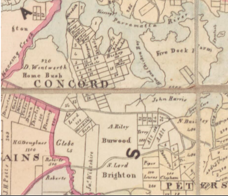
English: Map of Concord Parish, New South Wales in 1840.[1] |
| Date | |
| Source | [http://nla.gov.au/nla.obj-229932091/view |
| Author | William Henry Wells, A map of the County of Cumberland in the Colony of New South Wales (William Baker, 1840). |
Licensing
[edit]
|
This work is in the public domain in its country of origin and other countries and areas where the copyright term is the author's life plus 70 years or fewer. This work is in the public domain in the United States because it was published (or registered with the U.S. Copyright Office) before January 1, 1929. | |
| This file has been identified as being free of known restrictions under copyright law, including all related and neighboring rights. | |
- ↑ William Henry Wells, A map of the County of Cumberland in the Colony of New South Wales (William Baker, 1840).
File history
Click on a date/time to view the file as it appeared at that time.
| Date/Time | Thumbnail | Dimensions | User | Comment | |
|---|---|---|---|---|---|
| current | 06:10, 8 June 2018 | | 747 × 642 (909 KB) | D A R C 12345 (talk | contribs) | User created page with UploadWizard |
You cannot overwrite this file.
File usage on Commons
There are no pages that use this file.
File usage on other wikis
The following other wikis use this file:
- Usage on en.wikipedia.org