File:Confederate States of America.svg
跳至導覽
跳至搜尋

此 SVG 檔案的 PNG 預覽的大小:800 × 501 像素。 其他解析度:320 × 200 像素 | 640 × 401 像素 | 1,024 × 642 像素 | 1,280 × 802 像素 | 2,560 × 1,604 像素 | 913 × 572 像素。
原始檔案 (SVG 動畫檔案,表面大小:913 × 572 像素,檔案大小:57 KB)
注意:由於技術限制,此檔案縮圖無動畫效果。
說明
說明
添加單行說明來描述出檔案所代表的內容
摘要
[編輯]
| 描述 |
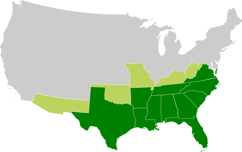
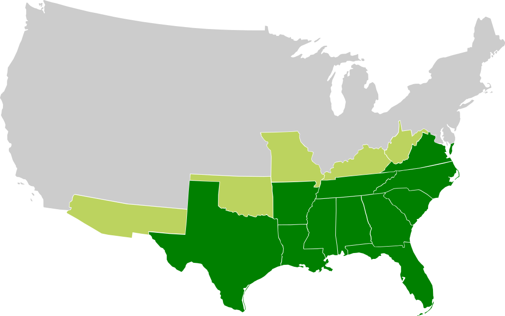
A map of the Confederate States of America, Maryland and claimed states and territories.
States that seceeded under CSA control
States and territories claimed by CSA without formal secession and/or control |
| 日期 | |
| 來源 | 自己的作品 |
| 作者 |
|
| 其他版本 | File:Csa5-3.gif |
授權條款
[編輯]
此檔案採用創用CC 姓名標示-相同方式分享 3.0 未在地化版本授權條款。
- 您可以自由:
- 分享 – 複製、發佈和傳播本作品
- 重新修改 – 創作演繹作品
- 惟需遵照下列條件:
- 姓名標示 – 您必須指名出正確的製作者,和提供授權條款的連結,以及表示是否有對內容上做出變更。您可以用任何合理的方式來行動,但不得以任何方式表明授權條款是對您許可或是由您所使用。
- 相同方式分享 – 如果您利用本素材進行再混合、轉換或創作,您必須基於如同原先的相同或兼容的條款,來分布您的貢獻成品。
檔案歷史
點選日期/時間以檢視該時間的檔案版本。
| 日期/時間 | 縮圖 | 尺寸 | 使用者 | 備註 | |
|---|---|---|---|---|---|
| 目前 | 2009年11月27日 (五) 16:23 | | 913 × 572(57 KB) | Lexicon(留言 | 貢獻) | Reverted to version as of 08:57, 21 March 2008 as new version is different image used for different purposes, and not an SVG file |
| 2009年11月26日 (四) 00:56 |  | 640 × 419(34 KB) | Major General Sterling Price(留言 | 貢獻) | this is the Confederate States today if they won the Civil War | |
| 2008年3月21日 (五) 08:57 |  | 913 × 572(57 KB) | Nkocharh(留言 | 貢獻) | I forgot Kentucky! | |
| 2008年3月21日 (五) 08:49 |  | 913 × 572(55 KB) | Nkocharh(留言 | 貢獻) | {{Information |Description=A map of the Confederate Sates of America |Source=self-made |Date=21 March 2008 |Author= Nkocharh |Permission= |other_versions= }} |
無法覆蓋此檔案。
檔案用途
沒有使用此檔案的頁面。
全域檔案使用狀況
以下其他 wiki 使用了這個檔案:
- af.wikipedia.org 的使用狀況
- arz.wikipedia.org 的使用狀況
- bn.wikipedia.org 的使用狀況
- br.wikipedia.org 的使用狀況
- da.wikipedia.org 的使用狀況
- de.wikipedia.org 的使用狀況
- de.wiktionary.org 的使用狀況
- el.wikipedia.org 的使用狀況
- en.wikipedia.org 的使用狀況
- Alabama
- Arkansas
- Confederate States of America
- Louisiana
- North Carolina
- South Carolina
- Texas
- Tennessee
- Virginia
- West Virginia
- Georgia (U.S. state)
- Confederate Arizona
- West Virginia in the American Civil War
- User:Nkocharh
- Missouri in the American Civil War
- Florida in the American Civil War
- Kentucky in the American Civil War
- Alabama in the American Civil War
- Mississippi in the American Civil War
- South Carolina in the American Civil War
- Tennessee in the American Civil War
- Texas in the American Civil War
- Georgia in the American Civil War
- North Carolina in the American Civil War
- Virginia in the American Civil War
- Template:Confederate States political divisions
- Arkansas in the American Civil War
- Louisiana in the American Civil War
- Confederate government of Kentucky
- Wikipedia:Graphics Lab/Images to improve/Archive/Mar 2008
- Mississippi
- Secession in the United States
- Florida
- Conclusion of the American Civil War
- 1861 in the United States
- Talk:Muscogee Nation
檢視此檔案的更多全域使用狀況。