File:Congo Democratic Republic Map.jpg
跳至導覽
跳至搜尋

預覽大小:542 × 600 像素。 其他解析度:217 × 240 像素 | 434 × 480 像素 | 694 × 768 像素 | 1,070 × 1,184 像素。
原始檔案 (1,070 × 1,184 像素,檔案大小:252 KB,MIME 類型:image/jpeg)
說明
說明
添加單行說明來描述出檔案所代表的內容
| 描述 | ||||
| 日期 | ||||
| 來源 | [1] from the Perry-Castañeda Library Map Collection. | |||
| 作者 | CIA | |||
| 授權許可 (重用此檔案) |
|

![[1]](http://www.lib.utexas.edu/maps/africa/congo_demrep_rel98.jpg)
檔案歷史
點選日期/時間以檢視該時間的檔案版本。
| 日期/時間 | 縮圖 | 尺寸 | 使用者 | 備註 | |
|---|---|---|---|---|---|
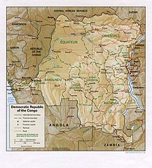
| 目前 | 2006年2月21日 (二) 12:05 | | 1,070 × 1,184(252 KB) | Lupo(留言 | 貢獻) | Shaded relief map of the Democratic Republic of the Congo (the former Zaire). Source: [http://www.lib.utexas.edu/maps/africa/congo_demrep_rel98.jpg] from the [http://www.lib.utexas.edu/maps/zaire.html Perry-Castañeda Library Map Collection]. {{ |
無法覆蓋此檔案。
檔案用途
下列4個頁面有用到此檔案:
全域檔案使用狀況
以下其他 wiki 使用了這個檔案:
- de.wikipedia.org 的使用狀況
- en.wikipedia.org 的使用狀況
- es.wikipedia.org 的使用狀況
- it.wikipedia.org 的使用狀況
- lt.wikipedia.org 的使用狀況
- pl.wikipedia.org 的使用狀況
- uk.wikipedia.org 的使用狀況
- vec.wikipedia.org 的使用狀況
- zh.wikipedia.org 的使用狀況