File:Cooch-behar-enclaves-schematisch.png
跳转到导航
跳转到搜索
本预览的尺寸:307 × 599像素。 其他分辨率:123 × 240像素 | 246 × 480像素 | 393 × 768像素 | 1,100 × 2,148像素。
原始文件 (1,100 × 2,148像素,文件大小:694 KB,MIME类型:image/png)
说明
说明
添加一行文字以描述该文件所表现的内容

|
此map图片可使用矢量图形重新创建为SVG文件。这具有很多好处;更多信息请参见共享资源:待清理媒体。如果存在此图片的SVG格式,请将其上传,然后将此模板替换为
{{vector version available|新图片名称}}。
建议您将SVG命名为“Cooch-behar-enclaves-schematisch.svg”,这样在使用Vector version available(或Vva)模板时就不需要填写新图片名称参数。 |
摘要
[编辑]
| 描述 |
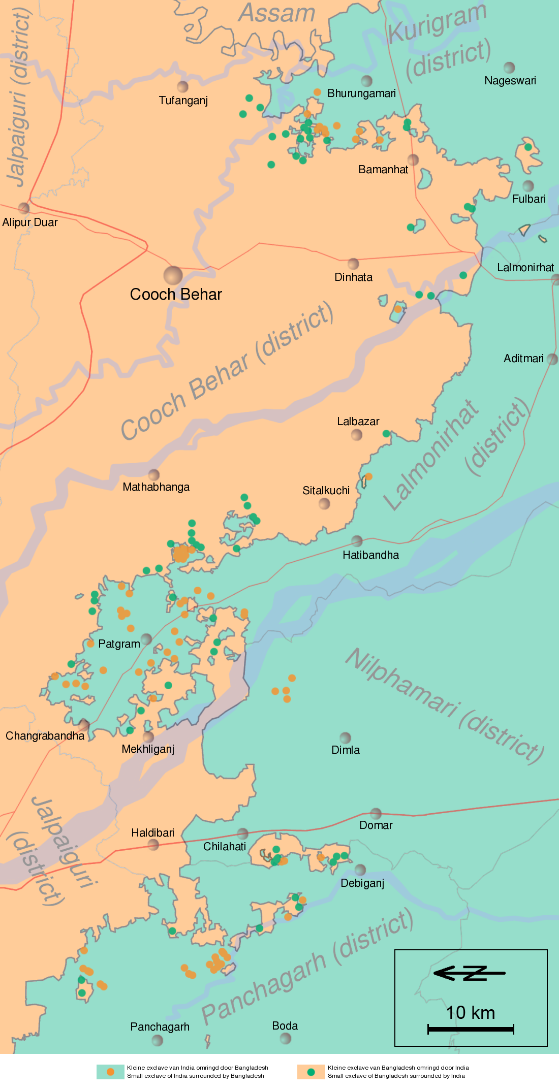
English: Schematic map of the Cooch Behar enclaves on the border of India and Bangladesh. The top of the map points to the east.
Nederlands: Schematische kaart van de Cooch Behar enclaves op de grens van India en Bangladesh. De bovenkant wijst naar het oosten. |
| 日期 | (UTC) |
| 来源 | Information in "Waiting for the esquimo: An historical and documentary study of the Cooch Behar enclaves of India and Bangladesh" door Brendan R. Whyte (2002), [1], Google Maps and other map sources |
| 作者 | Jeroen |
![[1]](http://geosite.jankrogh.com/enklaver/CoochBehar_Annotated.jpg)
许可协议
[编辑]
我,本作品著作权人,特此采用以下许可协议发表本作品:

|
已授权您依据自由软件基金会发行的无固定段落及封面封底文字(Invariant Sections, Front-Cover Texts, and Back-Cover Texts)的GNU自由文件许可协议1.2版或任意后续版本的条款,复制、传播和/或修改本文件。该协议的副本请见“GNU Free Documentation License”。 |
| 本文件采用知识共享署名-相同方式共享 3.0 未本地化版本许可协议授权。 | ||
| ||
| 本许可协议标签作为GFDL许可协议更新的组成部分被添加至本文件。 |
- 您可以自由地:
- 共享 – 复制、发行并传播本作品
- 修改 – 改编作品
- 惟须遵守下列条件:
- 署名 – 您必须对作品进行署名,提供授权条款的链接,并说明是否对原始内容进行了更改。您可以用任何合理的方式来署名,但不得以任何方式表明许可人认可您或您的使用。
- 相同方式共享 – 如果您再混合、转换或者基于本作品进行创作,您必须以与原先许可协议相同或相兼容的许可协议分发您贡献的作品。
您可以选择您需要的许可协议。
原始上传日志
[编辑]
| date/time | username | resolution | size | edit summary | |
|---|---|---|---|---|---|
| 12:03, 12 April 2008 | User:Gpvos | <a href="http://upload.wikimedia.org/wikipedia/commons/2/22/Cooch-behar-enclaves-systematisch.png[失效链接]"><img alt="Thumbnail for version as of 12:03, 12 April 2008" src="http://upload.wikimedia.org/wikipedia/commons/thumb/2/22/Cooch-behar-enclaves-systematisch.png/61px-Cooch-behar-enclaves-systematisch.png[失效链接]" width="61" height="119" border="0" /></a> | 1,100×2,148 | 642 KB | spelling fix (also optimized png) {{self|GFDL|cc-by-sa-2.5,2.0,1.0|author=<a href="/wiki/User:Jeroen" class="mw-redirect" title="User:Jeroen">User:Jeroen</a>}} |
| 22:53, 14 May 2007 | User:Jeroencommons | <a href="http://upload.wikimedia.org/wikipedia/commons/archive/2/22/20080412120354%21Cooch-behar-enclaves-systematisch.png[失效链接]"><img alt="Thumbnail for version as of 22:53, 14 May 2007" src="http://upload.wikimedia.org/wikipedia/commons/thumb/archive/2/22/20080412120354%21Cooch-behar-enclaves-systematisch.png/61px-Cooch-behar-enclaves-systematisch.png[失效链接]" width="61" height="119" border="0" /></a> | 1,100×2,148 | 690 KB | |
| 21:22, 13 May 2007 | User:Jeroencommons | <a href="http://upload.wikimedia.org/wikipedia/commons/archive/2/22/20070514225354%21Cooch-behar-enclaves-systematisch.png[失效链接]"><img alt="Thumbnail for version as of 21:22, 13 May 2007" src="http://upload.wikimedia.org/wikipedia/commons/thumb/archive/2/22/20070514225354%21Cooch-behar-enclaves-systematisch.png/61px-Cooch-behar-enclaves-systematisch.png[失效链接]" width="61" height="119" border="0" /></a> | 1,100×2,148 | 691 KB | {{Information |Description= Systematische kaart van de Cooch Behar enclaves op de grens van India en Bangladesh // Systematic map of the Cooch Behar enclaves on the border of India and Bangladesh |Source= Information in [http://eprints.unimelb.edu.au/arch |
文件历史
点击某个日期/时间查看对应时刻的文件。
| 日期/时间 | 缩略图 | 大小 | 用户 | 备注 | |
|---|---|---|---|---|---|
| 当前 | 2011年11月29日 (二) 13:11 | | 1,100 × 2,148(694 KB) | W like wiki(留言 | 贡献) | scale and north added |
| 2008年10月5日 (日) 04:38 |  | 1,100 × 2,148(642 KB) | BetacommandBot(留言 | 贡献) | move approved by: User:Common Good This image was moved from Image:Cooch-behar-enclaves-systematisch.png == {{int:filedesc}} == {{Information |Description= Schematische kaart van de Cooch Behar enclaves op de grens van India en Bangladesh. De b |
您不可以覆盖此文件。
文件用途
没有页面使用本文件。
全域文件用途
以下其他wiki使用此文件:
- bn.wikipedia.org上的用途
- ca.wikipedia.org上的用途
- de.wikipedia.org上的用途
- en.wikipedia.org上的用途
- es.wikipedia.org上的用途
- fi.wikipedia.org上的用途
- fr.wikipedia.org上的用途
- Liste d'enclaves et d'exclaves
- Enclaves indo-bangladaises
- Discussion:Enclaves indo-bangladaises
- Utilisateur:GhosterBot/BacASable/Le saviez-vous ?/Archives
- Wikipédia:Le saviez-vous ?/Archives/2023
- Wikipédia:Statistiques des anecdotes de la page d'accueil/Visibilité des anecdotes (2023)
- Wikipédia:Statistiques des anecdotes de la page d'accueil/Visibilité des anecdotes (2023)/2023 09
- Discussion:Enclaves indo-bangladaises/LSV 22579
- Wikipédia:Réseaux sociaux/X/Publications/archives/septembre 2023
- hi.wikipedia.org上的用途
- id.wikipedia.org上的用途
- it.wikipedia.org上的用途
- ja.wikipedia.org上的用途
- ko.wikipedia.org上的用途
- mt.wikipedia.org上的用途
- nl.wikipedia.org上的用途
- pl.wikipedia.org上的用途
- pt.wikipedia.org上的用途
- ru.wikipedia.org上的用途
- sq.wikipedia.org上的用途
- te.wikipedia.org上的用途
- th.wikipedia.org上的用途
- uk.wikipedia.org上的用途
- www.wikidata.org上的用途
- xmf.wikipedia.org上的用途
- zh.wikipedia.org上的用途