File:Cooch-behar-enclaves-schematisch.png
跳至導覽
跳至搜尋
預覽大小:307 × 599 像素。 其他解析度:123 × 240 像素 | 246 × 480 像素 | 393 × 768 像素 | 1,100 × 2,148 像素。
原始檔案 (1,100 × 2,148 像素,檔案大小:694 KB,MIME 類型:image/png)
說明
說明
添加單行說明來描述出檔案所代表的內容

|
本圖片是以PNG、GIF或JPEG格式上傳。然而,其中包含的資料或訊息,應該重新建立成可縮放向量圖形(SVG)檔案,以更有效率或更準確的方式儲存。如有可能,請上傳本圖片的SVG格式版本。在上傳之後,請修改維基各姊妹計畫中所有使用舊版圖片的條目(列在圖像連結章節中),替換為新版圖片,並在舊圖片的描述頁中加入{{Vector version available|新圖片名稱.svg}}模板,同時移除本模板。
|
摘要
[編輯]
| 描述 |
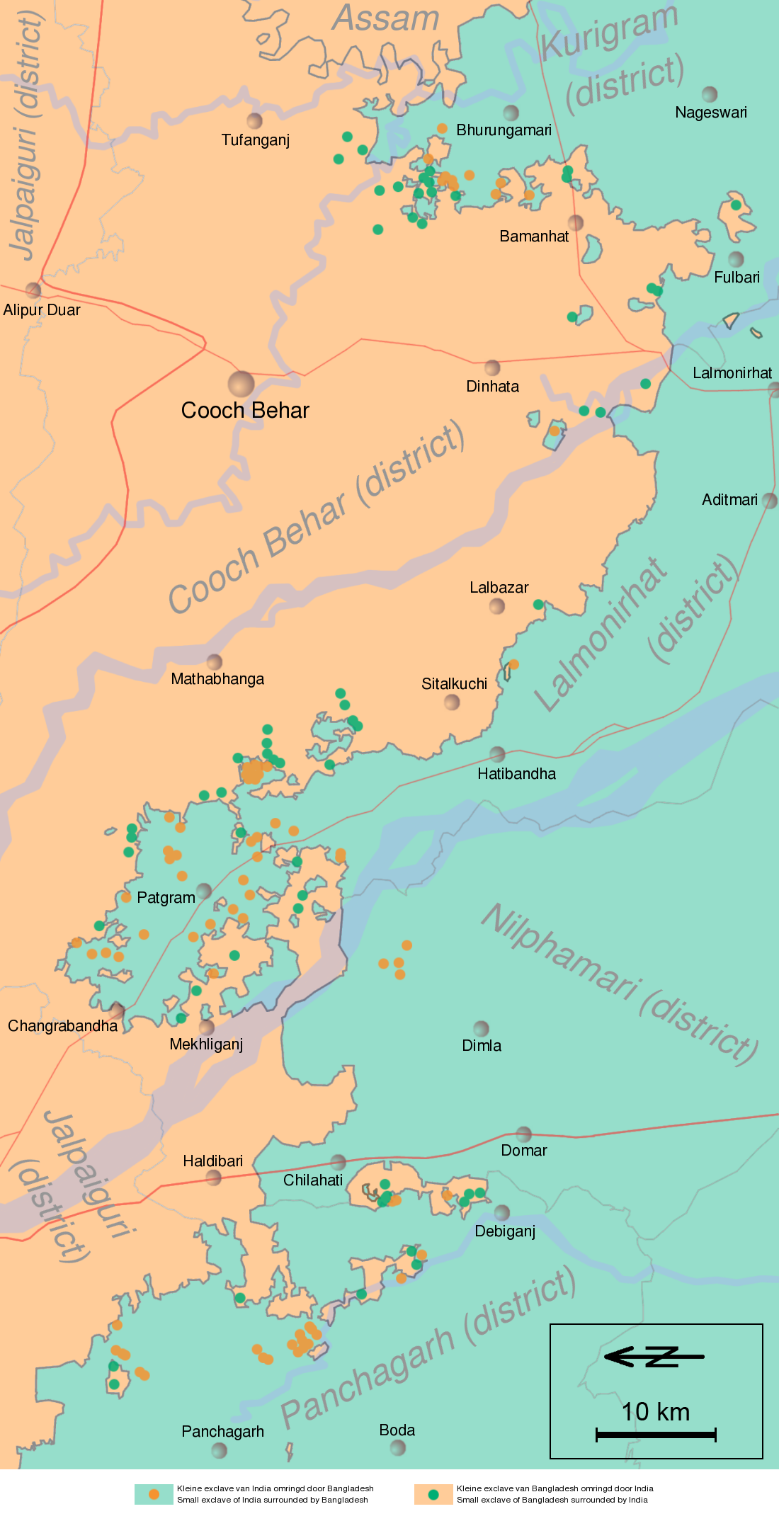
English: Schematic map of the Cooch Behar enclaves on the border of India and Bangladesh. The top of the map points to the east.
Nederlands: Schematische kaart van de Cooch Behar enclaves op de grens van India en Bangladesh. De bovenkant wijst naar het oosten. |
| 日期 | (UTC) |
| 來源 | Information in "Waiting for the esquimo: An historical and documentary study of the Cooch Behar enclaves of India and Bangladesh" door Brendan R. Whyte (2002), [1], Google Maps and other map sources |
| 作者 | Jeroen |
![[1]](http://geosite.jankrogh.com/enklaver/CoochBehar_Annotated.jpg)
授權條款
[編輯]
我,本作品的著作權持有者,決定用以下授權條款發佈本作品:

|
已授權您依據自由軟體基金會發行的無固定段落、封面文字和封底文字GNU自由文件授權條款1.2版或任意後續版本,對本檔進行複製、傳播和/或修改。該協議的副本列在GNU自由文件授權條款中。 |
| 此檔案採用共享創意 姓名標示-相同方式分享 3.0 未在地化版本授權條款。 | ||
| ||
| 已新增授權條款標題至此檔案,作為GFDL授權更新的一部份。 |
您可以選擇您需要的授權條款。
原始上傳日誌
[編輯]
| date/time | username | resolution | size | edit summary | |
|---|---|---|---|---|---|
| 12:03, 12 April 2008 | User:Gpvos | <a href="http://upload.wikimedia.org/wikipedia/commons/2/22/Cooch-behar-enclaves-systematisch.png[失效連結]"><img alt="Thumbnail for version as of 12:03, 12 April 2008" src="http://upload.wikimedia.org/wikipedia/commons/thumb/2/22/Cooch-behar-enclaves-systematisch.png/61px-Cooch-behar-enclaves-systematisch.png[失效連結]" width="61" height="119" border="0" /></a> | 1,100×2,148 | 642 KB | spelling fix (also optimized png) {{self|GFDL|cc-by-sa-2.5,2.0,1.0|author=<a href="/wiki/User:Jeroen" class="mw-redirect" title="User:Jeroen">User:Jeroen</a>}} |
| 22:53, 14 May 2007 | User:Jeroencommons | <a href="http://upload.wikimedia.org/wikipedia/commons/archive/2/22/20080412120354%21Cooch-behar-enclaves-systematisch.png[失效連結]"><img alt="Thumbnail for version as of 22:53, 14 May 2007" src="http://upload.wikimedia.org/wikipedia/commons/thumb/archive/2/22/20080412120354%21Cooch-behar-enclaves-systematisch.png/61px-Cooch-behar-enclaves-systematisch.png[失效連結]" width="61" height="119" border="0" /></a> | 1,100×2,148 | 690 KB | |
| 21:22, 13 May 2007 | User:Jeroencommons | <a href="http://upload.wikimedia.org/wikipedia/commons/archive/2/22/20070514225354%21Cooch-behar-enclaves-systematisch.png[失效連結]"><img alt="Thumbnail for version as of 21:22, 13 May 2007" src="http://upload.wikimedia.org/wikipedia/commons/thumb/archive/2/22/20070514225354%21Cooch-behar-enclaves-systematisch.png/61px-Cooch-behar-enclaves-systematisch.png[失效連結]" width="61" height="119" border="0" /></a> | 1,100×2,148 | 691 KB | {{Information |Description= Systematische kaart van de Cooch Behar enclaves op de grens van India en Bangladesh // Systematic map of the Cooch Behar enclaves on the border of India and Bangladesh |Source= Information in [http://eprints.unimelb.edu.au/arch |
檔案歷史
點選日期/時間以檢視該時間的檔案版本。
| 日期/時間 | 縮圖 | 尺寸 | 用戶 | 備註 | |
|---|---|---|---|---|---|
| 目前 | 2011年11月29日 (二) 13:11 | | 1,100 × 2,148(694 KB) | W like wiki(對話 | 貢獻) | scale and north added |
| 2008年10月5日 (日) 04:38 |  | 1,100 × 2,148(642 KB) | BetacommandBot(對話 | 貢獻) | move approved by: User:Common Good This image was moved from Image:Cooch-behar-enclaves-systematisch.png == {{int:filedesc}} == {{Information |Description= Schematische kaart van de Cooch Behar enclaves op de grens van India en Bangladesh. De b |
無法覆蓋此檔案。
檔案用途
沒有使用此檔案的頁面。
全域檔案使用狀況
以下其他 wiki 使用了這個檔案:
- bn.wikipedia.org 的使用狀況
- ca.wikipedia.org 的使用狀況
- de.wikipedia.org 的使用狀況
- en.wikipedia.org 的使用狀況
- es.wikipedia.org 的使用狀況
- fi.wikipedia.org 的使用狀況
- fr.wikipedia.org 的使用狀況
- Liste d'enclaves et d'exclaves
- Enclaves indo-bangladaises
- Discussion:Enclaves indo-bangladaises
- Utilisateur:GhosterBot/BacASable/Le saviez-vous ?/Archives
- Wikipédia:Le saviez-vous ?/Archives/2023
- Wikipédia:Statistiques des anecdotes de la page d'accueil/Visibilité des anecdotes (2023)
- Wikipédia:Statistiques des anecdotes de la page d'accueil/Visibilité des anecdotes (2023)/2023 09
- Discussion:Enclaves indo-bangladaises/LSV 22579
- Wikipédia:Réseaux sociaux/X/Publications/archives/septembre 2023
- hi.wikipedia.org 的使用狀況
- id.wikipedia.org 的使用狀況
- it.wikipedia.org 的使用狀況
- ja.wikipedia.org 的使用狀況
- ko.wikipedia.org 的使用狀況
- mt.wikipedia.org 的使用狀況
- nl.wikipedia.org 的使用狀況
- pl.wikipedia.org 的使用狀況
- pt.wikipedia.org 的使用狀況
- ru.wikipedia.org 的使用狀況
- sq.wikipedia.org 的使用狀況
- te.wikipedia.org 的使用狀況
- th.wikipedia.org 的使用狀況
- uk.wikipedia.org 的使用狀況
- www.wikidata.org 的使用狀況
- xmf.wikipedia.org 的使用狀況
- zh.wikipedia.org 的使用狀況