File:Costa De Los Yndios Mosquitos.jpg
Jump to navigation
Jump to search

Size of this preview: 800 × 561 pixels. Other resolutions: 320 × 224 pixels | 640 × 449 pixels | 1,024 × 718 pixels | 1,280 × 898 pixels | 2,213 × 1,552 pixels.
Original file (2,213 × 1,552 pixels, file size: 464 KB, MIME type: image/jpeg)
Captions
Captions
Add a one-line explanation of what this file represents
Summary[edit]
| Description |
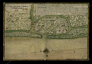
English: A stylized Spanish map by Luis Diez Navarro from 1765 showing the main British settlement at Black River in Moskitia. The map highlights the residence of William Pitt, the settlement’s 1732 founder, the grandson of a former governor of Bermuda, a distant relative of the eponymous British prime minister, and the father of Elizabeth Pitt Hodgson. |
| Date | |
| Source | http://bdh-rd.bne.es/viewer.vm?id=0000032229 |
| Author | Luis Diez Navarro |
Licensing[edit]
|
This work is in the public domain in its country of origin and other countries and areas where the copyright term is the author's life plus 70 years or fewer. This work is in the public domain in the United States because it was published (or registered with the U.S. Copyright Office) before January 1, 1929. | |
| This file has been identified as being free of known restrictions under copyright law, including all related and neighboring rights. | |
File history
Click on a date/time to view the file as it appeared at that time.
| Date/Time | Thumbnail | Dimensions | User | Comment | |
|---|---|---|---|---|---|
| current | 20:57, 20 July 2022 | | 2,213 × 1,552 (464 KB) | Thecaribbeancoast (talk | contribs) | Uploaded a work by Luis Diez Navarro from http://bdh-rd.bne.es/viewer.vm?id=0000032229 with UploadWizard |
You cannot overwrite this file.
File usage on Commons
There are no pages that use this file.
File usage on other wikis
The following other wikis use this file:
- Usage on en.wikipedia.org
- Usage on www.wikidata.org