File:Countries by irrigated land area in 2012.png
跳转到导航
跳转到搜索
本预览的尺寸:800 × 460像素。 其他分辨率:320 × 184像素 | 640 × 368像素 | 1,024 × 589像素 | 1,280 × 736像素 | 2,560 × 1,471像素 | 6,194 × 3,560像素。
原始文件 (6,194 × 3,560像素,文件大小:2.13 MB,MIME类型:image/png)
说明
说明
添加一行文字以描述该文件所表现的内容
摘要[编辑]
| 描述 |
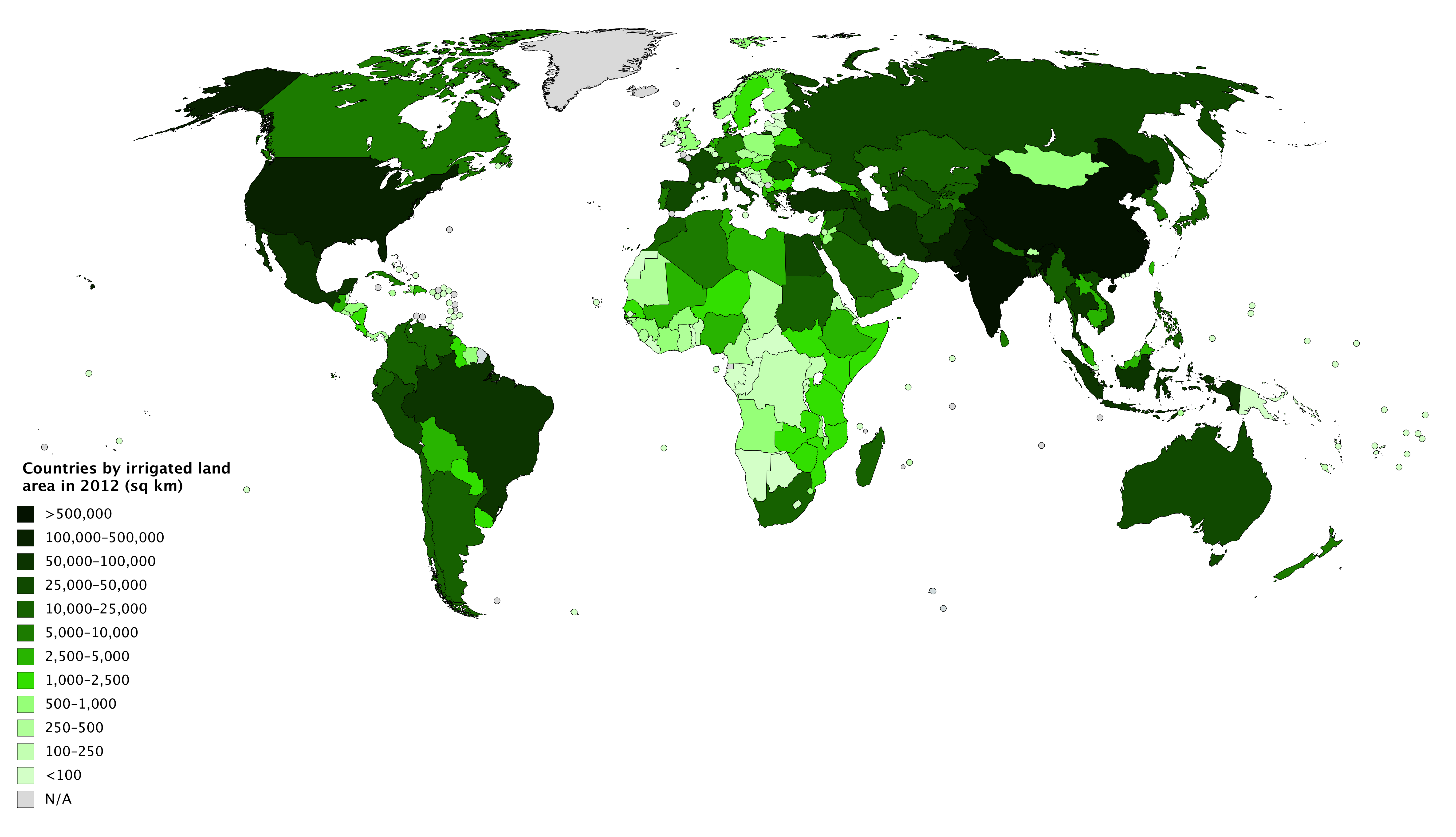
English: A choropleth map showing countries and territories by irrigated land area in square kilometres as of 2012, bases on data from The World Factbook of the Central Intelligence Agency. Countries/territories shown with irrigated land area as '0' are shaded with the '<100' colour (lightest green); those with no data are shaded with the 'N/A' colour (grey). |
| 日期 | |
| 来源 | 自己的作品 |
| 作者 | JackintheBox |
许可协议[编辑]
| This map was created for free at MapChart.net. All maps created there are licensed under the Creative Commons Attribution-ShareAlike 4.0 International License. See the "Licensing" link on the home page, or the MapChart.net feedback page for the image license info, and this MapChart.net Commons discussion. Use {{Mapchart.net}} to provide attribution for maps created with that service.
See also: Other maps on Commons created with Mapchart.net: Category:Mapchart.net and this search query; other map and chart resources. |
我,本作品著作权人,特此采用以下许可协议发表本作品:
本文件采用知识共享署名-相同方式共享 4.0 国际许可协议授权。
- 您可以自由地:
- 共享 – 复制、发行并传播本作品
- 修改 – 改编作品
- 惟须遵守下列条件:
- 署名 – 您必须对作品进行署名,提供授权条款的链接,并说明是否对原始内容进行了更改。您可以用任何合理的方式来署名,但不得以任何方式表明许可人认可您或您的使用。
- 相同方式共享 – 如果您再混合、转换或者基于本作品进行创作,您必须以与原先许可协议相同或相兼容的许可协议分发您贡献的作品。
文件历史
点击某个日期/时间查看对应时刻的文件。
| 日期/时间 | 缩略图 | 大小 | 用户 | 备注 | |
|---|---|---|---|---|---|
| 当前 | 2018年12月30日 (日) 06:34 | | 6,194 × 3,560(2.13 MB) | JackintheBox(留言 | 贡献) | User created page with UploadWizard |
您不可以覆盖此文件。
文件用途
没有页面使用本文件。
全域文件用途
以下其他wiki使用此文件:
- en.wikipedia.org上的用途
- fa.wikipedia.org上的用途
- ro.wikipedia.org上的用途
- zh.wikipedia.org上的用途