File:Countries driving on the left or right.svg
跳至導覽
跳至搜尋

此 SVG 檔案的 PNG 預覽的大小:800 × 406 像素。 其他解析度:320 × 162 像素 | 640 × 325 像素 | 1,024 × 520 像素 | 1,280 × 650 像素 | 2,560 × 1,300 像素 | 2,754 × 1,398 像素。
原始檔案 (SVG 檔案,表面大小:2,754 × 1,398 像素,檔案大小:1.1 MB)
說明
說明
添加單行說明來描述出檔案所代表的內容
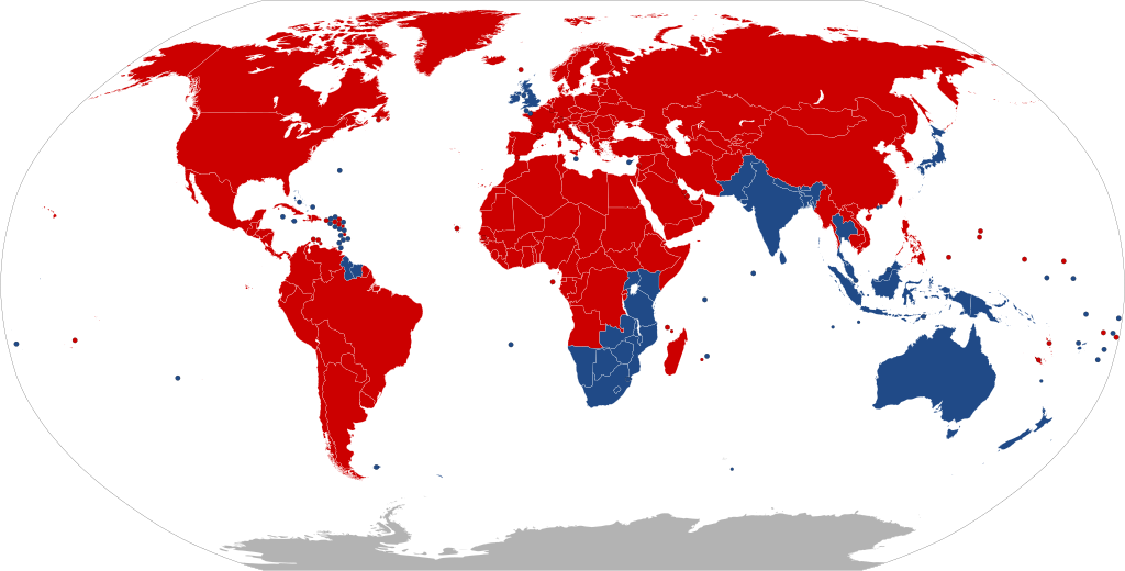
世界各國的道路通行方向示意圖。藍色代表靠左行駛,紅色代表靠右行駛。
| Colour | Explanation | |
|---|---|---|
| ↓↑ | Drives on right | |
| ↑↓ | Drives on left | |
| ? | No Information |
| 描述 |
Deutsch: Die Karte zeigt, in welchen Ländern der Erde Rechtsverkehr und in welchen Linksverkehr besteht.
Bosanski: Mapa pokazuje u kojim državama se vozi na desnoj strani ulice, a u kojim se vozi na lijevoj strani.
Català: Mapa que mostra en quins països es conduïx pel costat dret de la carretera, i en quins es conduïx pel costat esquerre.
English: A map indicating which countries drive on the right side of the road, and which drive on the left side.
Esperanto: Mapo indikanta, en kiuj landoj oni veturas sur la dekstra flanko de la strato, kaj en kiuj oni veturas sur la maldekstra flanko.
Español: Mapa que indica en cuáles países se maneja por el lado derecho o el lado izquierdo de la calle.
Bahasa Indonesia: Peta yang menunjukkan negara mana yang mengemudi di sisi kanan jalan, dan mana yang mengemudi di sisi kiri.
Íslenska: Kort sem sýnir hver lönd nota hægri umferð, og hver nota vinstri umferð.
Italiano: Mappa che indica in quali paesi si guida sul lato destro e in quali sul lato sinistro della strada.
日本語: 道路の右側を通行する国か左側を通行する国かを示した地図。
Nederlands: Deze kaart geeft aan in welke landen ter Wereld er Rechts en in welke er Links gereden wordt.
Polski: Mapa pokazująca, w jakich krajach jeździ się po prawej stronie drogi, a w których po lewej.
Русский: Карта с указанием, в каких странах ездят по правой стороне дороги и в каких ездят по левой стороне.
Türkçe: Trafiğin yolun sağ tarafından ve sol tarafından aktığını belirten ülkelerin haritası.
中文:显示世界上靠右行驶和靠左行驶的国家。 |
||
| 日期 | |||
| 來源 |
Created by bdesham in Inkscape from BlankMap-World6.svg, using information from Sens de circulation.png. |
||
| 作者 | Benjamin D. Esham (bdesham) | ||
| 授權許可 (重用此檔案) |
As a courtesy (but not a requirement), please e-mail me or leave a note on my talk page if you use this image outside of Wikipedia. Thanks! Benjamin D. Esham,此作品的版權所有人,決定用以下授權條款發佈本作品:
|
檔案歷史
點選日期/時間以檢視該時間的檔案版本。
| 日期/時間 | 縮圖 | 尺寸 | 用戶 | 備註 | |
|---|---|---|---|---|---|
| 目前 | 2020年5月26日 (二) 19:45 | | 2,754 × 1,398(1.1 MB) | Xophe84(對話 | 貢獻) | antarctica |
| 2020年4月26日 (日) 21:51 |  | 2,754 × 1,398(1.06 MB) | Hippymoose17(對話 | 貢獻) | Reverted to version as of 03:05, 23 April 2020 (UTC) | |
| 2020年4月26日 (日) 21:51 |  | 2,500 × 1,269(75 KB) | Hippymoose17(對話 | 貢獻) | ... | |
| 2020年4月23日 (四) 03:05 |  | 2,754 × 1,398(1.06 MB) | Numberguy6(對話 | 貢獻) | Fixed Cook Islands and Tokelau | |
| 2019年10月20日 (日) 17:46 |  | 2,754 × 1,398(1.06 MB) | Bdesham(對話 | 貢獻) | Replaced “Swaziland” with “Eswatini” and “The Former Yugoslav Republic of North Macedonia” with “North Macedonia.” | |
| 2019年4月4日 (四) 01:12 |  | 2,754 × 1,398(1.06 MB) | Newfraferz87(對話 | 貢獻) | Fixed Bulgaria & Bangladesh | |
| 2019年4月3日 (三) 11:36 |  | 940 × 477(1.63 MB) | BrightRaven(對話 | 貢獻) | Reverted to version as of 09:23, 2 April 2019 (UTC) Bulgaria does not drive on the left | |
| 2019年4月3日 (三) 11:07 |  | 2,754 × 1,398(1.06 MB) | Newfraferz87(對話 | 貢獻) | No explanation given for earlier reversion. Stick to optimized file | |
| 2019年4月2日 (二) 09:23 |  | 940 × 477(1.63 MB) | Nedops(對話 | 貢獻) | Reverted to version as of 20:07, 2 September 2016 (UTC) | |
| 2019年4月2日 (二) 09:03 |  | 2,754 × 1,398(1.06 MB) | Newfraferz87(對話 | 貢獻) | April 1 template |
無法覆蓋此檔案。
檔案用途
下列17個頁面有用到此檔案:
- User:Bdesham/Images
- User:Chumwa/OgreBot/Potential transport maps/2019 April 1-10
- User:Chumwa/OgreBot/Potential transport maps/2019 October 11-20
- User:Chumwa/OgreBot/Transport Maps/2019 April 1-10
- User:Chumwa/OgreBot/Transport Maps/2019 October 11-20
- User:Chumwa/OgreBot/Transport Maps/2020 April 21-30
- User:Chumwa/OgreBot/Transport Maps/2020 May 21-31
- User:Chumwa/OgreBot/Travel and communication maps/2019 April 1-10
- User:Chumwa/OgreBot/Travel and communication maps/2019 October 11-20
- User:T Gordon Cheng/English Version/Sandbox/picture
- User:T Gordon Cheng/中文版本/沙盒/圖片
- User talk:Bdesham/Archive 10
- Commons:Files used on the AARoads Wiki/15
- Commons:Files used on the OpenStreetMap Wiki/7
- File:Countries driving on the left or right, uses kilometers or miles.svg
- File:Rail handedness by country.svg
- Category:Right- and left-hand traffic
全域檔案使用狀況
以下其他 wiki 使用了這個檔案:
- ar.wikipedia.org 的使用狀況
- arz.wikipedia.org 的使用狀況
- azb.wikipedia.org 的使用狀況
- az.wikipedia.org 的使用狀況
- bn.wikipedia.org 的使用狀況
- ca.wikipedia.org 的使用狀況
- ckb.wikipedia.org 的使用狀況
- cs.wikipedia.org 的使用狀況
- cv.wikipedia.org 的使用狀況
- da.wikipedia.org 的使用狀況
- de.wikipedia.org 的使用狀況
- el.wikipedia.org 的使用狀況
- en.wikipedia.org 的使用狀況
- en.wikivoyage.org 的使用狀況
- eo.wikipedia.org 的使用狀況
- es.wikipedia.org 的使用狀況
- et.wikipedia.org 的使用狀況
- eu.wikipedia.org 的使用狀況
- fa.wikipedia.org 的使用狀況
- fi.wikipedia.org 的使用狀況
- fr.wikipedia.org 的使用狀況
- fr.wikibooks.org 的使用狀況
- fr.wikivoyage.org 的使用狀況
- fy.wikipedia.org 的使用狀況
- he.wikipedia.org 的使用狀況
- he.wikivoyage.org 的使用狀況
- hi.wikipedia.org 的使用狀況
- hr.wikipedia.org 的使用狀況
- hu.wikipedia.org 的使用狀況
- id.wikipedia.org 的使用狀況
- is.wikipedia.org 的使用狀況
- it.wikipedia.org 的使用狀況
- ja.wikipedia.org 的使用狀況
檢視此檔案的更多全域使用狀況。