File:Cox Situation May 1862.png
Jump to navigation
Jump to search
Size of this preview: 723 × 600 pixels. Other resolutions: 289 × 240 pixels | 579 × 480 pixels | 933 × 774 pixels.
Original file (933 × 774 pixels, file size: 1.35 MB, MIME type: image/png)
Captions
Captions
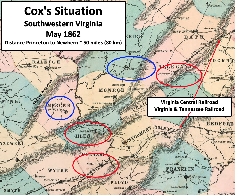
Cox hoped to sever the Confederate Virginia & Tennessee Railroad
Summary[edit]
| Description |
English: Map describes the situation in May 1862 in southwestern Virginia during the American Civil War. Cox had two of his three brigades near Princeton, and hoped to attack the Virginia and Tennessee Railroad. His Third Brigade, commanded by Colonel George Crook, was near Lewisburg and planned an attack on the Virginia Central Railroad further east. A Confederate regional headquarters was located at the Dublin railroad depot in Newbern (misspelled as "Newbert" on the map). |
| Date | |
| Source | This is a crop of an 1861 map created by O.N. Snow & Co. The entire map can be found in the Library of Congress here, and shows Virginia, Delaware, Maryland & West Virginia. Text box, circles, and arrows were added by TwoScarsUp based on descriptions in the books "The Battle of Lewisburg" by Richard L. Armstrong, "Military Reminiscences of the Civil War" by Jacob Dolson Cox, and "A History of Middle New River Settlements and Contiguous Territory" by David E. Johnston. |
| Author | O.N. Snow with modifications by TwoScarsUp |
Southwestern Virginia (portions later became West Virginia)
Licensing[edit]
|
This work is in the public domain in its country of origin and other countries and areas where the copyright term is the author's life plus 70 years or fewer. This work is in the public domain in the United States because it was published (or registered with the U.S. Copyright Office) before January 1, 1929. | |
| This file has been identified as being free of known restrictions under copyright law, including all related and neighboring rights. | |
File history
Click on a date/time to view the file as it appeared at that time.
| Date/Time | Thumbnail | Dimensions | User | Comment | |
|---|---|---|---|---|---|
| current | 16:01, 13 May 2022 | | 933 × 774 (1.35 MB) | TwoScarsUp (talk | contribs) | Uploaded a work by O.N. Snow with modifications by TwoScarsUp from This is a crop of an 1861 map created by O.N. Snow & Co. The entire map can be found in the Library of Congress [https://www.loc.gov/item/lva0000091/ here], and shows Virginia, Delaware, Maryland & West Virginia. Text box, circles, and arrows were added by TwoScarsUp based on descriptions in the books "The Battle of Lewisburg" by Richard L. Armstrong, "Military Reminiscences of the Civil War" by Jacob Dolson Cox, and "A Histo... |
You cannot overwrite this file.
File usage on Commons
There are no pages that use this file.
File usage on other wikis
The following other wikis use this file:
- Usage on en.wikipedia.org