File:Crete topographic map-uk.svg
Jump to navigation
Jump to search

Size of this PNG preview of this SVG file: 800 × 380 pixels. Other resolutions: 320 × 152 pixels | 640 × 304 pixels | 1,024 × 486 pixels | 1,280 × 608 pixels | 2,560 × 1,215 pixels | 3,370 × 1,600 pixels.
Original file (SVG file, nominally 3,370 × 1,600 pixels, file size: 2.6 MB)
Captions
Captions
Add a one-line explanation of what this file represents
| Description |
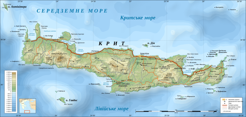
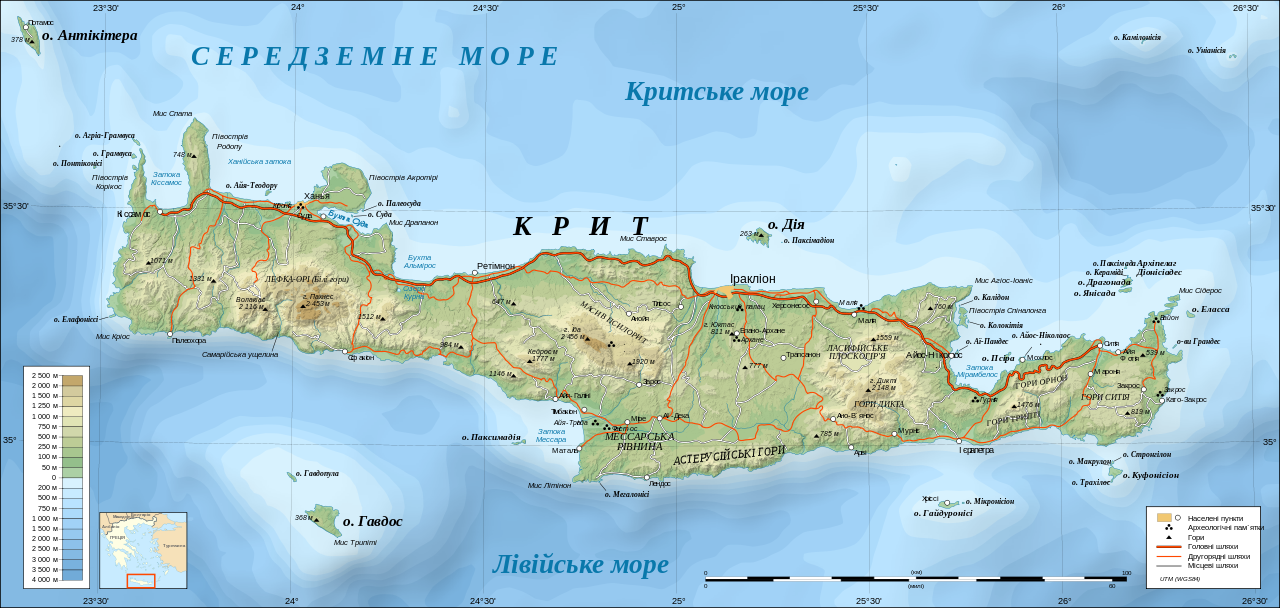
UTM projection; WGS84 datum; shaded relief (composite image of N-W, W and N lightning positions) Approximate scales: *Topographic data and shore / lakes limits: 1:400,000 (accuracy: about 100 m) ; *Bathymetry: 1:14,800,000 (accuracy: about 3,700 m) ; Note: The shaded relief is a raster image embedded in the SVG file. |
| Date | (UTC) |
| Source | |
| Author |
|
| Other versions |
[]
|


I, the copyright holder of this work, hereby publish it under the following licenses:
This file is licensed under the Creative Commons Attribution-Share Alike 3.0 Unported, 2.5 Generic, 2.0 Generic and 1.0 Generic license.
- You are free:
- to share – to copy, distribute and transmit the work
- to remix – to adapt the work
- Under the following conditions:
- attribution – You must give appropriate credit, provide a link to the license, and indicate if changes were made. You may do so in any reasonable manner, but not in any way that suggests the licensor endorses you or your use.
- share alike – If you remix, transform, or build upon the material, you must distribute your contributions under the same or compatible license as the original.

|
Permission is granted to copy, distribute and/or modify this document under the terms of the GNU Free Documentation License, Version 1.2 or any later version published by the Free Software Foundation; with no Invariant Sections, no Front-Cover Texts, and no Back-Cover Texts. A copy of the license is included in the section entitled GNU Free Documentation License. |
You may select the license of your choice.
Original upload log[edit]
This image is a derivative work of the following images:
- File:Crete_topographic_map-fr.svg licensed with Cc-by-sa-3.0,2.5,2.0,1.0, GFDL
- 2008-06-17T19:30:34Z Sting 3370x1600 (2728121 Bytes) Colors of bathymetry changed ; other modifications
- 2007-12-03T22:38:14Z Sting 3370x1600 (2211161 Bytes) 2 archaeological sites added
- 2007-12-02T14:08:56Z Sting 3370x1600 (2207333 Bytes) Slight text rendering improvements
- 2007-12-01T21:09:12Z Sting 3370x1600 (2215882 Bytes) {{Information |Description=Topographic map in French of [[:en:Crete|Crete island]], [[:en:Greece|Greece]] |Source=Own work ;Topography : [http://www2.jpl.nasa.gov/srtm NASA Shuttle Radar Topography Mission] (SRTM3 v.2) data (
Uploaded with derivativeFX
File history
Click on a date/time to view the file as it appeared at that time.
| Date/Time | Thumbnail | Dimensions | User | Comment | |
|---|---|---|---|---|---|
| current | 20:10, 12 August 2009 | | 3,370 × 1,600 (2.6 MB) | Dim Grits (talk | contribs) | Доповнення у перекладі. |
| 19:48, 12 August 2009 |  | 3,370 × 1,600 (2.6 MB) | Dim Grits (talk | contribs) | Переклад | |
| 19:29, 12 August 2009 |  | 3,370 × 1,600 (2.6 MB) | Dim Grits (talk | contribs) | Переклад. | |
| 18:47, 12 August 2009 |  | 3,370 × 1,600 (2.6 MB) | Dim Grits (talk | contribs) | Додавання перекладу. | |
| 18:23, 12 August 2009 |  | 3,370 × 1,600 (2.6 MB) | Dim Grits (talk | contribs) | {{Information |Description={{en|Topographic map in French of Crete island, Greece.}} {{fr|Carte topographique en français de l'île de Crète, Grèce.}}<br/> UTM projection; WGS84 datum; shaded |
You cannot overwrite this file.
File usage on Commons
The following 18 pages use this file:
- File:Crete archaeological sites-fr.svg
- File:Crete archaeological sites-pt.svg
- File:Crete integrated map-el.svg
- File:Crete integrated map-en.svg
- File:Crete integrated map-hu.svg
- File:Crete integrated map-mk.svg
- File:Crete integrated map-ur.svg
- File:Crete relief map-be.svg
- File:Crete relief map-de.jpg
- File:Crete relief map-de.svg
- File:Crete relief map-fr.svg
- File:Crete topographic map-fr.jpg
- File:Crete topographic map-fr.svg
- File:Crete topographic map-it.svg
- File:Crete topographic map-ru.svg
- File:Crete topographic map-uk.svg
- File:Minoan Crete topographic map-ru.svg
- Template:Other versions/Crete topographic map
File usage on other wikis
The following other wikis use this file: