File:Eastern Adriatic 1500.svg
Jump to navigation
Jump to search


Size of this PNG preview of this SVG file: 657 × 600 pixels. Other resolutions: 263 × 240 pixels | 526 × 480 pixels | 841 × 768 pixels | 1,122 × 1,024 pixels | 2,243 × 2,048 pixels | 1,920 × 1,753 pixels.
Original file (SVG file, nominally 1,920 × 1,753 pixels, file size: 7 MB)
Captions
Captions
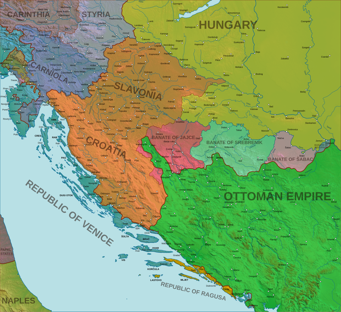
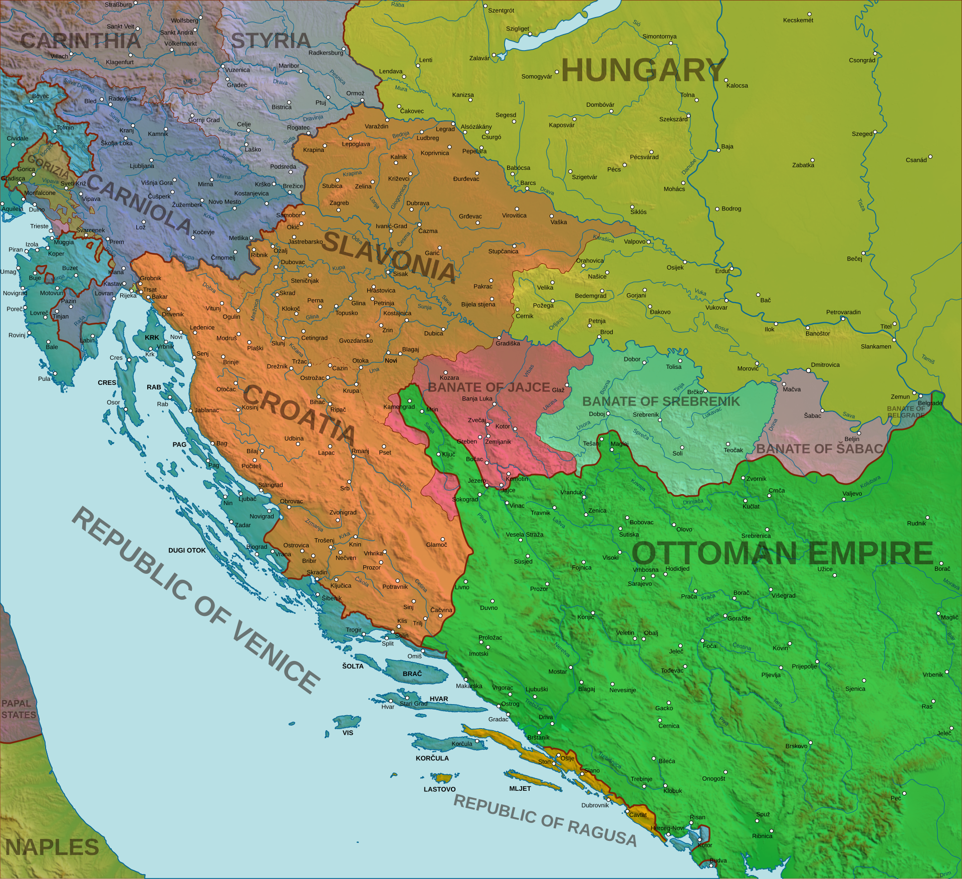
Croatian-Hungarian union, Venetian Dalmatia, Ottoman Bosnia in 1500
Summary[edit]
| Description |
English: Kingdom of Croatia, Kingdom of Hungary, Ottoman Empire, Archduchy of Austria (Duchies of Styria, Carinthia, and Carniola), Republic of Ragusa, and Republic of Venice in 1500. Trieste and Rijeka had an autonomous status. Croatia and Slavonia were since 1476 united under the same ban, but kept separate parliaments. |
| Date | |
| Source | Own work |
| Author | Relief image from File:Yugoslavia_topographic_base_map.svg |
References[edit]
- Dugački, Vlatka; Regan, Krešimir: Hrvatski povijesni atlas (Historical atlas of Croatia). Zagreb: Miroslav Krleža Institute of Lexicography, 2018. ISBN 9789532680454, pp. 172-173, 182-183, 337
- France M. Dolinar; Aleš Gabrič; Boris Golec; Miha Kosi; Tomaž Nabergoj; et al: Slovenski zgodovinski atlas (Slovenian Historical Atlas). Ljubljana: Nova revija, 2011. ISBN 9789616580892, pp. 99, 112
Licensing[edit]
I, the copyright holder of this work, hereby publish it under the following license:
This file is licensed under the Creative Commons Attribution-Share Alike 4.0 International license.
- You are free:
- to share – to copy, distribute and transmit the work
- to remix – to adapt the work
- Under the following conditions:
- attribution – You must give appropriate credit, provide a link to the license, and indicate if changes were made. You may do so in any reasonable manner, but not in any way that suggests the licensor endorses you or your use.
- share alike – If you remix, transform, or build upon the material, you must distribute your contributions under the same or compatible license as the original.
File history
Click on a date/time to view the file as it appeared at that time.
| Date/Time | Thumbnail | Dimensions | User | Comment | |
|---|---|---|---|---|---|
| current | 23:43, 11 April 2021 | | 1,920 × 1,753 (7 MB) | Tezwoo (talk | contribs) | a few new places, better visibility of borders |
| 23:39, 4 February 2021 |  | 1,920 × 1,753 (6.82 MB) | Tezwoo (talk | contribs) | Added one fort (Novi on Una River), a few minor changes | |
| 22:57, 16 January 2021 |  | 1,920 × 1,753 (6.81 MB) | Tezwoo (talk | contribs) | Uploaded own work with UploadWizard |
You cannot overwrite this file.
File usage on Commons
The following page uses this file:
File usage on other wikis
The following other wikis use this file:
- Usage on en.wikipedia.org
- Usage on es.wikipedia.org
- Usage on et.wikipedia.org
- Usage on fa.wikipedia.org
- Usage on ja.wikipedia.org
- Usage on mk.wikipedia.org
- Usage on zh.wikipedia.org