File:Cuenca-072-073-074-080-B.svg

Original file (SVG file, nominally 2,063 × 1,256 pixels, file size: 10.46 MB)
Captions
Captions
Summary
[edit]
| Description |
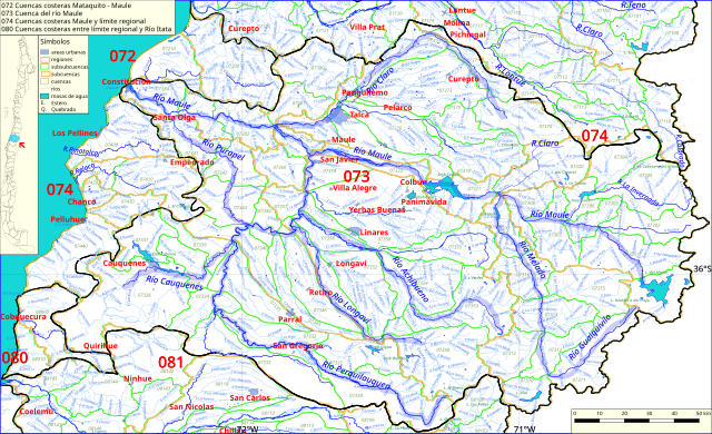
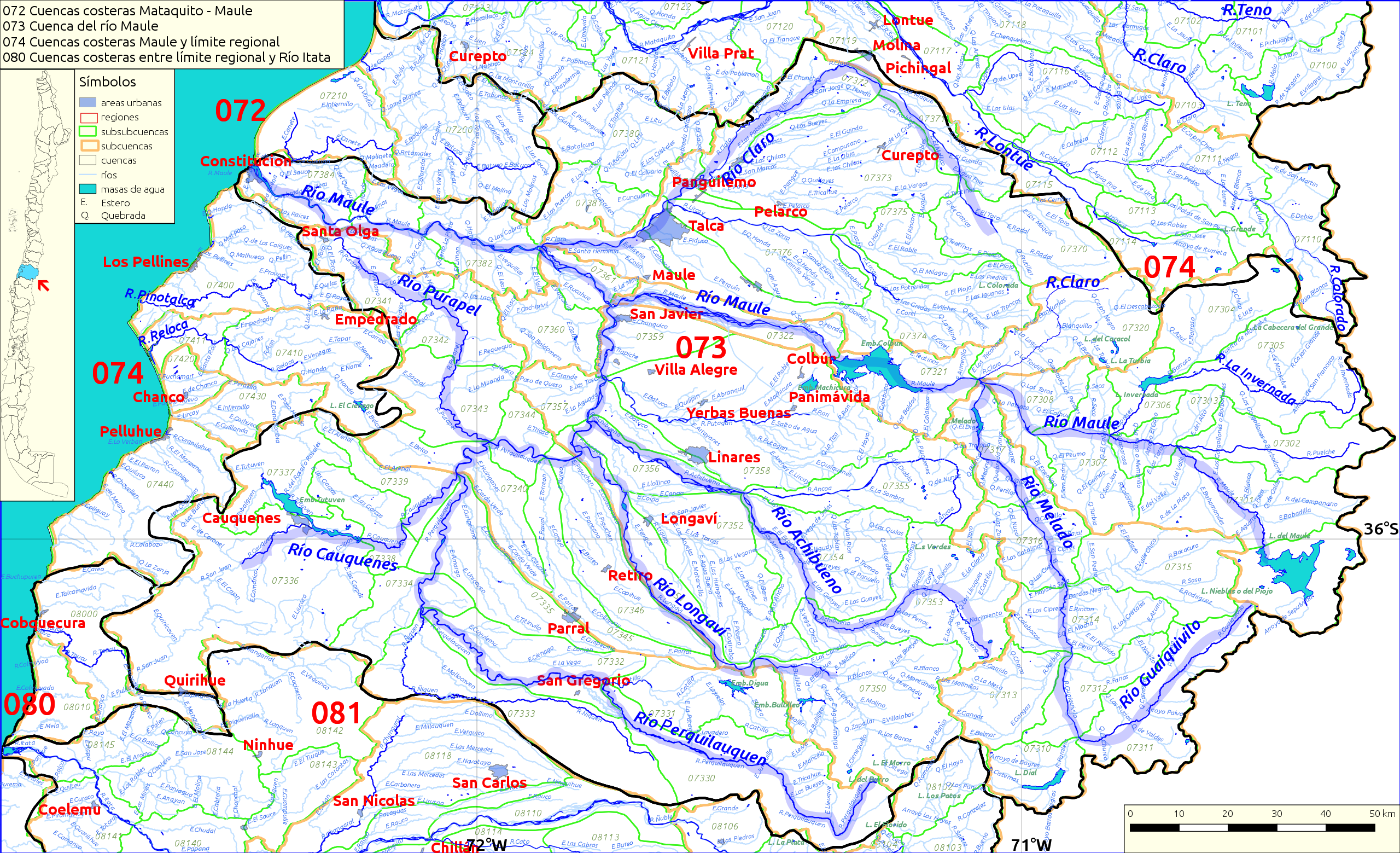
Español: Cuencas hidrográficas 072, 073 (río maule), 074 y 080 de Chile.
Este mapa se elaboró con información extraída de:
Donde BNC, MMA y cedeus significan:
Los datos fueron procesados con QGIS version 2.18.17, exportados al formato SVG con las opciones "render map labels as outlines" desconectada pero "export map layers as svg groups" conectada. Con Inkscape 0.92 se eliminó la excesiva repetición de nombres, los nombres fueron colocados paralelos a los ríos o lagos y en lugares más visibles. Nombres y números que el editor no pudo asociar a objeto alguno fueron borrados. Finalmente se redujo el volumen de datos por medio de svgo (svg-optimizer). |
| Date | |
| Source | Own work |
| Author | Juan Villalobos |
Licensing
[edit]
- You are free:
- to share – to copy, distribute and transmit the work
- to remix – to adapt the work
- Under the following conditions:
- attribution – You must give appropriate credit, provide a link to the license, and indicate if changes were made. You may do so in any reasonable manner, but not in any way that suggests the licensor endorses you or your use.
- share alike – If you remix, transform, or build upon the material, you must distribute your contributions under the same or compatible license as the original.
File history
Click on a date/time to view the file as it appeared at that time.
| Date/Time | Thumbnail | Dimensions | User | Comment | |
|---|---|---|---|---|---|
| current | 11:09, 17 December 2020 | | 2,063 × 1,256 (10.46 MB) | Juan Villalobos (talk | contribs) | corrijo pejerreyes --> Perquín, según mapa y diccionario de Luis Risopatrón. |
| 18:14, 11 December 2020 |  | 2,063 × 1,256 (10.46 MB) | Juan Villalobos (talk | contribs) | again, the same | |
| 18:07, 11 December 2020 |  | 2,063 × 1,256 (10.46 MB) | Juan Villalobos (talk | contribs) | Rio->R. , Estero ->E. , Lago, Laguna->L. , mar azul. No svgcleaner | |
| 10:14, 8 March 2019 |  | 2,063 × 1,256 (5.59 MB) | Juan Villalobos (talk | contribs) | corrijo: el río Catillo desagua en el Perquilauquen y no al revés. Borro "Catillo" tras la confluencia. svgcleaner | |
| 23:03, 6 March 2019 |  | 2,063 × 1,256 (5.59 MB) | Juan Villalobos (talk | contribs) | latitud, longitud, Estero-->E. , Quebrada--> Q. , reducido con svgcleaner | |
| 10:25, 1 February 2019 |  | 2,201 × 1,340 (6.15 MB) | Juan Villalobos (talk | contribs) | User created page with UploadWizard |
You cannot overwrite this file.
File usage on Commons
The following page uses this file:
File usage on other wikis
The following other wikis use this file:
- Usage on de.wikipedia.org
- Usage on es.wikipedia.org
- Río Maule
- Río Achibueno
- Río Loncomilla
- Río Longaví
- Río Perquilauquén
- Río Putagán
- Río Ancoa
- Río Purapel
- Río Cauquenes
- Complejo hidroeléctrico Colbún-Machicura
- Canal de Devolución Colbún
- Laguna El Blanquillo
- Río Claro (Talca)
- Canal Melozal
- Categoría:Cuenca del río Maule (073)
- Cuenca del río Maule
- Estero Los Puercos
- Embalse Bullileo
- Embalse Digua
- Embalse Tutuvén
- Estero Curipeumo
- Embalse Ancoa
- Río Tutuvén
- Santuario de la naturaleza del Cajón del río Achibueno
- Canal Maule (riego)
- Laguna Achibueno
- Laguna Amargo
- Embalse Empedrado
- Canal Perquilauquén-Ñiquen
- Río Blanco (Longaví)
- Río Liguay
- Río Bullilleo
- Tranque de relaves Las Palmas
- Baños de Catillo
- Baños de Longaví
- Baños Campanario
- Baños Maule
- Usage on he.wikipedia.org
- Usage on sh.wikipedia.org
- Usage on www.wikidata.org