File:Cuenca-123-B.svg

Original file (SVG file, nominally 1,153 × 1,524 pixels, file size: 2.8 MB)
Captions
Captions
Summary[edit]
| Description |
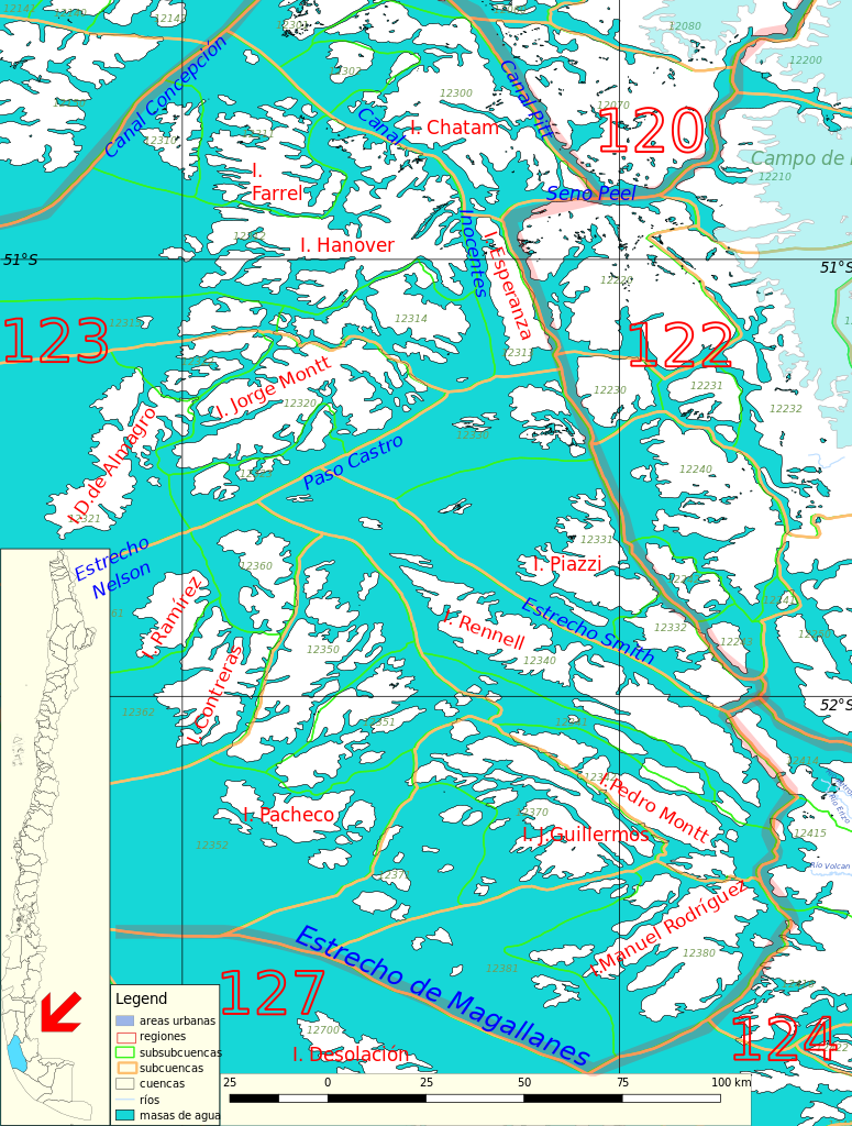
Español: Cuenca 123 del inventario de cuencas de Chile.
Este mapa se elaboró con información extraída de:
Donde BNC, MMA y cedeus significan:
Los datos fueron procesados con QGIS version 2.18.17, exportados al formato SVG con las opciones "render map labels as outlines" desconectada pero "export map layers as svg groups" conectada. Con Inkscape 0.92 se eliminó la excesiva repetición de nombres, los nombres fueron colocados paralelos a los ríos o lagos y en lugares más visibles. Nombres y números que el editor no pudo asociar a objeto alguno fueron borrados. Finalmente se redujo el volumen de datos por medio de svgo (svg-optimizer). |
| Date | |
| Source | Own work |
| Author | Juan Villalobos |
Licensing[edit]
- You are free:
- to share – to copy, distribute and transmit the work
- to remix – to adapt the work
- Under the following conditions:
- attribution – You must give appropriate credit, provide a link to the license, and indicate if changes were made. You may do so in any reasonable manner, but not in any way that suggests the licensor endorses you or your use.
- share alike – If you remix, transform, or build upon the material, you must distribute your contributions under the same or compatible license as the original.
File history
Click on a date/time to view the file as it appeared at that time.
| Date/Time | Thumbnail | Dimensions | User | Comment | |
|---|---|---|---|---|---|
| current | 10:49, 18 December 2022 | | 1,153 × 1,524 (2.8 MB) | Juan Villalobos (talk | contribs) | Islands names added |
| 22:15, 1 July 2019 |  | 1,153 × 1,524 (2.03 MB) | Juan Villalobos (talk | contribs) | svgcleaner, mar azul, grid | |
| 06:48, 26 June 2019 |  | 947 × 1,289 (1.93 MB) | Juan Villalobos (talk | contribs) | Reverted to version as of 13:19, 27 February 2019 (UTC) | |
| 09:55, 10 June 2019 |  | 2,232 × 1,724 (3.52 MB) | Juan Villalobos (talk | contribs) | WITHOUT svgcleaner because of "Error: invalid attribute value at 2677:156." mar azul. | |
| 13:19, 27 February 2019 |  | 947 × 1,289 (1.93 MB) | Juan Villalobos (talk | contribs) | "121" y "123" corridos hacia la derecha | |
| 13:16, 27 February 2019 |  | 947 × 1,289 (1.93 MB) | Juan Villalobos (talk | contribs) | {{Information |description ={{es|1=Cuenca 123 del inventario de cuencas de Chile.}} |date =2019-02-27 |source ={{own}} |author =Juan Villalobos }} Cuenca 123 del inventario de cuencas de Chile. Category:Maps of rivers of Chile (drainage basins BCN) |
You cannot overwrite this file.
File usage on Commons
There are no pages that use this file.
File usage on other wikis
The following other wikis use this file: