File:CumberlandSoundNunavutMap.png
پرش به ناوبری
پرش به جستجو
تفکیکپذیری بالاتری در دسترس نیست.
CumberlandSoundNunavutMap.png (۵۰۲ × ۴۳۲ پیکسل، اندازهٔ پرونده: ۱۶ کیلوبایت، نوع MIME پرونده: image/png)
گزینهها
عنوان
شرحی یکخطی از محتوای این فایل اضافه کنید
خلاصه[ویرایش]
| توضیح |
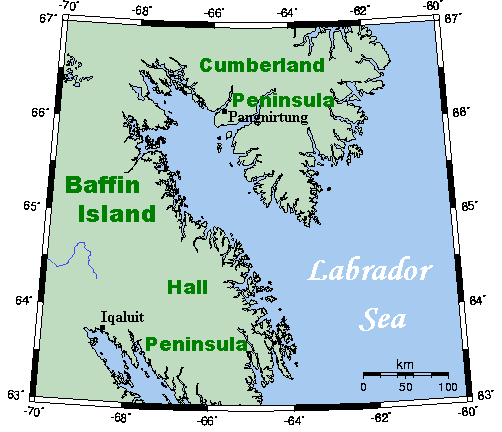
English: A map showing Cumberland Sound and nearby areas. This map's source is here, with the uploader's modifications, and the GMT homepage says that the tools are released under the GNU General Public License. |
| تاریخ | ۸ ژوئیهٔ ۲۰۰۷ (تاریخ اصلی بارگذاری) |
| منبع | Transferred from en.wikipedia |
| پدیدآور | Original uploader was Kelisi at en.wikipedia |
| اجازهنامه (استفادهٔ مجدد از این پرونده) |
Released under the GNU Free Documentation License. |
اجازهنامه[ویرایش]
Kelisi from en.wikipedia.org، صاحب حقوق قانونی این اثر، به این وسیله آن را تحت اجازهنامهٔ زیر منتشر میکند:
| این پرونده با اجازهنامهٔ کریتیو کامانز Attribution-Share Alike 3.0 سازگار نشده منتشر شده است. به تکذیبنامهها رجوع شود. | ||
| انتساب: Kelisi from en.wikipedia.org | ||
| ||
| این برچسب مجوز بهعنوان بخشی از روزآمدسازی مجوز GFDL، به این پرونده افزوده شد. |

|
اجازهٔ کپی، پخش و/یا تغییر این سند تحت شرایط مجوز مستندات آزاد گنو، نسخهٔ ۱٫۲ یا هر نسخهٔ بعدتری که توسط بنیاد نرمافزار آزاد منتشر شده؛ بدون بخشهای ناوردا (نامتغیر)، متون روی جلد، و متون پشت جلد، اعطا میشود. یک کپی از مجوز در بخشی تحت عنوان مجوز مستندات آزاد گنو ضمیمه شده است. به تکذیبنامهها رجوع شود. |
سیاهه بارگذاری اصلی[ویرایش]
صفحهٔ اصلی توضیحات اینجابود. همهٔ نامهای کاربر زیر به en.wikipedia اشاره دارند.
- 2007-07-08 15:12 Kelisi 502×432×8 (16196 bytes) Addition of Pang.
- 2007-07-08 01:31 Kelisi 501×432×8 (16018 bytes) so much for the U after Q rule.
- 2007-07-08 01:24 Kelisi 502×432×8 (16022 bytes) == Summary == A map showing Cumberland Sound and nearby areas. This map's source is [http://www.aquarius.geomar.de/omc/make_map.html here], with the uploader's modifications, and the [http://gmt.soest.hawaii.edu/ GMT homepage] says that the tools are rele
تاریخچهٔ پرونده
روی تاریخ/زمانها کلیک کنید تا نسخهٔ مربوط به آن هنگام را ببینید.
| تاریخ/زمان | بندانگشتی | ابعاد | کاربر | توضیح | |
|---|---|---|---|---|---|
| کنونی | ۱۲ ژوئیهٔ ۲۰۰۸، ساعت ۱۰:۰۷ | | ۵۰۲ در ۴۳۲ (۱۶ کیلوبایت) | Urdangaray (بحث | مشارکتها) | {{Information |Description={{en|A map showing Cumberland Sound and nearby areas. This map's source is [http://www.aquarius.ifm-geomar.de/ here], with the uploader's modifications, and the [http://gmt.soest.hawaii.edu/ GMT homepage] says that the tools are |
شما نمیتوانید این پرونده را رونویسی کنید.
کاربرد پرونده
این پرونده در هیچ صفحهای به کار نرفته است.
کاربرد سراسری پرونده
ویکیهای دیگر زیر از این پرونده استفاده میکنند:
- کاربرد در bg.wikipedia.org
- کاربرد در ckb.wikipedia.org
- کاربرد در da.wikipedia.org
- کاربرد در de.wikipedia.org
- کاربرد در en.wikipedia.org
- کاربرد در es.wikipedia.org
- کاربرد در fa.wikipedia.org
- کاربرد در fr.wikipedia.org
- کاربرد در pt.wikipedia.org
- کاربرد در ru.wikipedia.org
- کاربرد در www.wikidata.org