File:Dřevíkov, CZ180224-011.jpg
Jump to navigation
Jump to search

Size of this preview: 800 × 464 pixels. Other resolutions: 320 × 186 pixels | 640 × 371 pixels | 1,024 × 594 pixels | 1,280 × 742 pixels | 2,560 × 1,485 pixels | 4,623 × 2,681 pixels.
Original file (4,623 × 2,681 pixels, file size: 4.52 MB, MIME type: image/jpeg)
Captions
Captions
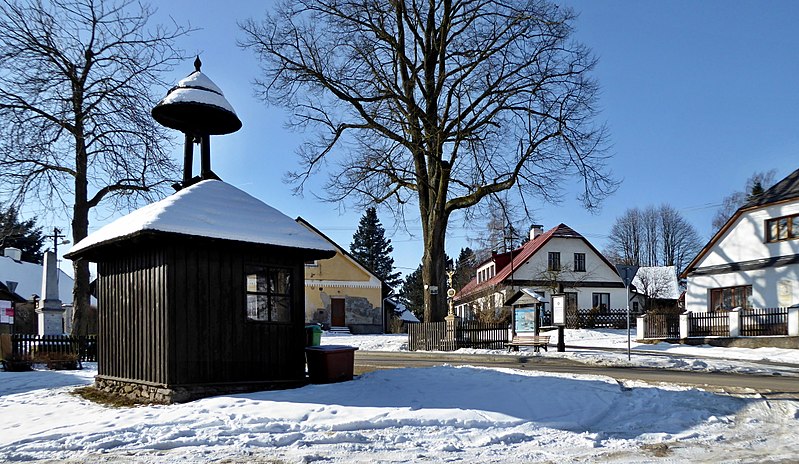
Buildings of traditional folk architecture, , the hamlet Dřevíkov in village in Vysočina, Czechia.
Summary[edit]
| Description |
English: "Dřevíkovská" village green, a wooden bell tower, also fulfills the function of a waiting room at the bus stop. In the photo on left the memorial to the victims of the wars 1914-1918 and 1939-1945 and on right the house with a memorial plaque dedicated to teacher and writer, to Czech patriot "František Hrnčíř" (1860–1928). On a tree (linden) above the road is a signpost of the tourist route of the Czech Tourists Club, also a small sacred structure, the so-called God's torture and the information board on the Homeland trail the Region of Chrudimka River (point 10 - "Dřevíkovská" village green). "Dřevíkov" is settlement locality of the type of small hamlet and the name of the cadastral area with an area of 226.58 ha with a range of approximately 534 to 579 meters above sea level in the landscape area of the Iron Mountains, within the administrative is part municipality of Vysočina in the district of Chrudim belonging to the Pardubice Region in the territory of the Czech Republic. Photo location: Czechia, Pardubice Region, municipality Vysočina, hamlet of "Dřevíkov", "Stružinecká" knoll hill.
Čeština: Dřevíkovská náves s dřevěnou zvoničkou (malá stavba slouží současně jako čekárna autobusové zastávky). Vlevo pomník obětem válek 1914–1918 a 1939–1945, vpravo dům s pamětní deskou věnovanou učiteli a spisovateli Františku Hrnčířovi (1860–1928), místnímu rodákovi a českému vlastenci. Na stromu (lípa) nad silnicí je rozcestník zeleně značené turistické trasy Klubu českých turistů (úsek Veselý Kopec – Dřevíkov – Svobodné Hamry), také malá sakrální stavba, tzv. Boží muka a informační tabule vlastivědné stezky Krajem Chrudimky (stanoviště č. 10 s názvem Dřevíkovská náves). Dřevíkov je sídelní lokalita typu vesnice a název katastrálního území o rozloze 226,58 ha s rozsahem poloh přibližně 534 až 579 m n. m. v krajinné oblasti Železných hor, v rámci administrativně správním část obce Vysočina v okrese Chrudim náležejícím do Pardubického kraje na území České republiky. Foto lokace: Česko, Pardubický kraj, obec Vysočina, vesnice Dřevíkov, Stružinecká pahorkatina (190°). |
| Date | |
| Source | Own work |
| Author | Josef Kreuz (PEPan) |
| Camera location | | View this and other nearby images on: OpenStreetMap |
|---|
Externí odkazy:[edit]
- Mapy.cz, turistická mapa (letecký pohled) – Dřevíkov viz
- Obec Vysočina – webové stránky viz
Licensing[edit]
I, the copyright holder of this work, hereby publish it under the following license:
This file is licensed under the Creative Commons Attribution-Share Alike 4.0 International license.
- You are free:
- to share – to copy, distribute and transmit the work
- to remix – to adapt the work
- Under the following conditions:
- attribution – You must give appropriate credit, provide a link to the license, and indicate if changes were made. You may do so in any reasonable manner, but not in any way that suggests the licensor endorses you or your use.
- share alike – If you remix, transform, or build upon the material, you must distribute your contributions under the same or compatible license as the original.
File history
Click on a date/time to view the file as it appeared at that time.
| Date/Time | Thumbnail | Dimensions | User | Comment | |
|---|---|---|---|---|---|
| current | 15:14, 24 February 2018 | | 4,623 × 2,681 (4.52 MB) | PEPan (talk | contribs) | User created page with UploadWizard |
You cannot overwrite this file.
File usage on Commons
There are no pages that use this file.
File usage on other wikis
The following other wikis use this file:
- Usage on cs.wikipedia.org
- Usage on fr.wikipedia.org