File:DF13 EUROPE.png
Прејди на прегледникот
Прејди на пребарувањето

Големина на овој преглед: 504 × 600 пиксели. Други разделности: 202 × 240 пиксели | 403 × 480 пиксели | 645 × 768 пиксели | 861 × 1.024 пиксели | 1.534 × 1.825 пиксели.
Изворна податотека (1.534 × 1.825 пиксели, големина: 166 КБ, MIME-тип: image/png)
Описи
Описи
Опишете во еден ред што претставува податотекава
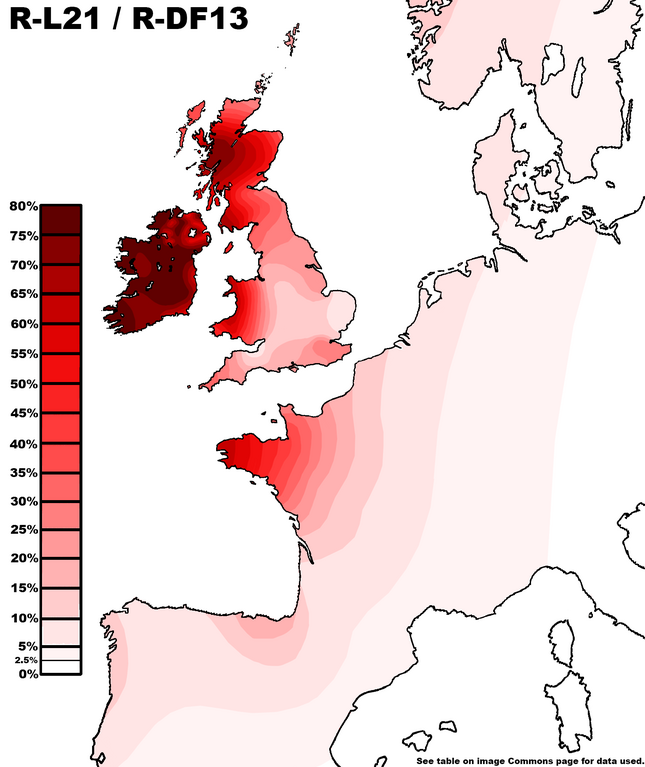
Distribution of Haplogroup R-DF13 in Europe.
Опис
[уреди]
| Опис |
English: Distribution of Haplogroup R-DF13 in Europe. Data derived from Figures provided in Familytreedna database via the Discover Feature under the country frequency table. Figures are higher than given directly by FamilyTreeDNA. This is because testers disappear between M343 and the downstream clades which contain all testers under M343 (Z2103, S1194, DF19, DF63, Z46516, U106, DF13). These clades are all checked as to their percentage persistence in the regions, and then their persistence is collectively multiplied by whatever decimal is necessary to reach the total M343 percentage persistence in the country. This is valid as there are no other clades under M343 which contain even one single tester in any of these regions, so the only reason a tester who is M343 is not classified under one of these clades is because their test contained insufficient data to do so. The same thing is done for data collected from projects. Unassigned R1bs are removed from the sample size to make it more accurate. See below table.
|
| Датум | |
| Извор | сопствено дело |
| Автор | SKIBLY101 |
| R-L21 Regional Persistence Data | ||
| Region | Sample Size | % |
|---|---|---|
| FamilyTreeDNA Discover™ Country Data | ||
| Republic of Ireland [note 1] | 8,100 | 70.0 |
| Ireland (Island) | 11,250 | 63.2 |
| Scotland | 7,996 | 48.9 |
| Northern Ireland | 1,567 | 48.2 |
| Wales | 1,080 | 43.5 |
| United Kingdom | 4,726 | 23.9 |
| England | 13,814 | 16.5 |
| France | 3,179 | 12.0 |
| Portugal | 806 | 7.0 |
| Norway | 1,973 | 6.1 |
| Belgium | 401 | 6.1 |
| Spain | 2,096 | 5.9 |
| Netherlands | 1,206 | 4.5 |
| Denmark | 711 | 4.2 |
| Sweden | 4,200 | 3.2 |
| Germany | 8,602 | 2.9 |
| Italy | 3,066 | 1.5 |
| FamilyTreeDNA Geographical Project Data | ||
| County Kerry Y-DNA Project | 140 | 82.0 |
| Kilkenny Surnames Geographic Project |
208 | 80.0 |
| County Roscommon, Ireland | 47 | 76.6 |
| Clare Roots | 705 | 75.0 |
| Greater Galway | 298 | 71.5 |
| Cork Ireland | 503 | 68.0 |
| Clans of Galloway | 113 | 56.5 |
| Bretagne/Brittany | 43 | 55.0 |
| Scots-Irish | 1,601 | 53.0 |
| Aberdeen & North East Scotland | 320 | 50.3 |
| Kintyre Roots | 181 | 50.0 |
| Manx Y-DNA Study | 111 | 46.2 |
| Isle of Lewis | 63 | 37.0 |
| Northumberland | 350 | 35.3 |
| Caithness & Sutherland (Counties) | 237 | 35.0 |
| CORNWALL ADVANCED YDNA | 186 | 30.6 |
| Orkney | 54 | 27.0 |
| Normandy Y-DNA | 91 | 24.0 |
| Shetland Islands | 148 | 22.2 |
| Wessex, England | 53 | 20.2 |
| Basque-DNA (Only counted those inside Basque region on project map) |
40 | 19.4 |
| Devon | 318 | 19.0 |
| Yorkshire | 151 | 18.4 |
| Lancashire | 101 | 14.7 |
| East Anglia | 357 | 9.5 |
| Palatine | 243 | 3.5 |
| Ireland yDNA Project Data (map used) | ||
| County Cavan | 44 | 80.9 |
| County Tipperary | 74 | 80.0 |
| County Mayo | 79 | 76.5 |
| County Limerick | 59 | 64.3 |
| County Dublin | 24 | 50.0 |
| Combined DNA Project and Ireland yDNA Project Data | ||
| County Wexford Ireland | 43 | 53.0 |
| British Isles by County Project Data | ||
| Middlesex | 77 | 33.6 |
| Kent | 46 | 30.0 |
| Herefordshire, Shropshire | 24 | 29.0 |
| Lincolnshire, Leicestershire, Nottinghamshire |
71 | 22.3 |
| Sussex | 39 | 20.9 |
| Lancashire | 66 | 20.6 |
| East Lothian, Mid Lothian, West Lothian, Lanarkshire |
54 | 19.8 |
| Dorsetshire, Wiltshire, Hampshire, Berkshire |
63 | 19.1 |
| Gloucestershire, Warwickshire, Worcestshire, Staffordshire |
98 | 17.7 |
| Cheshire | 29 | 16.5 |
| Derbyshire | 24 | 16.4 |
| Northamptonshire, Buckinghamshire, Bedford, Hertfordshire, Huntingdonshire, Cambridgeshire |
87 | 14.4 |
| Somersetshire | 42 | 9.0 |
| Scottish Y-DNA Project Data | ||
| Skye | 23 | 66.0 |
| Uist | 26 | 34.5 |
Notes
[уреди]
- ↑ 'Republic of Ireland' total not included in FTDNA Discovery Database but is synthetically calculated using:
- If you observe the members results chart for the Ulster geographic DNA projects: "Ulster Heritage DNA", "Scots-Irish" and "North of Ireland", you will observe that there is a ratio averagely of about 1:2 for members with their 'Country' (the delineation that FTDNA's data on the Discovery feature cites) set to 'Northern Ireland' or 'Ireland' respectively, when referring to ancestors born within the modern borders of the state of Northern Ireland.
- With this figure in mind we can calculate the influence of users with their Country marked as 'Ireland' with ancestors from within the modern boundaries of Northern Ireland (using the respective % for both regions), and remove them from the former's total, calculating the percentage otherwise, so that the two political regions can be compared directly.
Лиценцирање
[уреди]
Јас, праводржецот на ова дело, со ова го објавувам истото под следнава лиценца:
Оваа податотека е под лиценцата Криејтив комонс Наведи извор-Сподели под исти услови 4.0 Меѓународна.
- Можете:
- да споделите – да го умножувате, распространувате и емитувате делото
- да преработувате – да преработувате
- Под следните услови:
- наведи извор – Ќе мора да дадете прикладен припис, да ставите врска до лиценцата и да укажете дали има направено промени. Ова може да биде направено на било кој разумен начин, но без да оддава впечаток дека лиценцодавецот стои зад Вас и Вашата употреба.
- сподели под исти услови – Ако го измените или преобразите делото, или пак ако основате друго дело на него, добиеното дело (придонесот) морате да го распространувате (објавувате) само под истата или складна лиценца на изворната.
Историја на податотеката
Стиснете на датум/време за да ја видите податотеката како изгледала тогаш.
| Датум/време | Минијатура | Димензии | Корисник | Коментар | |
|---|---|---|---|---|---|
| тековна | 01:08, 30 ноември 2023 | | 1.534 × 1.825 (166 КБ) | SKIBLY101 (разговор | придонеси) | update |
| 17:06, 22 октомври 2023 |  | 1.534 × 1.825 (171 КБ) | Skibly113 (разговор | придонеси) | update | |
| 18:59, 19 октомври 2023 |  | 1.534 × 1.825 (172 КБ) | Skibly113 (разговор | придонеси) | update | |
| 18:43, 19 октомври 2023 |  | 1.534 × 1.825 (172 КБ) | Skibly113 (разговор | придонеси) | update | |
| 00:18, 19 октомври 2023 |  | 1.534 × 1.825 (173 КБ) | Skibly113 (разговор | придонеси) | update | |
| 13:57, 18 октомври 2023 |  | 1.534 × 1.825 (174 КБ) | Skibly113 (разговор | придонеси) | update | |
| 00:15, 18 октомври 2023 |  | 1.534 × 1.825 (174 КБ) | Skibly113 (разговор | придонеси) | update | |
| 21:15, 16 октомври 2023 |  | 1.534 × 1.825 (174 КБ) | Skibly113 (разговор | придонеси) | update | |
| 15:55, 15 октомври 2023 |  | 1.534 × 1.825 (174 КБ) | Skibly113 (разговор | придонеси) | update | |
| 01:23, 15 октомври 2023 |  | 1.534 × 1.825 (172 КБ) | Skibly113 (разговор | придонеси) | update |
Не можете да презапишете врз податотекава.
Употреба на податотеката
Податотекава се користи во следнава страница:
Глобална употреба на податотеката
Оваа податотека ја користат и следниве викија:
- Употреба на en.wikipedia.org
- Употреба на mk.wikipedia.org