File:DOE NNSA Fukushima Survey March 24 and 26.PNG
跳至導覽
跳至搜尋

預覽大小:776 × 600 像素。 其他解析度:311 × 240 像素 | 621 × 480 像素 | 780 × 603 像素。
原始檔案 (780 × 603 像素,檔案大小:548 KB,MIME 類型:image/png)
說明
說明
添加單行說明來描述出檔案所代表的內容
摘要
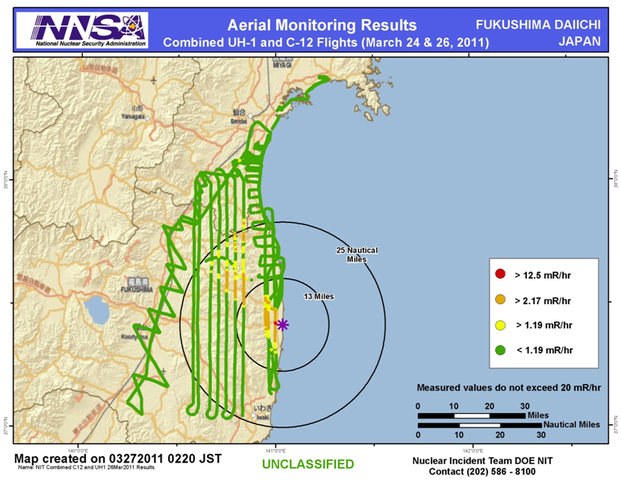
[編輯]| 描述 | Aerial survey by the US DOE and NNSA, in cooperation with the DoD, using their equipment and air force bases in Japan. Main site for the work. It is the belief of the uploader that the website clearly indicates that the image is exclusively the work of US federal agencies for which the marked license applies. |
| 日期 | |
| 來源 | http://energy.gov/news/documents/AMS_Data_March29_FINAL.pptx |
| 作者 | 未知 |
| 其他版本 |
|


授權條款
[編輯]
| 此圖像是美國能源部(或前身組織)的僱員於其公務中所作之作品。由於此作品由美國聯邦政府所作,其處於公有領域。
請注意美國國家實驗室使用不同授權條款而其中部分為自由條款。檢查實驗室的網站政策後才可使用此標籤。
|

|
檔案歷史
點選日期/時間以檢視該時間的檔案版本。
| 日期/時間 | 縮圖 | 尺寸 | 用戶 | 備註 | |
|---|---|---|---|---|---|
| 目前 | 2011年3月31日 (四) 14:06 | | 780 × 603(548 KB) | Theanphibian(對話 | 貢獻) | {{Information |Description ={{en|1=== Summary == {{Information |Description ={{en|1=Aerial survey by the US DOE and NNSA, in cooperation with the DoD, using their equipment and air force bases in Japan. [http://blog.energy.gov/content/situation-jap |
無法覆蓋此檔案。
檔案用途
下列9個頁面有用到此檔案:
- File:Contamination Fukushima.jpg
- File:DOE NNSA Fukushima Survey March 17-19.png
- File:DOE NNSA Fukushima Survey March 17.PNG
- File:DOE NNSA Fukushima Survey March 24.PNG
- File:DOE NNSA Fukushima Survey March 24 and 26.PNG
- File:DOE NNSA Fukushima Survey March 27-28.PNG
- File:NIT Combined Flights Ground Measurements 30Mar 03Apr2011 results.jpg
- File:NNSA DOE Dose Map Fukushima.png
- Template:Fukushima DOE NNSA gallery
全域檔案使用狀況
以下其他 wiki 使用了這個檔案:
- de.wikipedia.org 的使用狀況
- en.wikipedia.org 的使用狀況
- it.wikipedia.org 的使用狀況
- zh.wikipedia.org 的使用狀況