File:DPF Angles-18.jpg
Jump to navigation
Jump to search
No higher resolution available.
DPF_Angles-18.jpg (576 × 514 pixels, file size: 31 KB, MIME type: image/jpeg)
Captions
Captions
Add a one-line explanation of what this file represents
Summary[edit]

|
This diagram image could be re-created using vector graphics as an SVG file. This has several advantages; see Commons:Media for cleanup for more information. If an SVG form of this image is available, please upload it and afterwards replace this template with
{{vector version available|new image name}}.
It is recommended to name the SVG file “DPF Angles-18.svg”—then the template Vector version available (or Vva) does not need the new image name parameter. |


| Description |
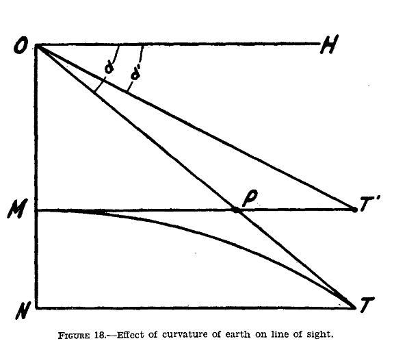
English: Diagram, illustrating sides and angles involved in measuring range with a Depression Position Finder (DPF) instrument, |
| Date | |
| Source | From "FM 4-15: Coast Artillery Field Manual, Seacoast Artillery Fire Control and Position Finding", War Department, U.S. Government Printing Office, Washington, 1940, p. 47. |
| Author | US War Department |
Licensing[edit]
This work is in the public domain in the United States because it is a work prepared by an officer or employee of the United States Government as part of that person’s official duties under the terms of Title 17, Chapter 1, Section 105 of the US Code.
Note: This only applies to original works of the Federal Government and not to the work of any individual U.S. state, territory, commonwealth, county, municipality, or any other subdivision. This template also does not apply to postage stamp designs published by the United States Postal Service since 1978. (See § 313.6(C)(1) of Compendium of U.S. Copyright Office Practices). It also does not apply to certain US coins; see The US Mint Terms of Use.
|
 | |
| This file has been identified as being free of known restrictions under copyright law, including all related and neighboring rights. | ||
Original upload log[edit]
Transferred from en.wikipedia to Commons using For the Common Good.
The original description page was here. All following user names refer to en.wikipedia.
| Date/Time | Dimensions | User | Comment |
|---|---|---|---|
| 14:52, 6 June 2010 | 576 × 514 (31,511 bytes) | w:en:Pgrig (talk | contribs) | Diagram, illustrating sides and angles involved in measuring range with a Depression Range Finder (DPF), is taken from "FM 4-15: Coast Artillery Field Manual, Seacoast Artillery Fire Control and Position Finding, War Department, U.S. Government Printing O |
File history
Click on a date/time to view the file as it appeared at that time.
| Date/Time | Thumbnail | Dimensions | User | Comment | |
|---|---|---|---|---|---|
| current | 10:44, 26 March 2020 | | 576 × 514 (31 KB) | Andy Dingley (talk | contribs) | Transferred from en.wikipedia: see original upload log above |
You cannot overwrite this file.
File usage on Commons
There are no pages that use this file.
File usage on other wikis
The following other wikis use this file:
- Usage on en.wikipedia.org