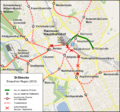
File:D Entwurf der Region 2012 nach Verzicht auf den Abriss der Raschplatz-Hochstraße.png
From Wikimedia Commons, the free media repository
Jump to navigation
Jump to search

Size of this preview: 642 × 600 pixels. Other resolutions: 257 × 240 pixels | 514 × 480 pixels | 822 × 768 pixels | 1,104 × 1,031 pixels.
Original file (1,104 × 1,031 pixels, file size: 1 MB, MIME type: image/png)
File information
Structured data
Captions
Captions
Add a one-line explanation of what this file represents
Summary[edit]
| DescriptionD Entwurf der Region 2012 nach Verzicht auf den Abriss der Raschplatz-Hochstraße.png |
Deutsch: Ausbau D-Strecke Innenstadt: Entwurf der Region von 2012, angepasst nach Verzicht auf den Abriss der Raschplatz-Hochstraße. |
| Date | |
| Source | Self made with OSM Data. |
| Author | Pechristener |
| Permission (Reusing this file) |
Map data (c) OpenStreetMap (and) contributors, CC-BY-SA |
| Other versions |
|
Licensing[edit]
This file is licensed under the Creative Commons Attribution-Share Alike 2.0 Generic license.
- You are free:
- to share – to copy, distribute and transmit the work
- to remix – to adapt the work
- Under the following conditions:
- attribution – You must give appropriate credit, provide a link to the license, and indicate if changes were made. You may do so in any reasonable manner, but not in any way that suggests the licensor endorses you or your use.
- share alike – If you remix, transform, or build upon the material, you must distribute your contributions under the same or compatible license as the original.
File history
Click on a date/time to view the file as it appeared at that time.
| Date/Time | Thumbnail | Dimensions | User | Comment | |
|---|---|---|---|---|---|
| current | 20:08, 13 December 2016 |  | 1,104 × 1,031 (1 MB) | Pechristener (talk | contribs) | Tunnelstrecke vom Hauptbahnhof zur Werderstraße / Anpassung Bereich Kopernikusstraße |
| 16:12, 12 December 2016 |  | 1,104 × 1,031 (1 MB) | Pechristener (talk | contribs) | (zuerst falsche Datei hochgeladen) | |
| 15:45, 12 December 2016 |  | 2,192 × 1,501 (2.4 MB) | Pechristener (talk | contribs) | Korrekturen: Es muss heißen Leibniz Universität (statt "Leibnitz") Bei Clevertor fehlt das "aufzuhebende Haltestelle"-Symbol Der sog. "Posttunnel" ist Teil der Lister Meile und sollte daher auch so bezeichnet werden. Wenn Platz da ist, könnte man ("... | |
| 05:22, 27 December 2014 |  | 1,104 × 1,031 (1,020 KB) | Pechristener (talk | contribs) | User created page with UploadWizard |
You cannot overwrite this file.
File usage on Commons
The following 15 pages use this file:
- User:Chumwa/OgreBot/Potential transport maps/2016 December 11-20
- User:Chumwa/OgreBot/Public transport information/2014 December 21-31
- User:Chumwa/OgreBot/Public transport information/2016 December 11-20
- User:Chumwa/OgreBot/Transport Maps/2014 December 21-31
- User:Chumwa/OgreBot/Transport Maps/2016 December 11-20
- User:Chumwa/OgreBot/Travel and communication maps/2016 December 11-20
- User:Liesel/Rail transport/2014 December 21-31
- User:Nordlicht8/Rail Germany/2014 December 21-31
- File:D Entwurf der Region 2012.png
- File:D Oberirdisch.png
- File:D Tunnel 1960er Jahre.png
- File:D Tunnel 1990er Jahre.png
- File:D Tunnel 1990er Jahre - Zoo.png
- File:D Tunnel 2008.png
- File:D Tunnel 2008 Var B.png
File usage on other wikis
The following other wikis use this file:
- Usage on de.wikipedia.org
Metadata
This file contains additional information such as Exif metadata which may have been added by the digital camera, scanner, or software program used to create or digitize it. If the file has been modified from its original state, some details such as the timestamp may not fully reflect those of the original file. The timestamp is only as accurate as the clock in the camera, and it may be completely wrong.
| Short title |
|
|---|---|
| Horizontal resolution | 55.12 dpc |
| Vertical resolution | 55.12 dpc |
| Software used |


