File:Damrey 2017 track.png
Pumunta sa nabigasyon
Pumunta sa paghahanap
Laki ng pasilip na ito: 800 x 495 na pixel. Ibang resolusyon: 320 x 198 na pixel | 640 x 396 na pixel | 1,024 x 633 na pixel | 1,280 x 791 na pixel | 2,700 x 1,669 na pixel.
Orihinal na file (2,700 × 1,669 na pixel, laki: 3.02 MB, uri ng MIME: image/png)
Captions
Captions
Add a one-line explanation of what this file represents
Buod
| Paglalarawan |
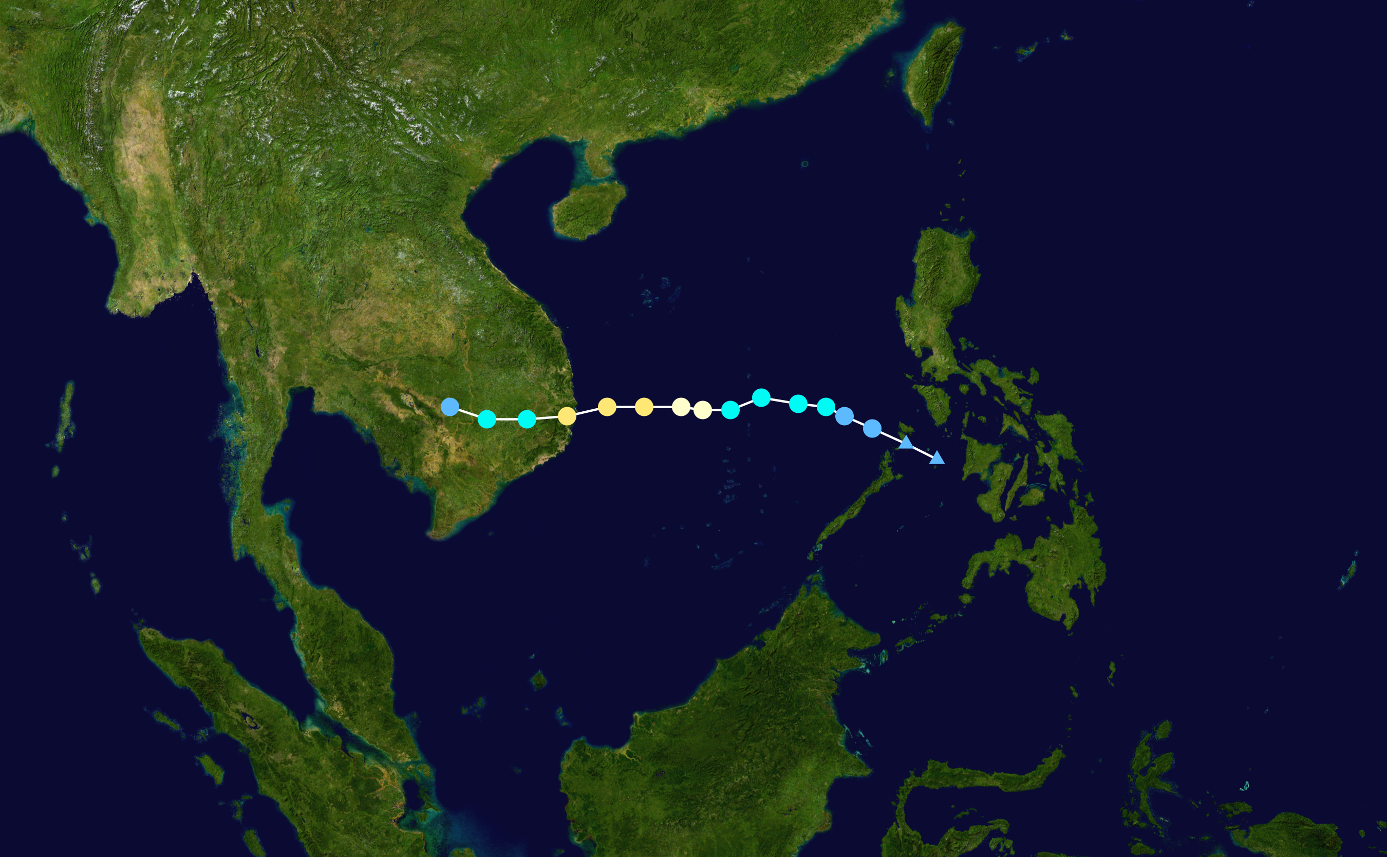
English: Track map of Typhoon Damrey of the 2017 Pacific typhoon season. The points show the location of the storm at 6-hour intervals. The colour represents the storm's maximum sustained wind speeds as classified in the (see below), and the shape of the data points represent the nature of the storm, according to the legend below. Tropical depression (≤38 mph, ≤62 km/h)
Tropical storm (39–73 mph, 63–118 km/h)
Category 1 (74–95 mph, 119–153 km/h)
Category 2 (96–110 mph, 154–177 km/h)
Category 3 (111–129 mph, 178–208 km/h)
Category 4 (130–156 mph, 209–251 km/h)
Category 5 (≥157 mph, ≥252 km/h)
Unknown
Storm type |
||
| Petsa | 2017-11-01–2017-11-05 | ||
| Pinanggalingan | Created by Meow using Wikipedia:WikiProject Tropical cyclones/Tracks. The background image is from NASA. Tracking data is from the Joint Typhoon Warning Center[1]. | ||
| May-akda | Meow | ||
| Source code | Track map data table, if present below, is in HURDAT2 or ATCF format. See format details in [2] and [3], respectively.
|
Paglilisensiya[baguhin]
| Ang akdang ito ay pinakawalan sa sakop ng madla ng may-akda nito, si Meow. Magagamit ito sa buong daigdig. Maaaring hindi ito posibleng legal sa ilang mga bansa; kung ganito: Ibinibigay ni Meow kaninuman ang karapatang gamitin ang akdang ito para sa anumang layunin, na walang anumang kundisyon, maliban na lamang kung ang ganyang mga kundisyon ay kinakailangan sa batas. |
Nakaraan ng file
Pindutin ang isang petsa/oras para makita ang file noong puntong yon.
| Petsa/Oras | Thumbnail | Sukat | Tagagamit | Komento | |
|---|---|---|---|---|---|
| ngayon | 00:55, 24 Enero 2020 | | 2,700 × 1,669 (3.02 MB) | Supportstorm (usapan | ambag) | JTWC data |
| 23:14, 21 Abril 2019 |  | 2,700 × 1,669 (3.15 MB) | Supportstorm (usapan | ambag) | IBTrACS version | |
| 14:04, 6 Nobyembre 2017 |  | 2,700 × 1,669 (2.96 MB) | Meow (usapan | ambag) | 11-05 00Z (operationally final) | |
| 14:29, 4 Nobyembre 2017 |  | 2,700 × 1,669 (2.92 MB) | Meow (usapan | ambag) | 11-04 12Z | |
| 14:14, 3 Nobyembre 2017 |  | 2,700 × 1,669 (2.79 MB) | Meow (usapan | ambag) | 11-03 12Z | |
| 13:42, 2 Nobyembre 2017 |  | 2,700 × 1,669 (2.67 MB) | Meow (usapan | ambag) | {{Current}} {{WPTC track map | author = Meow | name = Tropical Storm Damrey | article = 2017 Pacific typhoon season#Tropical Storm Damrey (Ramil) | season = 2017 Pacific typhoon season | start = 2017-10-31 | end = | othersource=[http://ftp.emc.... |
Hindi mo mao-overwrite ang file na ito.
Paggamit sa file
Ginagamit ng sumusunod na pahina ang file na ito:
Pandaigdigang paggamit sa file
Ginagamit ng mga sumusunod na wiki ang file na ito:
- Paggamit sa bcl.wikipedia.org
- Paggamit sa cs.wikipedia.org
- Paggamit sa en.wikipedia.org
- Paggamit sa ja.wikipedia.org
- Paggamit sa ko.wikipedia.org
- Paggamit sa pt.wikipedia.org
- Paggamit sa ru.wikipedia.org
- Paggamit sa th.wikipedia.org
- Paggamit sa tl.wikipedia.org
- Paggamit sa vi.wikipedia.org
- Paggamit sa www.wikidata.org
- Paggamit sa zh.wikipedia.org