File:Danewerk Luftbild1983.jpg
Jump to navigation
Jump to search

Size of this preview: 763 × 600 pixels. Other resolutions: 305 × 240 pixels | 611 × 480 pixels.
Original file (800 × 629 pixels, file size: 629 KB, MIME type: image/jpeg)
Captions
Captions
Add a one-line explanation of what this file represents
Summary
[edit]
| Description |
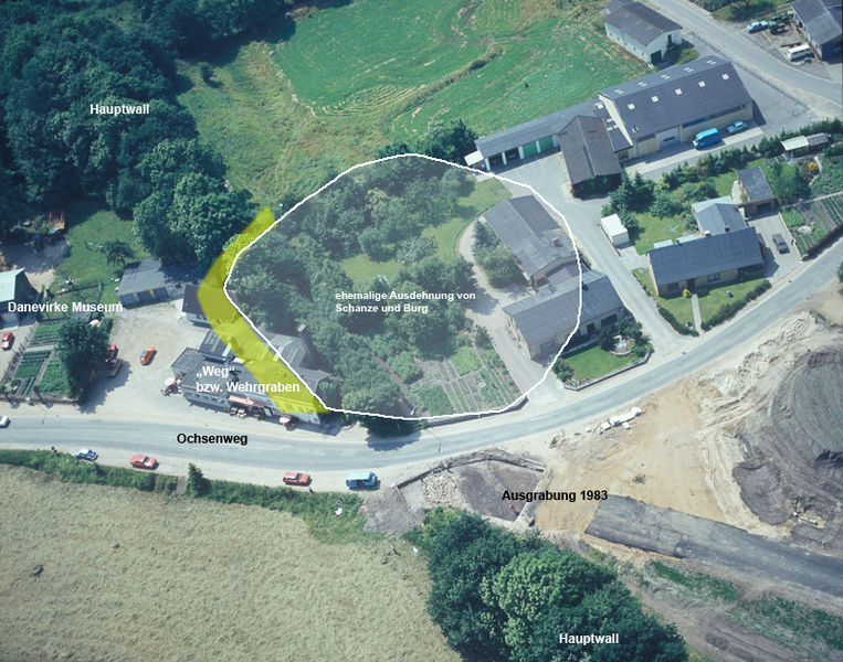
Deutsch: Ausgrabungstelle 2010–2014 (gelb) und Ausgrabungstelle 1983 (unten rechts) in Kleindannewerk, Luftaufnahme (rechts ist Norden). Die Fläche ehemalige Ausdehnung von Schanze und Burg entspricht einer Theorie von Willi Kramer. (Willi Kramer: Schanze und Burg bei Rothenkrug, Klein Dannewerk. In: Beiträge zur Schleswiger Stadtgeschichte 60, 2015.) |
| Date | |
| Source | Willi Kramer |
| Author | Willi Kramer |
| Permission (Reusing this file) |
Licensing
[edit]
This file is licensed under the Creative Commons Attribution-Share Alike 3.0 Germany license.
- You are free:
- to share – to copy, distribute and transmit the work
- to remix – to adapt the work
- Under the following conditions:
- attribution – You must give appropriate credit, provide a link to the license, and indicate if changes were made. You may do so in any reasonable manner, but not in any way that suggests the licensor endorses you or your use.
- share alike – If you remix, transform, or build upon the material, you must distribute your contributions under the same or compatible license as the original.

File history
Click on a date/time to view the file as it appeared at that time.
| Date/Time | Thumbnail | Dimensions | User | Comment | |
|---|---|---|---|---|---|
| current | 09:47, 12 November 2015 | | 800 × 629 (629 KB) | Cromarelli (talk | contribs) | {{Information |Description ={{de|1=Luftaufnahme mit Blick nach Osten auf ehemaliges Café Truberg. Gelb markiert der angebliche "Weg" zum "Wikingertor".}} |Source =Willi Kramer |Author =Willi Kramer |Date =1983-07-12 |Permi... |
You cannot overwrite this file.
File usage on Commons
There are no pages that use this file.
File usage on other wikis
The following other wikis use this file:
- Usage on da.wikipedia.org
- Usage on de.wikipedia.org