File:Darcha Padum Road Below Shinku La Lahaul Oct22 A7C 03533.jpg
跳转到导航
跳转到搜索

本预览的尺寸:800 × 533像素。 其他分辨率:320 × 213像素 | 640 × 427像素 | 1,024 × 683像素 | 1,280 × 853像素 | 2,560 × 1,707像素 | 6,000 × 4,000像素。
原始文件 (6,000 × 4,000像素,文件大小:20.05 MB,MIME类型:image/jpeg)
说明
说明
添加一行文字以描述该文件所表现的内容
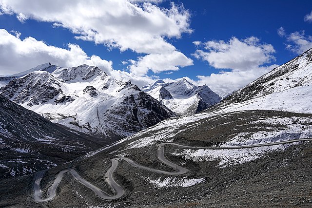
Darcha-Padum road winding up to Shinku La, Lahaul, Himachal, India. Elev. 4,975m (16,322'). 4 Oct 2022
摘要
[编辑]| 描述 |
English: Darcha-Padum road winding up to Shinku La, Lahaul, Himachal, India. Elev. 4,975m (16,322'). Peaks about 5,600m (18,375').
Español: El sinuoso camino a Shingo La, un paso montañoso del Himalaya de 5090 m de altura en el norte de India, que conecta la región de Lahaul en Himachal Pradesh con la región de Zanskar en Ladakh.
Українська: Звивиста дорога до Шінго Ла, гімалайського гірського перевалу висотою 5091 м на півночі Індії, що з’єднує регіон Лахаул у Гімачал-Прадеші з регіоном Занскар у Ладакху. |
|||
| 日期 | ||||
| 来源 | 自己的作品 | |||
| 作者 |
|

| 相机位置 | | 在以下服务上查看本图像和附近其他图像: OpenStreetMap |
|---|
评价
[编辑]
|
This image was selected as picture of the day on Wikimedia Commons for 6 October 2023. It was captioned as follows: English: The winding road to Shingo La, a 5,090 m (16,700 ft) Himalayan mountain pass in northern India connecting the Lahaul region of Himachal Pradesh with the Zanskar region of Ladakh. Other languages:
Čeština: Klikatící se horská silnice k horskému přechodu Shingo La v nadmořské výšce 5 090 m n. m. v himálajské části severní Indie spojuje oblast Lahaul and Spiti district a Ladak. Deutsch: Die Straße zum Shingo La, einem 5.090 m hohen Gebirgspass im Himalaya. English: The winding road to Shingo La, a 5,090 m (16,700 ft) Himalayan mountain pass in northern India connecting the Lahaul region of Himachal Pradesh with the Zanskar region of Ladakh. Español: El sinuoso camino a Shingo La, un paso montañoso del Himalaya de 5090 m de altura en el norte de India, que conecta la región de Lahaul en Himachal Pradesh con la región de Zanskar en Ladakh. Français : Route sinueuse de l'Himalaya menant vers le passage de Shingo La situé à 5 090 m, et reliant le district de Lahaul et Spiti à Zanskar, en Inde. Magyar: Kanyargós út a Singo Lán, az 5090 méter magas himalájai hágón Észak-Indiában, amely a Himácsal Prades tartománybeli Lahaul régiót köti össze a ladaki Zanszkár régióval Nederlands: Haarspeldbochten in de weg naar Shingo La, een bergpas op 5090 meter hoogte die Lahul en Zanskar in het noorden van India met elkaar verbindt Português: Estrada sinuosa para Shingo La, uma passagem de 5 090 m na montanha do Himalaia, no norte da Índia, que conecta a região de Lahaul, em Himachal Pradesh, com a região de Zanskar, em Ladakh. Slovenščina: Vijugasta cesta do Šingo Laja, 5090 metrov visokega himalajskega gorskega prelaza na severu Indije, ki povezuje pokrajino Lahaul v Himačal Pradešu s pokrajino Zanskar v Ladaku. Українська: Звивиста дорога до Шінго Ла, гімалайського гірського перевалу висотою 5091 м на півночі Індії, що з’єднує регіон Лахаул у Гімачал-Прадеші з регіоном Занскар у Ладакху. বাংলা : উইন্ডিং রাস্তা থেকে লিঙ্গো লা, উত্তর ভারতের 5,090 m (16,700 ft) বিস্তৃত হিমালায়ন গিরিপথ, যা লাদাখের জান্সকার অঞ্চলের সাথে হিমাচল প্রদেশের লাহৌল অঞ্চলকে সংযুক্ত করেছে। |
许可协议
[编辑]
我,本作品著作权人,特此采用以下许可协议发表本作品:
本文件采用知识共享署名-相同方式共享 4.0 国际许可协议授权。
- 您可以自由地:
- 共享 – 复制、发行并传播本作品
- 修改 – 改编作品
- 惟须遵守下列条件:
- 署名 – 您必须对作品进行署名,提供授权条款的链接,并说明是否对原始内容进行了更改。您可以用任何合理的方式来署名,但不得以任何方式表明许可人认可您或您的使用。
- 相同方式共享 – 如果您再混合、转换或者基于本作品进行创作,您必须以与原先许可协议相同或相兼容的许可协议分发您贡献的作品。
文件历史
点击某个日期/时间查看对应时刻的文件。
| 日期/时间 | 缩略图 | 大小 | 用户 | 备注 | |
|---|---|---|---|---|---|
| 当前 | 2022年10月18日 (二) 05:07 | | 6,000 × 4,000(20.05 MB) | Tagooty(留言 | 贡献) | Uploaded own work with UploadWizard |
您不可以覆盖此文件。
文件用途
以下38个页面使用本文件:
- Himachal Pradesh
- User:Andrew J.Kurbiko/POTD/2023
- User:Kacamata/Favorites
- User:UnpetitproleX/POTD
- User:Velopilger/2022, 18. Oktober
- User:Yasir72.multan/POTD Year
- User talk:Tagooty/Archive of User talk:Tagooty 13 Aug 2023 to 30 Nov 2023
- User talk:Tagooty/Archive of User talk:Tagooty 17 Oct 2022 to 31 Mar 2023
- Commons:Featured picture candidates/File:Darcha Padum Road Below Shinku La Lahaul Oct22 A7C 03533.jpg
- Commons:Featured picture candidates/Log/October 2022
- Commons:Featured pictures/Places/Other
- Commons:Featured pictures/chronological/2022-B
- Commons:Featured pictures/chronological/October 2022
- Commons:Files used on the AARoads Wiki/22
- Commons:Picture of the Year/2022/Candidates
- Commons:Picture of the Year/2022/R1/Gallery/2022-B
- Commons:Picture of the Year/2022/R1/Gallery/ALL
- Commons:Picture of the Year/2022/R1/Gallery/M10
- Commons:Picture of the Year/2022/R1/Gallery/Nature views
- Commons:Picture of the Year/2022/R1/v/Darcha Padum Road Below Shinku La Lahaul Oct22 A7C 03533.jpg
- Commons:Quality images/Subject/Places/Natural structures/archive 2022
- Commons:Quality images candidates/Archives October 22 2022
- File:Darcha Padum Road Below Shinku La Lahaul Oct22 A7C 03533.jpg
- Template:Potd/2023-10
- Template:Potd/2023-10-06
- Template:Potd/2023-10-06 (cs)
- Template:Potd/2023-10-06 (de)
- Template:Potd/2023-10-06 (en)
- Template:Potd/2023-10-06 (es)
- Template:Potd/2023-10-06 (fr)
- Template:Potd/2023-10-06 (hu)
- Template:Potd/2023-10-06 (mk)
- Template:Potd/2023-10-06 (myv)
- Template:Potd/2023-10-06 (nl)
- Template:Potd/2023-10-06 (pt)
- Template:Potd/2023-10-06 (sl)
- Template:Potd/2023-10-06 (uk)
- Category:Nimmu–Padum–Darcha road
全域文件用途
以下其他wiki使用此文件:
- alt.wikipedia.org上的用途
- av.wikipedia.org上的用途
- bn.wikipedia.org上的用途
- cv.wikipedia.org上的用途
- de.wikipedia.org上的用途
- en.wikipedia.org上的用途
- Mountain pass
- Wikipedia:WikiProject Highways
- Shingo La
- Wikipedia:Featured pictures/Places/Others
- Wikipedia:WikiProject Military history/Showcase
- Wikipedia:WikiProject Military history/Showcase/FP
- Wikipedia:WikiProject India/Recognized content
- Wikipedia:WikiProject India/Main page featured content
- Wikipedia:WikiProject Highways/Recognized content
- Wikipedia:WikiProject Military history/Indian military history task force
- Wikipedia:WikiProject Military history/Featured content
- User:Tagooty
- User talk:Tagooty
- India–China Border Roads
- Nimmu–Padum–Darcha road
- Portal:History/Recognized content
- Portal:India/Recognized content
- Wikipedia:WikiProject Mountains/Recognized content
- User talk:UnpetitproleX
- Wikipedia:Picture of the day/May 2023
- Wikipedia:Featured pictures thumbs/75
- Wikipedia:Featured picture candidates/December-2022
- Wikipedia:Featured picture candidates/Shingo La road
- Wikipedia:Wikipedia Signpost/2023-01-16/Featured content
- Wikipedia:Wikipedia Signpost/Single/2023-01-16
- Template:POTD/2023-05-04
- User:UnpetitproleX/POTD
- Wikipedia:Main Page history/2023 May 4
- Wikipedia:Main Page history/2023 May 4b
- et.wikipedia.org上的用途
- hu.wikipedia.org上的用途
- it.wiktionary.org上的用途
- kk.wikipedia.org上的用途
- ko.wikipedia.org上的用途
- lez.wikipedia.org上的用途
- mk.wikipedia.org上的用途
- os.wikipedia.org上的用途
- pt.wikipedia.org上的用途
- ru.wikipedia.org上的用途
- sah.wikipedia.org上的用途
- sv.wikipedia.org上的用途
- te.wikipedia.org上的用途
- uk.wikipedia.org上的用途
查看此文件的更多全域用途。