File:DarnestownAndSeneca.png
Jump to navigation
Jump to search
No higher resolution available.
DarnestownAndSeneca.png (607 × 558 pixels, file size: 103 KB, MIME type: image/png)
Captions
Captions
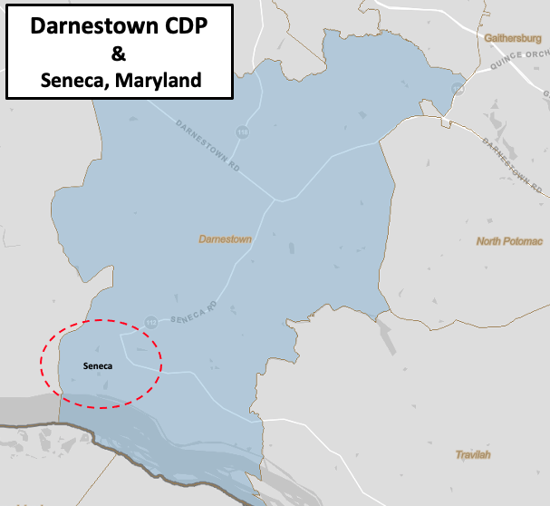
Seneca is a small part of the Darnestown Census-designated place
Summary[edit]
| Description |
English: This is a map of the Darnestown census-designated place as defined by the US Census Bureau for 2010 that also shows the approximate area of the subset Seneca populated place. |
| Date | |
| Source | This file came from the US Census here. It has been modified with a label and circle by TwoScarsUp |
| Author | United States Census |
Licensing[edit]
This work is in the public domain in the United States because it is a work prepared by an officer or employee of the United States Government as part of that person’s official duties under the terms of Title 17, Chapter 1, Section 105 of the US Code.
Note: This only applies to original works of the Federal Government and not to the work of any individual U.S. state, territory, commonwealth, county, municipality, or any other subdivision. This template also does not apply to postage stamp designs published by the United States Postal Service since 1978. (See § 313.6(C)(1) of Compendium of U.S. Copyright Office Practices). It also does not apply to certain US coins; see The US Mint Terms of Use.
|
 | |
| This file has been identified as being free of known restrictions under copyright law, including all related and neighboring rights. | ||
File history
Click on a date/time to view the file as it appeared at that time.
| Date/Time | Thumbnail | Dimensions | User | Comment | |
|---|---|---|---|---|---|
| current | 15:08, 20 July 2021 | | 607 × 558 (103 KB) | TwoScarsUp (talk | contribs) | Uploaded a work by United States Census from This file came from the US Census [https://data.census.gov/cedsci/map?q=Darnestown,%20CDP,%20Maryland&g=1600000US2421825&tid=ACSDP5Y2018.DP05&layer=VT_2018_160_00_PY_D1&vintage=2018&cid=DP05_0001E here]. It has been modified with a label and circle by TwoScarsUp with UploadWizard |
You cannot overwrite this file.
File usage on Commons
There are no pages that use this file.
File usage on other wikis
The following other wikis use this file:
- Usage on en.wikipedia.org