File:Daunengraben Lerchenberg Fuchtberg NSG GueltlingerHolzbronnerHeiden.jpg
Jump to navigation
Jump to search

Size of this preview: 800 × 162 pixels. Other resolutions: 320 × 65 pixels | 640 × 130 pixels | 1,024 × 208 pixels | 1,280 × 259 pixels | 2,560 × 519 pixels | 20,745 × 4,205 pixels.
Original file (20,745 × 4,205 pixels, file size: 97.1 MB, MIME type: image/jpeg)
Captions
Captions
Add a one-line explanation of what this file represents
Summary
[edit]
| Warning | The original file is very high-resolution. It might not load properly or could cause your browser to freeze when opened at full size. |
|---|
| Description |
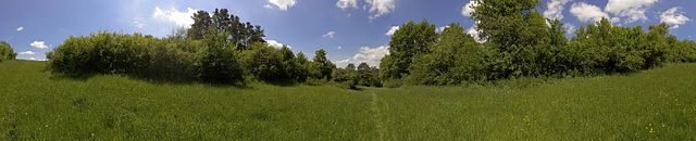
Deutsch: Der Blick nach Westen von der Hochfläche von Lerchenberg (links) und Fuchtberg (rechts) in den dazwischenliegenden Daunengraben im Naturschutzgebiet 'Gültlinger und Holzbronner Heiden'. Die Schlehenhecken zu beiden Seiten, die artenreiche Wiese dazwischen und die Waldkiefern im Hintergrund sind exemplarisch für die kleinteilige Landschaft im Naturschutzgebiet. |
| Date | |
| Source | Own work |
| Author | Gunnar Arndt |
| Camera location | | View this and other nearby images on: OpenStreetMap |
|---|
Licensing
[edit]
I, the copyright holder of this work, hereby publish it under the following license:
This file is licensed under the Creative Commons Attribution-Share Alike 4.0 International license.
- You are free:
- to share – to copy, distribute and transmit the work
- to remix – to adapt the work
- Under the following conditions:
- attribution – You must give appropriate credit, provide a link to the license, and indicate if changes were made. You may do so in any reasonable manner, but not in any way that suggests the licensor endorses you or your use.
- share alike – If you remix, transform, or build upon the material, you must distribute your contributions under the same or compatible license as the original.
This image was uploaded as part of Wiki Loves Earth 2016.
|
 |
File history
Click on a date/time to view the file as it appeared at that time.
| Date/Time | Thumbnail | Dimensions | User | Comment | |
|---|---|---|---|---|---|
| current | 22:17, 26 May 2016 | 20,745 × 4,205 (97.1 MB) | Madenhacker (talk | contribs) | User created page with UploadWizard |
You cannot overwrite this file.
File usage on Commons
The following page uses this file: