File:Day2otlk fire sep 6.gif
Jump to navigation
Jump to search
Size of this preview: 800 × 545 pixels. Other resolutions: 320 × 218 pixels | 640 × 436 pixels | 815 × 555 pixels.
Original file (815 × 555 pixels, file size: 27 KB, MIME type: image/gif)
Captions
Captions
Add a one-line explanation of what this file represents
Summary
[edit]
| Description |
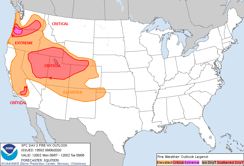
English: ZCZC SPCFWDDY2 ALL
FNUS22 KWNS 061959 Day 2 Fire Weather Outlook NWS Storm Prediction Center Norman OK 0259 PM CDT Sun Sep 06 2020 Valid 071200Z - 081200Z ...EXTREMELY CRITICAL FIRE WEATHER AREA FOR PARTS OF NORTHWEST OREGON FROM THE CASCADES TO THE COASTAL RANGES... ...CRITICAL FIRE WEATHER AREA FOR EASTERN WASHINGTON TO NORTHWESTERN OREGON FROM THE COLUMBIA BASIN TO THE OREGON SHORELINE... ...CRITICAL FIRE WEATHER AREA FOR MUCH OF THE CENTRAL AND EASTERN GREAT BASIN INTO THE CENTRAL ROCKIES... ...CRITICAL FIRE WEATHER AREA FOR SOUTHERN CALIFORNIA ALONG THE LEE OF THE SANTA YNEZ AND TEHACHAPI MOUNTAINS... An Extremely Critical risk was added for parts of northwest Oregon, encompassing the Coastal Ranges to the western slopes of the Cascades. Global/regional models and high-resolution guidance depict unseasonably strong offshore flow from roughly 06-12Z Monday night/Tuesday morning, supported by a strong pressure gradient associated with an approaching surface cold front and passing mid-level wind maximum. Easterly winds gusting to 50+ mph and RH dropping below 20% will foster very favorable wildfire-spread conditions given very dry fuels between the Coastal Ranges/Cascades (ERCs exceeding the 90th percentile in spots). A Critical area was also added for areas in close proximity to the Santa Ynez/Tehachapi Mountain Ranges. During the late afternoon/early evening hours, a tightening pressure gradient along with boundary-layer mixing/downslope flow are expected to contribute to 20-25 mph northwesterly surface winds amidst critically low RH per consensus of the latest regional/high-resolution guidance. From central California to central Oregon, surface northwesterly winds are expected to remain somewhat weaker compared to areas farther east-northeast, in closer proximity to a deepening trough aloft. Nonetheless, while an Elevated area remains in place, locally critical conditions may occur, especially by afternoon peak heating. The Elevated area across the Four Corners was extended into parts of the southern High Plains, where 15 mph westerly winds and 15-20% RH may occur by afternoon peak heating, and where the finer fuels are marginally supportive of fire spread. Otherwise, the forecast remains on track for the Great Basin into the central Rockies, and for the Pacific Northwest (outside of the Extremely Critical Risk area). Please see the previous forecast for more details involving the Great Basin/Inter-mountain West areas. ..Squitieri.. 09/06/2020 .PREV DISCUSSION... /ISSUED 0130 AM CDT Sun Sep 06 2020/ ...Synopsis... A large-scale pattern shift will continue to unfold across the western U.S. D2/Mon as a vigorous mid/upper trough digs southward across the interior West and a ridge initially over the western Great Basin weakens and retreats westward. Additionally, a very strong surface ridge will build southward across the northern Rockies as surface lows remain located along the West Coast, near the Lower Colorado River Valley, and across New Mexico. The resultant pressure gradient will set up an abnormally strong offshore flow regime across the Pacific Northwest along with areas of very strong surface flow across dry areas of the Great Basin. The overall pattern requires broad areas of elevated to critical fire weather highlights encompassing much of the western U.S. ...Northern Oregon and southern Washington State... The aforementioned synoptic setup will foster development of a significant offshore flow pattern across the region that will result in strong easterly surface winds throughout the forecast period. Wind speeds will likely exceed 30 mph in most areas, with gusts perhaps exceeding 50 mph especially in terrain-favored areas. Low RH values (around 15-25%) and very dry fuels across the region will support rapidly spreading fires potentially exhibiting extreme behavior. Poor overnight recovery and continued strong surface winds will result in fire-weather threats continuing through the overnight hours as well. ...Much of Nevada eastward into northwestern Colorado... The combination of strengthening flow aloft and a tightening pressure gradient will result in broad areas of 20-35 mph surface winds - especially within the critical delineation encompassing these regions through peak heating hours. Meanwhile, insolation (especially away from any clouds or precipitation near the region) will result in very warm surface temperatures (reaching the 90s F) and low RH values falling into the single digits. Winds near the approaching cold front (across Idaho/northern Nevada) will shift to northerly and remain strong (around or above 20 mph) overnight, which may complicate any ongoing fire suppression efforts in these areas. ...California... Much of the state will remain displaced from any direct influence from the approaching mid/upper trough across the northern Rockies. However, tightening of the surface pressure gradient across the state may combine with localized terrain influences to promote elevated to locally critical fire-weather at times. Most interior areas will remain very warm and dry, with afternoon RH values falling 7-15% and fuels remaining very dry across the state. The overall regime will support continued plume-dominated fire activity along with localized fire spread where surface winds can increase due to terrain. ...Please see www.spc.noaa.gov/fire for graphic product... CLICK FOR DAY 2 FIREWX AREAL OUTLINE PRODUCT (KWNSPFWFD2)
|
| Date | |
| Source | https://www.spc.noaa.gov/products/fire_wx/fwdy2.html |
| Author | NWS Storm Prediction Center Norman OK |
Licensing
[edit]
This file is licensed under the Creative Commons Attribution-Share Alike 4.0 International license.
- You are free:
- to share – to copy, distribute and transmit the work
- to remix – to adapt the work
- Under the following conditions:
- attribution – You must give appropriate credit, provide a link to the license, and indicate if changes were made. You may do so in any reasonable manner, but not in any way that suggests the licensor endorses you or your use.
- share alike – If you remix, transform, or build upon the material, you must distribute your contributions under the same or compatible license as the original.
File history
Click on a date/time to view the file as it appeared at that time.
| Date/Time | Thumbnail | Dimensions | User | Comment | |
|---|---|---|---|---|---|
| current | 03:00, 7 September 2020 | | 815 × 555 (27 KB) | Someguyt (talk | contribs) | Uploaded a work by NWS Storm Prediction Center Norman OK from https://www.spc.noaa.gov/products/fire_wx/fwdy2.html with UploadWizard |
You cannot overwrite this file.
File usage on Commons
There are no pages that use this file.