File:De Fer Partie Occidentale d'Afrique 1701 UTA.jpg
Jump to navigation
Jump to search
Size of this preview: 800 × 565 pixels. Other resolutions: 320 × 226 pixels | 640 × 452 pixels | 1,024 × 723 pixels | 1,280 × 904 pixels | 2,560 × 1,807 pixels | 3,146 × 2,221 pixels.
Original file (3,146 × 2,221 pixels, file size: 5.05 MB, MIME type: image/jpeg)
Captions
Captions
Add a one-line explanation of what this file represents
Summary[edit]
| Title |
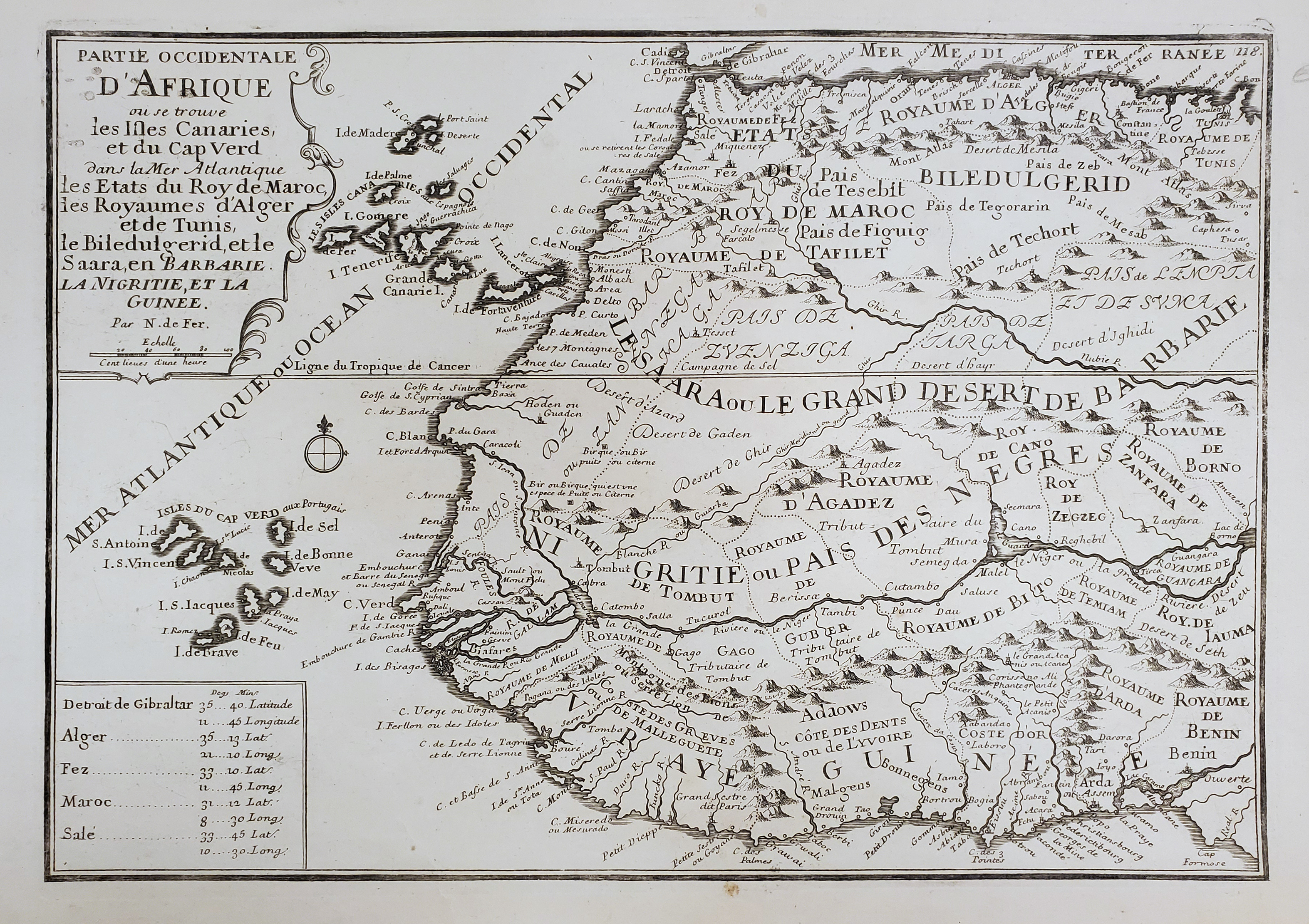
Français : Partie Occidentale d'Afrique out se trouve les Isles Canaries et du Cap Verd dans la Mer Atlantique les Etats du Roy de Maroc, les Royaumes d'Alger et de Tunis, le Biledulgerid et le Saara en Barbarie, La Nigritie, et la Guinee |
||||||||||||||||||||||||||
| Date | |||||||||||||||||||||||||||
| Source | UTA Libraries Cartographic Connections: map / text | ||||||||||||||||||||||||||
| Creator |
|
||||||||||||||||||||||||||
| Credit line |
English: UTA Libraries Special Collections, Gift of Dr. Jack Franke |
||||||||||||||||||||||||||
| Geotemporal data | |||||||||||||||||||||||||||
| Map location | West Africa | ||||||||||||||||||||||||||
| Georeferencing | If inappropriate please set warp_status = skip to hide. | ||||||||||||||||||||||||||
| Bibliographic data | |||||||||||||||||||||||||||
| Publication |
Cartes et Descriptions Generales et Particulieres pour Intelligence des Affaires du Temps au Sujet du Succession de la Couronne d 'Espagne, en Europe, en Asie, Afrique, et Amerique |
||||||||||||||||||||||||||
| Author |
|
||||||||||||||||||||||||||
| Place of publication | Paris | ||||||||||||||||||||||||||
| Printed by |
|
||||||||||||||||||||||||||
| Archival data | |||||||||||||||||||||||||||
| Collection |
|
||||||||||||||||||||||||||
| Medium | engraving on paper | ||||||||||||||||||||||||||

Licensing[edit]

|
This file was provided to Wikimedia Commons by the University of Texas at Arlington Libraries as part of a cooperation project. The University of Texas at Arlington Libraries is part of the University of Texas at Arlington, a public research university located in Arlington, Texas.
|
|
The author died in 1720, so this work is in the public domain in its country of origin and other countries and areas where the copyright term is the author's life plus 100 years or fewer. This work is in the public domain in the United States because it was published (or registered with the U.S. Copyright Office) before January 1, 1929. | |
| This file has been identified as being free of known restrictions under copyright law, including all related and neighboring rights. | |
File history
Click on a date/time to view the file as it appeared at that time.
| Date/Time | Thumbnail | Dimensions | User | Comment | |
|---|---|---|---|---|---|
| current | 18:15, 4 January 2022 | | 3,146 × 2,221 (5.05 MB) | Michael Barera (talk | contribs) | == {{int:filedesc}} == {{Map |title = ''Partie Occidentale d'Afrique out se trouve les Isles Canaries et du Cap Verd dans la Mer Atlantique les Etats du Roy de Maroc, les Royaumes d'Alger et de Tunis, le Biledulgerid et le Saara en Barbarie, La Nigritie, et la Guinee'' |description = |legend = |author = {{Creator:Nicolas de Fer}} |date = 1701 |source = UTA Libraries ''Cartographic Connections'': [https://libguides.uta.edu/... |
You cannot overwrite this file.
File usage on Commons
The following page uses this file: