File:Death Valley NP master map.png
跳转到导航
跳转到搜索
本预览的尺寸:546 × 599像素。 其他分辨率:219 × 240像素 | 437 × 480像素 | 853 × 936像素。
原始文件 (853 × 936像素,文件大小:951 KB,MIME类型:image/png)
说明
说明
添加一行文字以描述该文件所表现的内容
摘要
[编辑]
| 描述 |
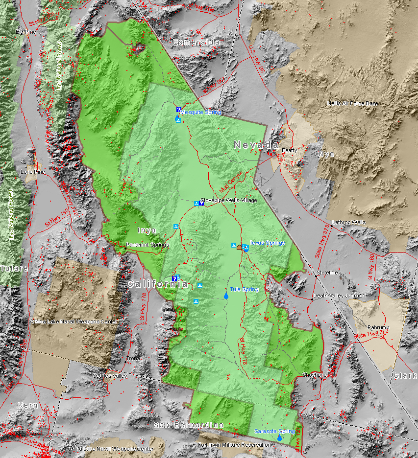
English: Map of the Death Valley National Park showing surrounding area and the previous smaller extent of the Park. Red dots are mine sites, blue triangles are camp sites, and blue question marks are tourist information facilities. This map also shows the old borders of Death Valley National Monument and the new borders of the expanded national park.
Français : Carte du parc et de ses environs.
Magyar: A nemzeti park térképe.
עברית: מפת הפארק הלאומי עמק המוות.
Български: В зелено са отбелязани границите на днешната Долина на смъртта. |
| 来源 | Map created by Daniel Mayer using data from the National Park Service metadata |
| 作者 | user:maveric149 (Daniel Mayer) |
| 授权 (二次使用本文件) |
我,本作品著作权人,特此采用以下许可协议发表本作品: 本文件采用知识共享署名-相同方式共享 2.5 通用许可协议授权。
|
文件历史
点击某个日期/时间查看对应时刻的文件。
| 日期/时间 | 缩略图 | 大小 | 用户 | 备注 | |
|---|---|---|---|---|---|
| 当前 | 2009年1月1日 (四) 21:59 | | 853 × 936(951 KB) | Mahahahaneapneap(留言 | 贡献) | Compressed |
| 2006年3月9日 (四) 01:30 |  | 853 × 936(1.22 MB) | Mav(留言 | 贡献) | Map created by Daniel Mayer using data from the National Park Service [http://science.nature.nps.gov/nrdata/metadata.cfm?ID=16872 metadata] |
您不可以覆盖此文件。
文件用途
以下2个页面使用本文件:
全域文件用途
以下其他wiki使用此文件:
- bg.wikipedia.org上的用途
- de.wikipedia.org上的用途
- en.wikipedia.org上的用途
- eu.wikipedia.org上的用途
- fa.wikipedia.org上的用途
- fr.wikipedia.org上的用途
- Parc national de la vallée de la Mort
- Wikipédia:Lumière sur/Mars 2005
- Wikipédia:Lumière sur/Février 2007
- Wikipédia:Lumière sur/Août 2007
- Wikipédia:Lumière sur/Parc national de la vallée de la Mort
- Wikipédia:Sélection/Géographie
- Wikipédia:Sélection/Amérique
- Portail:Information géographique/Sélection
- Wikipédia:Sélection/Désert
- Portail:Désert
- he.wikipedia.org上的用途
- hu.wikipedia.org上的用途
- is.wikipedia.org上的用途
- pl.wikipedia.org上的用途
- zh.wikipedia.org上的用途