File:Debbie 2017 path.png
Jump to navigation
Jump to search

Size of this preview: 800 × 494 pixels. Other resolutions: 320 × 197 pixels | 640 × 395 pixels | 1,024 × 632 pixels | 1,280 × 790 pixels | 2,700 × 1,666 pixels.
Original file (2,700 × 1,666 pixels, file size: 1 MB, MIME type: image/png)
Captions
Captions
Add a one-line explanation of what this file represents
Summary[edit]
Summary
| Description |
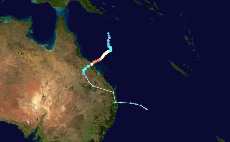
English: Track map of Severe Tropical Cyclone Debbie of the 2016-17 Australian region cyclone season. The points show the location of the storm at 6-hour intervals. The colour represents the storm's maximum sustained wind speeds as classified in the (see below), and the shape of the data points represent the nature of the storm, according to the legend below. Tropical depression (≤38 mph, ≤62 km/h)
Tropical storm (39–73 mph, 63–118 km/h)
Category 1 (74–95 mph, 119–153 km/h)
Category 2 (96–110 mph, 154–177 km/h)
Category 3 (111–129 mph, 178–208 km/h)
Category 4 (130–156 mph, 209–251 km/h)
Category 5 (≥157 mph, ≥252 km/h)
Unknown
Storm type |
||
| Date | 2017-03-23–2017-04-01 | ||
| Source | Created by Flux55 using Wikipedia:WikiProject Tropical cyclones/Tracks. The background image is from NASA. Tracking data is from the Joint Typhoon Warning Center[1]. | ||
| Author | Flux55 | ||
| Source code | Track map data table, if present below, is in HURDAT2 or ATCF format. See format details in [2] and [3], respectively.
|
Licensing[edit]
| This work has been released into the public domain by its author, Flux55. This applies worldwide. In some countries this may not be legally possible; if so: Flux55 grants anyone the right to use this work for any purpose, without any conditions, unless such conditions are required by law. |
Licensing[edit]
I, the copyright holder of this work, hereby publish it under the following license:
| This file is made available under the Creative Commons CC0 1.0 Universal Public Domain Dedication. | |
| The person who associated a work with this deed has dedicated the work to the public domain by waiving all of their rights to the work worldwide under copyright law, including all related and neighboring rights, to the extent allowed by law. You can copy, modify, distribute and perform the work, even for commercial purposes, all without asking permission.
|
File history
Click on a date/time to view the file as it appeared at that time.
| Date/Time | Thumbnail | Dimensions | User | Comment | |
|---|---|---|---|---|---|
| current | 17:34, 31 January 2024 | | 2,700 × 1,666 (1 MB) | Flux55 (talk | contribs) | {{WPTC track map | author = Flux55 | name = Severe Tropical Cyclone Debbie | article = Cyclone Debbie | season = 2016-17 Australian region cyclone season | start = 2017-03-23 | colors = new | end = 2017-04-01 | source=JTWC | catname=Cyclone Debbie (2017) | code = SI142017, DEBBIE, 36, 20170323, 0600, , DB, 14.3S, 151.7E, 20, , 0, 0, 0, 0, 0, 0, 0, 0, 0, 0, 0, 0, JTWC, 20170323, 1200, , DB, 14.7S, 151.8E, 20, , 0,... |
You cannot overwrite this file.
File usage on Commons
There are no pages that use this file.
File usage on other wikis
The following other wikis use this file:
- Usage on en.wikipedia.org
- Usage on uk.wikipedia.org