File:Delisle L'Amerique Septentrionale 1700 (1709) UTA.jpg
Jump to navigation
Jump to search

Size of this preview: 800 × 583 pixels. Other resolutions: 320 × 233 pixels | 640 × 467 pixels | 1,024 × 746 pixels | 1,280 × 933 pixels | 2,560 × 1,866 pixels | 2,922 × 2,130 pixels.
Original file (2,922 × 2,130 pixels, file size: 5.01 MB, MIME type: image/jpeg)
Captions
Captions
Add a one-line explanation of what this file represents
Summary
[edit]| Title |
Français : L'Amerique Septentrionale |
||||||||||||||||||||||||||
| Description |
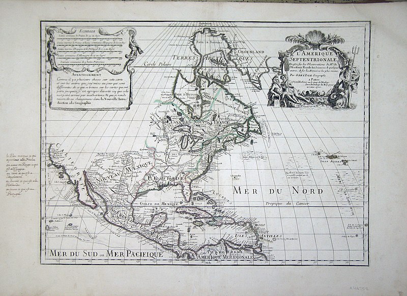
English: With cartouches by Charles Simonneau the Elder. Engraved by Berey. Guilaume Delisle was only twenty-five years old when he constructed this map, which was soon recognized as a landmark map. With this map (shown here in a later state which corrected an earlier westward bend in South America), Delisle was one of the first cartographers since 1625 to correctly show California again as a peninsula rather than as an island. By choice he left a big portion of northwestern North America blank since he had determined (correctly) that no reliable information was yet available for the area. Delisle, as a geographe de cabinet, was focused on the scientific accuracy of this map. Charles Simonneau's elegant baroque design for the decorative cartouche includes female figures symbolizing four continents. |
||||||||||||||||||||||||||
| Date | |||||||||||||||||||||||||||
| Source | UTA Libraries Cartographic Connections: map / text | ||||||||||||||||||||||||||
| Creator |
|
||||||||||||||||||||||||||
| Credit line |
English: UTA Libraries Special Collections |
||||||||||||||||||||||||||
| Geotemporal data | |||||||||||||||||||||||||||
| Map location | North America | ||||||||||||||||||||||||||
| Georeferencing | If inappropriate please set warp_status = skip to hide. | ||||||||||||||||||||||||||
| Bibliographic data | |||||||||||||||||||||||||||
| Place of publication | Paris | ||||||||||||||||||||||||||
| Printed by |
Chez l'Auteur, au Quai d’Horloge |
||||||||||||||||||||||||||
| Archival data | |||||||||||||||||||||||||||
| Collection |
|
||||||||||||||||||||||||||
| Dimensions | height: 43.5 cm (17.1 in); width: 66.5 cm (26.1 in) | ||||||||||||||||||||||||||
| Medium | colored engraving | ||||||||||||||||||||||||||

_UTA.jpg&action=edit§ion=1)
Licensing
[edit]_UTA.jpg&action=edit§ion=2)

|
This file was provided to Wikimedia Commons by the University of Texas at Arlington Libraries as part of a cooperation project. The University of Texas at Arlington Libraries is part of the University of Texas at Arlington, a public research university located in Arlington, Texas.
|
|
The author died in 1726, so this work is in the public domain in its country of origin and other countries and areas where the copyright term is the author's life plus 100 years or fewer. This work is in the public domain in the United States because it was published (or registered with the U.S. Copyright Office) before January 1, 1929. | |
| This file has been identified as being free of known restrictions under copyright law, including all related and neighboring rights. | |
File history
Click on a date/time to view the file as it appeared at that time.
| Date/Time | Thumbnail | Dimensions | User | Comment | |
|---|---|---|---|---|---|
| current | 20:12, 9 February 2022 | | 2,922 × 2,130 (5.01 MB) | Michael Barera (talk | contribs) | == {{int:filedesc}} == {{Map |title = {{fr|'''''L'Amerique Septentrionale'''''}} |description = {{en|With cartouches by Charles Simonneau the Elder. Engraved by Berey. <br /> Guilaume Delisle was only twenty-five years old when he constructed this map, which was soon recognized as a landmark map. With this map (shown here in a later state which corrected an earlier westward bend in South America), Delisle was one of the first cartographers since 1625 to correctly show Cali... |
You cannot overwrite this file.
File usage on Commons
The following page uses this file:
_UTA.jpg&oldid=879088395)