File:Demartinka.Smichov.Destroyed.1980.jpg
Jump to navigation
Jump to search
No higher resolution available.
Demartinka.Smichov.Destroyed.1980.jpg (500 × 333 pixels, file size: 87 KB, MIME type: image/jpeg)
Captions
Captions
Add a one-line explanation of what this file represents
|
This is a photo of a cultural monument of the Czech Republic,
number: 53803/1-1731. |
Summary
[edit]
| Description |
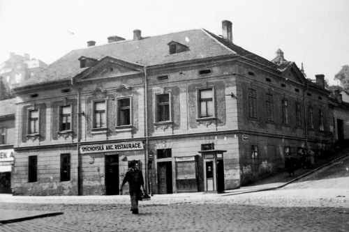
Čeština: Demartinka byla venkovská předměstská usedlost u zahrady Klamovka na adrese Praha 5-Smíchov, U Demartinky čp. 152. V době před druhou světovou válkou byla v přízemí budovy provozována "Smíchovská akciová restaurace". Usedlost byla zbořena v roce 1980.
English: Demartinka was the rural homestead near a garden Klamovka at Prague 5, Smíchov Street "U Demartinky" house number 152. In the time before World War II functioned on the ground floor "Joint stock Smíchov restaurant." The building was demolished in 1980. |
|||
| Date | ||||
| Source | http://smichov.blog.cz/0712/demartinka | |||
| Author | Unknown author | |||
| Permission (Reusing this file) |
|
| Camera location | | View this and other nearby images on: OpenStreetMap |
|---|
File history
Click on a date/time to view the file as it appeared at that time.
| Date/Time | Thumbnail | Dimensions | User | Comment | |
|---|---|---|---|---|---|
| current | 21:40, 17 January 2016 | | 500 × 333 (87 KB) | Mojmir Churavy (talk | contribs) | User created page with UploadWizard |
You cannot overwrite this file.
File usage on Commons
The following page uses this file:
File usage on other wikis
The following other wikis use this file:
- Usage on cs.wikipedia.org
- Usage on www.wikidata.org