File:DepartementsFranceDensitePopulation.svg
跳转到导航
跳转到搜索

此SVG文件的PNG预览的大小:507 × 553像素。 其他分辨率:220 × 240像素 | 440 × 480像素 | 704 × 768像素 | 939 × 1,024像素 | 1,878 × 2,048像素。
原始文件 (SVG文件,尺寸为507 × 553像素,文件大小:157 KB)
说明
说明
添加一行文字以描述该文件所表现的内容
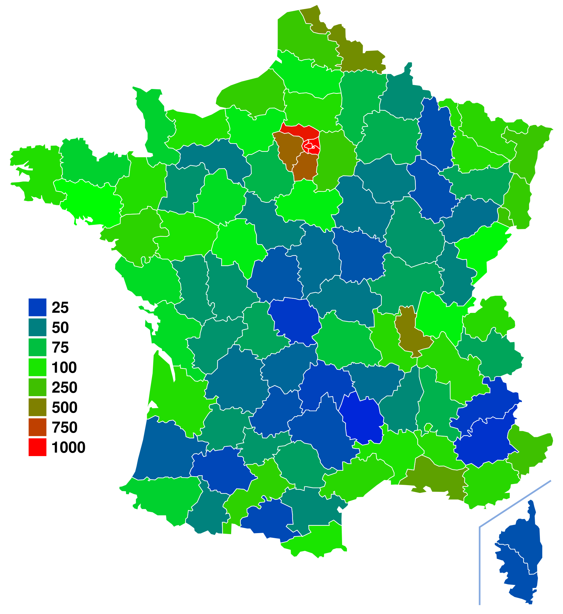
| 描述 | Départements de France. For more information on how to edit this file, see FRA-Map Documentation |
| 日期 | (UTC) |
| 来源 | |
| 作者 |
|
| 这是一张修改过的图片,这意味着它已在原版本的基础上通过软件进行了编辑,改动内容:Colored departement by population density using fr:Départements_français_classés_par_densité_de_population data。其原始版本为:Départements de France-simple.svg。
|
| 我,本作品著作权人,释出本作品至公有领域。这适用于全世界。 在一些国家这可能不合法;如果是这样的话,那么: 我无条件地授予任何人以任何目的使用本作品的权利,除非这些条件是法律规定所必需的。 |
原始上传日志
[编辑]
This image is a derivative work of the following images:
- Image:Départements_de_France-simple.svg licensed with PD-self
- 2007-09-09T11:49:17Z Marmelad 507x553 (148302 Bytes) added a box zoomed in around Paris to show the small departements near the city, as in [[:Image:Carte France Département 95.png]] (currently hidden). For documentation on how to use this image, see [[:User:Marmelad/FRA-Map
- 2007-09-08T17:06:31Z Marmelad 507x553 (147117 Bytes) Cleaned up the svg code for use with auto-generating software.
- 2007-04-24T09:27:36Z Emmanuel.boutet 507x553 (184098 Bytes) {{Information |Description=Version simplifiée de [[:Image:Départements et régions de France.svg]] |Source=[[:Image:Départements et régions de France.svg]] by [[User:bayo|bayo]] |Date=2007-04-24 |Author=[[User:Emmanuel.bo
Uploaded with derivativeFX
文件历史
点击某个日期/时间查看对应时刻的文件。
| 日期/时间 | 缩略图 | 大小 | 用户 | 备注 | |
|---|---|---|---|---|---|
| 当前 | 2008年6月20日 (五) 15:51 | | 507 × 553(157 KB) | Ske(留言 | 贡献) | {{Information |Description=Départements de France. For more information on how to edit this file, see FRA-Map Documentation |Source=*Image:Départements_de_France-simple.svg |Date=2008-06-20 15:50 (UTC) |A |
您不可以覆盖此文件。
文件用途
以下页面使用本文件:
全域文件用途
以下其他wiki使用此文件:
- ar.wikipedia.org上的用途
- bg.wikipedia.org上的用途
- de.wikipedia.org上的用途
- en.wikipedia.org上的用途
- es.wikipedia.org上的用途
- fr.wikipedia.org上的用途
- nl.wikipedia.org上的用途
- ru.wikipedia.org上的用途
- simple.wikipedia.org上的用途
- sq.wikipedia.org上的用途
- uk.wikipedia.org上的用途
- zh.wikipedia.org上的用途