File:Departments of French Empire North 1811-fr.svg
跳至導覽
跳至搜尋

此 SVG 檔案的 PNG 預覽的大小:406 × 599 像素。 其他解析度:162 × 240 像素 | 325 × 480 像素 | 520 × 768 像素 | 694 × 1,024 像素 | 1,387 × 2,048 像素 | 525 × 775 像素。
原始檔案 (SVG 檔案,表面大小:525 × 775 像素,檔案大小:144 KB)
說明
說明
添加單行說明來描述出檔案所代表的內容
摘要[編輯]
| 描述 |
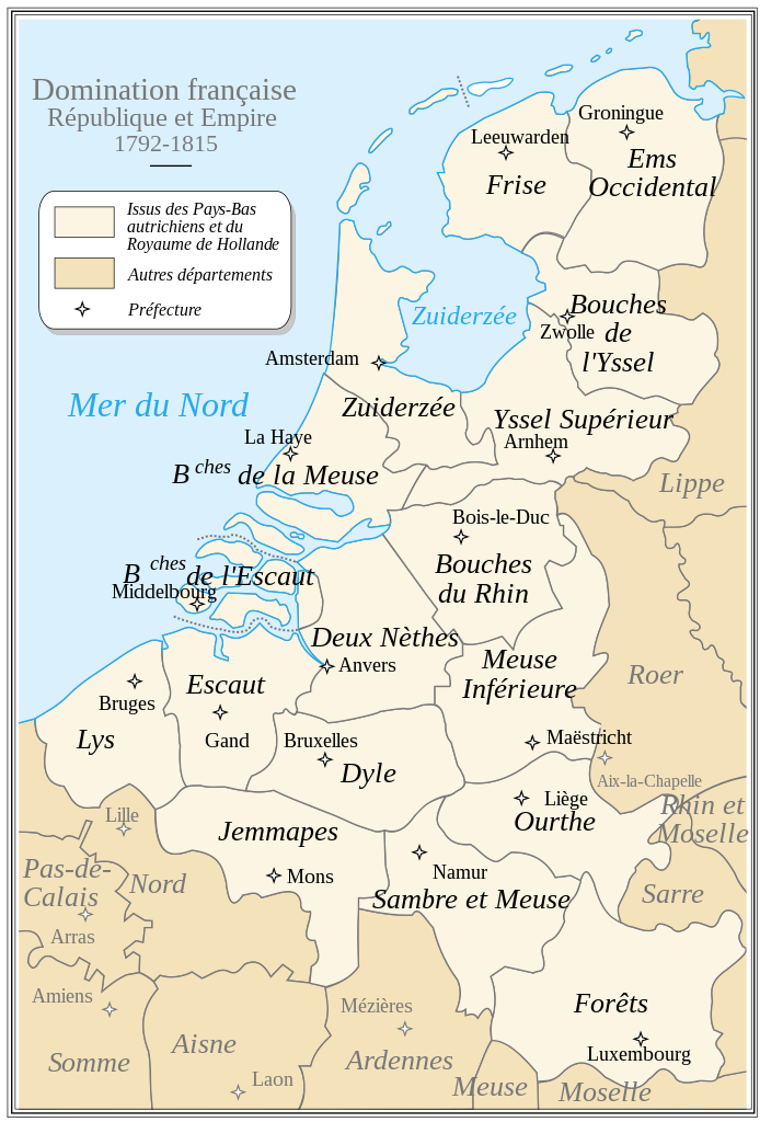
English: French Departements of the North of the first Empire (1811). Be careful: this map is an historical map. The precision is not sufficient for a modern use.
Français : Les départements du Nord du 1er Empire français (1811). Attention : cette carte est une carte historique. La qualité de sa précision ne permet pas une utilisation dans un contexte moderne. |
| 日期 | |
| 來源 | Tiré d'une carte établie en 1811 par Messieurs Drioux et Leroy. |
| 作者 | Ewan ar Born |
本vector image使用Inkscape創作 .

|
This SVG file contains embedded text that can be translated into your language, using any capable SVG editor, text editor or the SVG Translate tool. For more information see: About translating SVG files. |
授權條款[編輯]
| 我,此作品的版權所有人,釋出此作品至公共領域。此授權條款在全世界均適用。 這可能在某些國家不合法,如果是的話: 我授予任何人有權利使用此作品於任何用途,除受法律約束外,不受任何限制。 |
檔案歷史
點選日期/時間以檢視該時間的檔案版本。
| 日期/時間 | 縮圖 | 尺寸 | 使用者 | 備註 | |
|---|---|---|---|---|---|
| 目前 | 2008年9月30日 (二) 17:09 | | 525 × 775(144 KB) | Ewan ar Born(留言 | 貢獻) | Remplacé Hainaut/Tournai par Jemmapes/Mons. |
| 2008年9月29日 (一) 13:15 |  | 525 × 775(144 KB) | Ewan ar Born(留言 | 貢獻) | == Description == {{Information |Description={{fr|1=Les départements du Nord du 1er Empire français (1811). Attention: Cette carte est une carte historique. La qualité de sa précision ne permet pas une utilisation dans un contexte moderne.}} {{en|1=Fr |
無法覆蓋此檔案。
檔案用途
沒有使用此檔案的頁面。
全域檔案使用狀況
以下其他 wiki 使用了這個檔案:
- br.wikipedia.org 的使用狀況
- ca.wikipedia.org 的使用狀況
- el.wikipedia.org 的使用狀況
- en.wikipedia.org 的使用狀況
- eo.wikipedia.org 的使用狀況
- es.wikipedia.org 的使用狀況
- fr.wikipedia.org 的使用狀況
- Province de Luxembourg
- Meuse-Inférieure
- Histoire du Luxembourg
- Forêts (département)
- Bouches-de-l'Escaut
- Ems-Occidental
- Lys (département)
- Deux-Nèthes
- Yssel-Supérieur
- Sambre-et-Meuse
- Escaut (département)
- Histoire des départements français
- Dyle (département)
- Frise (département)
- Duché de Luxembourg
- Jemmapes (département)
- Province de Limbourg (1815-1839)
- Départements des Pays-Bas
- Charles Van Hulthem
- Wikipédia:Atelier graphique/Cartes/Archives/septembre 2008
- Flandre (terminologie)
- Siège d'Anvers (1814)
- Histoire militaire du Luxembourg
- Frontières du Luxembourg
- fr.wiktionary.org 的使用狀況
- lb.wikipedia.org 的使用狀況
檢視此檔案的更多全域使用狀況。