File:Deschutes Wild and Scenic River -- Grey Eagle (26215891364).jpg

Original file (3,264 × 2,448 pixels, file size: 2.42 MB, MIME type: image/jpeg)
Captions
Captions
Summary
[edit].jpg&action=edit§ion=1)
| Description |
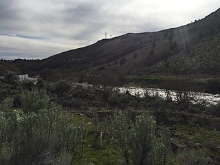
Do you enjoy rafting trips, fly-fishing for native steelhead and-or huge central Oregon skies? Well, if so, the Deschutes Wild and Scenic River may be your nature wonderland. From the Oregon-Washington border past the whitewater rafting community of Maupin, the BLM manages dozens of camping sites, boat ramps and picnic areas along the Deschutes. Also along the river is the 34-mile-long Deschutes River Backcountry Byway. The 9-mile-long paved section ends at Sherars Falls, where Native Americans still fish for salmon using traditional platforms and nets. After that the road is mostly gravel for another 25 miles to Macks Canyon. These photos, captured in March of 2016, are from the Macks Canyon site, which boasts riverside campsites, amazing canyon views and the occasional freight train encounter. For more information on how to visit the Deschutes River, call our district office in Prineville at 541-416-6700 or visit here: <a href="http://www.blm.gov/visit" rel="nofollow">www.blm.gov/visit</a> Photos and video clips by Greg Shine, BLM |
| Date | |
| Source | Deschutes Wild and Scenic River -- Grey Eagle |
| Author | Bureau of Land Management Oregon and Washington from Portland, America |
| Camera location | | View this and other nearby images on: OpenStreetMap |
|---|
.jpg¶ms=045.193194_N_-121.082267_E_globe:Earth_type:camera_alt:250.39695_source:exif_heading:206.21&language=en)
Licensing
[edit].jpg&action=edit§ion=2)
- You are free:
- to share – to copy, distribute and transmit the work
- to remix – to adapt the work
- Under the following conditions:
- attribution – You must give appropriate credit, provide a link to the license, and indicate if changes were made. You may do so in any reasonable manner, but not in any way that suggests the licensor endorses you or your use.
| This image was originally posted to Flickr by BLMOregon at https://flickr.com/photos/50169152@N06/26215891364 (archive). It was reviewed on 12 May 2018 by FlickreviewR 2 and was confirmed to be licensed under the terms of the cc-by-2.0. |
| This image is a work of a Bureau of Land Management* employee, taken or made as part of that person's official duties. As a work of the U.S. federal government, the image is in the public domain in the United States. *or predecessor organization |
File history
Click on a date/time to view the file as it appeared at that time.
| Date/Time | Thumbnail | Dimensions | User | Comment | |
|---|---|---|---|---|---|
| current | 16:58, 12 May 2018 | | 3,264 × 2,448 (2.42 MB) | OceanAtoll (talk | contribs) | Transferred from Flickr via #flickr2commons |
You cannot overwrite this file.
File usage on Commons
There are no pages that use this file.
.jpg&oldid=897970359)