File:Description De Mexico et des Lagunes De Ses Environs Gemelli Careri.jpg
Jump to navigation
Jump to search

Size of this preview: 759 × 599 pixels. Other resolutions: 304 × 240 pixels | 608 × 480 pixels | 973 × 768 pixels | 1,280 × 1,011 pixels | 1,646 × 1,300 pixels.
Original file (1,646 × 1,300 pixels, file size: 1.62 MB, MIME type: image/jpeg)
Captions
Captions
Add a one-line explanation of what this file represents
Summary[edit]
| Description |
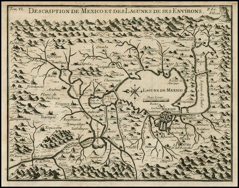
English: "Rare map of the area around Mexio City, centered on the large Lagune de Mexico and extends to include the surrounding mountains, rivers, towns and villages, reportedly derived from a copy an original native map while Careri was in Mexico. The map is drawn on a partial bird's-eye format, with an imaginary horizon that includes an erupting volcano at upper right. Many villages are located including Pachuca, Tacoma, Atlapilco, Tolodyuca, Tetlapanaloya, and Apazco. Careri's account states that the map is a copy of a map drawn by Charles Siguenza of an original drawn by native Americans. The Mexicans were told to search for a place that would be shown to them by the presence of an eagle standing on a cactus growing out of a rock. This place is Tenochtitlán or the present-day Mexico City. The present map is from an edition of Careri's account published in Paris. The work also appears in Churchill's collection of voyages and travels, published in London, 1704." |
| Date | |
| Source | Voyage du Tour du Monde (1719, Paris: French Translation of "Giro Del Mondo"). |
| Author | Gemelli Careri |
Licensing[edit]
I, the copyright holder of this work, hereby publish it under the following license:
| This file is made available under the Creative Commons CC0 1.0 Universal Public Domain Dedication. | |
| The person who associated a work with this deed has dedicated the work to the public domain by waiving all of their rights to the work worldwide under copyright law, including all related and neighboring rights, to the extent allowed by law. You can copy, modify, distribute and perform the work, even for commercial purposes, all without asking permission.
|
File history
Click on a date/time to view the file as it appeared at that time.
| Date/Time | Thumbnail | Dimensions | User | Comment | |
|---|---|---|---|---|---|
| current | 23:18, 4 May 2011 | | 1,646 × 1,300 (1.62 MB) | Dottos (talk | contribs) | {{Information |Description ={{en|1="Rare map of the area around Mexio City, centered on the large Lagune de Mexico and extends to include the surrounding mountains, rivers, towns and villages, reportedly derived from a copy an original native map while |
You cannot overwrite this file.
File usage on Commons
There are no pages that use this file.
File usage on other wikis
The following other wikis use this file:
- Usage on en.wikipedia.org
- Usage on fr.wikipedia.org
- Usage on kn.wikipedia.org
- Usage on lij.wikipedia.org