File:Desenberg Westansicht Panorama 2014.jpg

原始檔案 (11,576 × 2,040 像素,檔案大小:9.23 MB,MIME 類型:image/jpeg)
說明
說明
摘要
[編輯]| 描述 |
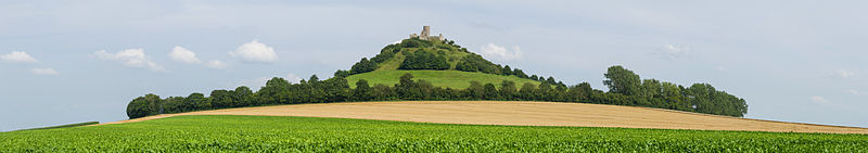
Deutsch: Panorama des Desenberg, Westansicht. Der Desenberg bei Daseburg, ein Inselberg und früherer Basaltvulkan, im nordrhein-westfälischen Kreis Höxter, ist die markanteste Erhebung der Warburger Börde. Auf der Spitze befindet sich die Burgruine Desenberg. Auf der Gipfelregion liegt ein eigenes Fauna-Flora-Habitat.
English: Panoramic view of Desenberg, western view. The hill Desenberg, a former volcano, near the village Daseburg is located in the area of Höxter in North Rhine-Westphalia. It is the most remarkable landmark of Warburger Börde flatlands. The area around the top has a very special flora and fauna due to its island position.
Português: Vista panorâmica do Desenberg, um vulcão extinto próximo a aldeia de Daseburg no distrito de Höxter, Renânia do Norte-Vestfália, Alemanha.
Български: Панорамен изглед от запад към хълма и някогашен вулкан Десенберг, Северен Райн-Вестфалия.
Bosanski: Panorama brda Desenberg, pogled sa zapada. Desenberg kod Daseburga je usamljeno brdo i ugašeni bazaltni vulkan u okrugu Höxter, Sjeverna Rajna-Vestfalija.
Español: Vista panorámica del antiguo volcán Desenberg cerca de la aldea Daseburg, Distrito de Höxter, Renania del Norte-Westfalia, Alemania.
Magyar: Desenberg, a Daseburg melletti vulkanikus tanúhegy panorámája nyugat felé nézve (Németország, Észak-Rajna-Vesztfália, Höxter kerület)
Italiano: Vista panoramica di Desenberg, un vulcano estinto vicino al villaggio di Daseburg nei pressi di Warburg in Germania.
한국어: 데젠베르크(Desenberg)의 서쪽 풍경. 예전에 화산이었던, 데젠부르크 마을 부근의 '데젠베르크' 언덕은 노르트라인베스트팔렌 주 획스터 영내에 위치한다. 이 언덕은 바르부르크 평원에서 가장 주목할 만한 랜드마크이다.
Nederlands: Panoramisch uitzicht op de Desenberg in de Duitse kreis Höxter. |
| 日期 | |
| 來源 | 自己的作品 |
| 作者 | Tuxyso |
| 姓名標示 (由许可协议要求) | Tuxyso / Wikimedia Commons / |
| 拍攝地點 | | 位於此地的本圖片與其他圖片: OpenStreetMap |
|---|
This image was selected as picture of the day on Wikimedia Commons for 23 May 2015. It was captioned as follows: English: Panoramic view of Desenberg, western view. The hill Desenberg, a former volcano, near the village Daseburg is located in the area of Höxter in North Rhine-Westphalia. It is the most remarkable landmark of Warburger Börde flatlands. Other languages:
Bosanski: Panorama brda Desenberg, pogled sa zapada. Desenberg kod Daseburga je usamljeno brdo i ugašeni bazaltni vulkan u okrugu Höxter, Sjeverna Rajna-Vestfalija. Deutsch: Panorama des Desenberg, Westansicht. Der Desenberg bei Daseburg, ein Inselberg und früherer Basaltvulkan, im nordrhein-westfälischen Kreis Höxter, ist die markanteste Erhebung der Warburger Börde. English: Panoramic view of Desenberg, western view. The hill Desenberg, a former volcano, near the village Daseburg is located in the area of Höxter in North Rhine-Westphalia. It is the most remarkable landmark of Warburger Börde flatlands. Español: Vista panorámica del antiguo volcán Desenberg cerca de la aldea Daseburg, Distrito de Höxter, Renania del Norte-Westfalia, Alemania. Italiano: Vista panoramica di Desenberg, un vulcano estinto vicino al villaggio di Daseburg nei pressi di Warburg in Germania. Magyar: Desenberg, a Daseburg melletti vulkanikus tanúhegy panorámája nyugat felé nézve (Németország, Észak-Rajna-Vesztfália, Höxter kerület) Nederlands: Panoramisch uitzicht op de Desenberg in de Duitse kreis Höxter. Português: Vista panorâmica do Desenberg, um vulcão extinto próximo a aldeia de Daseburg no distrito de Höxter, Renânia do Norte-Vestfália, Alemanha. Български: Панорамен изглед от запад към хълма и някогашен вулкан Десенберг, Северен Райн-Вестфалия. 한국어: 데젠베르크(Desenberg)의 서쪽 풍경. 예전에 화산이었던, 데젠부르크 마을 부근의 '데젠베르크' 언덕은 노르트라인베스트팔렌 주 획스터 영내에 위치한다. 이 언덕은 바르부르크 평원에서 가장 주목할 만한 랜드마크이다. |
|
|
授權條款
[編輯]- 您可以自由:
- 分享 – 複製、發佈和傳播本作品
- 重新修改 – 創作演繹作品
- 惟需遵照下列條件:
- 姓名標示 – 您必須指名出正確的製作者,和提供授權條款的連結,以及表示是否有對內容上做出變更。您可以用任何合理的方式來行動,但不得以任何方式表明授權條款是對您許可或是由您所使用。
- 相同方式分享 – 如果您利用本素材進行再混合、轉換或創作,您必須基於如同原先的相同或兼容的條款,來分布您的貢獻成品。
|
Dieses Foto ist vom Wikimedia Commons Nutzer Tuxyso. Achtung: Dieses Bild ist nicht gemeinfrei. Es ist zwar frei benutzbar aber gesetzlich geschützt. |
This photo was created by Wikimedia Commons user Tuxyso. Note: this image is not in the Public Domain. It is free to use but protected by law. |
||
|
|
Bitte benutzen sie nach Möglichkeit in der Bildbeschreibung: Tuxyso / Wikimedia Commons / CC-BY-SA-3.0 in unmittelbarer Nähe beim Bild oder an einer Stelle in ihrer Publikation, wo dies üblich ist. Dabei muß der Zusammenhang zwischen Bild und Urhebernennung gewahrt bleiben. |
I prefer the following credit: Tuxyso / Wikimedia Commons / CC-BY-SA-3.0 near to the photo or at a location that is common in your publication but preserving the association between image and credit. |
 |
|
Bitte lesen sie den Lizenztext gründlich, bevor sie das Bild nutzen! Wenn sie Fragen zu den Lizenzvereinbarungen haben oder mich auf eine interessante Nachnutzung hinweisen möchten, kontaktieren sie mich bitte per Mail: tuxyso@gmail.com. |
Please review the license requirements carefully before using this image. If you would like to clarify the license terms or inform me about a reuse of the image (which is always interesting for me), please contact me by email: tuxyso@gmail.com. |
||

檔案歷史
點選日期/時間以檢視該時間的檔案版本。
| 日期/時間 | 縮圖 | 尺寸 | 用戶 | 備註 | |
|---|---|---|---|---|---|
| 目前 | 2014年8月9日 (六) 14:33 | 11,576 × 2,040(9.23 MB) | Tuxyso(對話 | 貢獻) | slightly modified WB | |
| 2014年8月7日 (四) 21:55 | 11,576 × 2,040(9.31 MB) | Tuxyso(對話 | 貢獻) | work on the sky | ||
| 2014年8月6日 (三) 21:06 | 11,576 × 2,040(9.08 MB) | Tuxyso(對話 | 貢獻) | VicuñaUploader 1.20 |
無法覆蓋此檔案。
檔案用途
下列34個頁面有用到此檔案:
- User:Beria/POTY per date
- User:Miya/POTY/2014
- User:Tuxyso/Galerie
- User:Tuxyso/Galerie QI
- User:Überraschungsbilder/Archiv/2019
- User talk:Tuxyso/Archive 6
- Commons:Featured picture candidates/File:Desenberg Westansicht Panorama 2014.jpg
- Commons:Featured picture candidates/Log/August 2014
- Commons:Featured pictures/Places/Agriculture
- Commons:Featured pictures/Places/Panoramas
- Commons:Featured pictures/chronological/2014-B
- Commons:Picture of the Year/2014/Candidates
- Commons:Picture of the Year/2014/R1/Gallery/2014-B
- Commons:Picture of the Year/2014/R1/Gallery/ALL
- Commons:Picture of the Year/2014/R1/Gallery/M08
- Commons:Picture of the Year/2014/R1/Gallery/Panoramic views
- Commons:Picture of the Year/2014/R1/Results/Candidates
- Commons:Picture of the Year/2014/R1/Results/Candidates/Panoramic views
- Commons:Picture of the Year/2014/R1/Results/Panoramic views
- Commons:Picture of the Year/2014/R1/v/Desenberg Westansicht Panorama 2014.jpg
- Commons:Quality images/Subject/Places/Natural structures/Panorama/Archive 2008 to 2015
- Commons:Quality images candidates/Archives August 10 2014
- Template:Potd/2015-05
- Template:Potd/2015-05-23
- Template:Potd/2015-05-23 (bg)
- Template:Potd/2015-05-23 (bs)
- Template:Potd/2015-05-23 (de)
- Template:Potd/2015-05-23 (en)
- Template:Potd/2015-05-23 (es)
- Template:Potd/2015-05-23 (hu)
- Template:Potd/2015-05-23 (it)
- Template:Potd/2015-05-23 (ko)
- Template:Potd/2015-05-23 (nl)
- Template:Potd/2015-05-23 (pt)
全域檔案使用狀況
以下其他 wiki 使用了這個檔案:
- be-tarask.wikipedia.org 的使用狀況
- bn.wikipedia.org 的使用狀況
- crh.wikipedia.org 的使用狀況
- cv.wikipedia.org 的使用狀況
- de.wikipedia.org 的使用狀況
- hu.wikipedia.org 的使用狀況
- ka.wikipedia.org 的使用狀況
- ko.wikipedia.org 的使用狀況
- krc.wikipedia.org 的使用狀況
- lbe.wikipedia.org 的使用狀況
- mg.wikipedia.org 的使用狀況
- os.wikipedia.org 的使用狀況
- pt.wikipedia.org 的使用狀況
- ru.wikipedia.org 的使用狀況
- ru.wikinews.org 的使用狀況
- sah.wikipedia.org 的使用狀況
- tt.wikipedia.org 的使用狀況
- uk.wikipedia.org 的使用狀況
- vi.wikipedia.org 的使用狀況
- zh.wikipedia.org 的使用狀況