File:Desierto de Lut, Irán, 2016-09-22, DD 44-49 HDR PAN.jpg

原始文件 (9,175 × 2,105像素,文件大小:9.35 MB,MIME类型:image/jpeg)
说明
说明
摘要[编辑]
| 描述 |
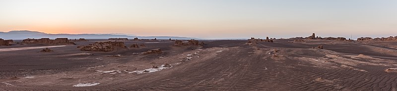
Español: Vista panorámica del desierto de Lut (Dasht-e Loot), que traudcido significa "Desierto del vacío", situados en las provincias de Kermán y Sistán y Baluchistán, Irán. Este parte del mundo tiene particularidad de haber registrado la mayor temperatura medida en la superficie de la tierra (70 °C) y es, desde julio de 2016, patrimonio de la Humanidad según la UNESCO.
English: Panoramic view during sunset of Dasht-e Loot, in English "Emptiness desert", located in the provinces of Kerman and Sistan-Baluchistan, Iran. This place is pretty special for being the spot on the Earth where the highest temperature was ever measured (70 °C or 159 °F) and since July 2016 a UNESCO World Heritage Site.
Polski: Panorama pustyni Lut położonej w ostanach Kerman oraz Sistan i Beludżystan w Iranie. Jest to szczególne miejsce, ponieważ zanotowano tutaj najwyższą temperaturę gruntu na Ziemi, 70,7 °C, a od lipca 2016 pustynia znajduje się na liście światowego dziedzictwa UNESCO.
Čeština: Panoramatický pohled na západ slunce nad solnou pouští Lút v provincii Chorásán na východě Íránu. Na tomto místě byla v červenci roku 2016 naměřena nejvyšší povrchová teplota na Zemi - + 70 °C a oblast je součástí Světového dědictví UNESCO.
Deutsch: Panoramablick während des Sonnenuntergangs in der Dasht-e Lut (persisch دشت لوت, wörtlich „Ebene der Leere“), in den Provinzen Kerman und Sistan-Belutschistan im Iran. An diesem Ort wurde mit 70 °C die höchste jemals auf der Erde gemessene Temperatur dokumentiert und er ist seit Juli 2016 eine Welterbestätte der UNESCO.
Македонски: Залез над пустината Дешт-е Лут во Иран, прогласена за светско наследство на УНЕСКО.
Nederlands: In de Dasht-e Lut in het zuidoosten van Iran zijn bodemtemperaturen van meer dan 70 °C gemeten
Português: Vista panorâmica do deserto de Lut (Dast-e Lut), que traduzido significa "Deserto do vazio", situado nas províncias de Kerman e Sistão-Baluchistão, Irã. |
||||||||||||||||||||
| 日期 | |||||||||||||||||||||
| 来源 | 自己的作品 | ||||||||||||||||||||
| 作者 |
|
||||||||||||||||||||

| 相机位置 | | 在以下服务上查看本图像和附近其他图像: OpenStreetMap |
|---|
评价[编辑]
|
This image was selected as picture of the day on Wikimedia Commons for 27 January 2019. It was captioned as follows: English: Panoramic view during sunset of Dasht-e Lut, in English "Emptiness desert", located in the provinces of Kerman and Sistan-Baluchistan, Iran. This place is pretty special for being the spot on the Earth where the highest temperature ever was measured (70 °C or 159 °F) and since July 2016 a UNESCO World Heritage Site. Other languages:
Čeština: Panoramatický pohled na západ slunce nad solnou pouští Lút v provincii Chorásán na východě Íránu. Na tomto místě byla v červenci roku 2016 naměřena nejvyšší povrchová teplota na Zemi - + 70 °C a oblast je součástí Světového dědictví UNESCO. Deutsch: Panoramablick während des Sonnenuntergangs in der Dasht-e Lut (persisch دشت لوت, wörtlich „Ebene der Leere“), in den Provinzen Kerman und Sistan-Belutschistan im Iran. An diesem Ort wurde mit 70 °C die höchste jemals auf der Erde gemessene Temperatur dokumentiert und er ist seit Juli 2016 eine Welterbestätte der UNESCO. English: Panoramic view during sunset of Dasht-e Lut, in English "Emptiness desert", located in the provinces of Kerman and Sistan-Baluchistan, Iran. This place is pretty special for being the spot on the Earth where the highest temperature ever was measured (70 °C or 159 °F) and since July 2016 a UNESCO World Heritage Site. Español: Vista panorámica del desierto de Lut (Dasht-e Loot), que traudcido significa "Desierto del vacío", situados en las provincias de Kermán y Sistán y Baluchistán, Irán. Este parte del mundo tiene particularidad de haber registrado la mayor temperatura medida en la superficie de la tierra (70 °C) y es, desde julio de 2016, patrimonio de la Humanidad según la UNESCO. Nederlands: In de Dasht-e Lut in het zuidoosten van Iran zijn bodemtemperaturen van meer dan 70 °C gemeten Polski: Panorama pustyni Lut położonej w ostanach Kerman oraz Sistan i Beludżystan w Iranie. Jest to szczególne miejsce, ponieważ zanotowano tutaj najwyższą temperaturę gruntu na Ziemi, 70,7 °C, a od lipca 2016 pustynia znajduje się na liście światowego dziedzictwa UNESCO. Português: Vista panorâmica do deserto de Lut (Dast-e Lut), que traduzido significa "Deserto do vazio", situado nas províncias de Kerman e Sistão-Baluchistão, Irã. Македонски: Залез над пустината Дешт-е Лут во Иран, прогласена за светско наследство на УНЕСКО. |
许可协议[编辑]
Another one of my pictures: Want to see more works of mine? click here |
Under this condition:
Please, use this work legally fulfilling the terms of the license! Please, let me know if you use this work outside Wikimedia Commons sending me an email on Furthermore, if you:
please, do not hesitate to contact me. |

|
Please do not overwrite the author's version with a modified image without discussing with the author. The author would like to make corrections only from the uncompressed RAW file. This ensures that changes are preserved and are based on the best possible source to achieve a high quality. If you think that changes are required, please, get in touch with the author. Otherwise, you can upload a new image with a different name without overwriting this one. Use {{Derived from}} or {{Extracted from}} for this purpose. |
- 您可以自由地:
- 共享 – 复制、发行并传播本作品
- 修改 – 改编作品
- 惟须遵守下列条件:
- 署名 – 您必须对作品进行署名,提供授权条款的链接,并说明是否对原始内容进行了更改。您可以用任何合理的方式来署名,但不得以任何方式表明许可人认可您或您的使用。
- 相同方式共享 – 如果您再混合、转换或者基于本作品进行创作,您必须以与原先许可协议相同或相兼容的许可协议分发您贡献的作品。
文件历史
点击某个日期/时间查看对应时刻的文件。
| 日期/时间 | 缩略图 | 大小 | 用户 | 备注 | |
|---|---|---|---|---|---|
| 当前 | 2017年6月25日 (日) 14:22 | 9,175 × 2,105(9.35 MB) | Poco a poco(留言 | 贡献) | Curves, crop | |
| 2016年10月8日 (六) 17:08 | 9,158 × 3,071(13.56 MB) | Poco a poco(留言 | 贡献) | User created page with UploadWizard |
您不可以覆盖此文件。
文件用途
以下28个页面使用本文件:
- User:Poco a poco/Nature
- User:Poco a poco/Panoramas
- User talk:Poco a poco/2017-07
- User talk:Poco a poco/2018-04
- Commons:Featured picture candidates/File:Desierto de Lut, Irán, 2016-09-22, DD 44-49 HDR PAN.jpg
- Commons:Featured picture candidates/Log/July 2017
- Commons:Featured pictures/Places/Natural
- Commons:Featured pictures/chronological/2017-B
- Commons:Picture of the Year/2017/Candidates
- Commons:Picture of the Year/2017/R1/Gallery/2017-B
- Commons:Picture of the Year/2017/R1/Gallery/ALL
- Commons:Picture of the Year/2017/R1/Gallery/M07
- Commons:Picture of the Year/2017/R1/Gallery/Panoramic views
- Commons:Picture of the Year/2017/R1/v/Desierto de Lut, Irán, 2016-09-22, DD 44-49 HDR PAN.jpg
- Commons:Quality images/Subject/Places/Natural structures/Panorama/Archive 2018-2019
- Commons:Quality images candidates/Archives April 07 2018
- Template:Potd/2019-01
- Template:Potd/2019-01-27
- Template:Potd/2019-01-27 (cs)
- Template:Potd/2019-01-27 (de)
- Template:Potd/2019-01-27 (en)
- Template:Potd/2019-01-27 (es)
- Template:Potd/2019-01-27 (hu)
- Template:Potd/2019-01-27 (mk)
- Template:Potd/2019-01-27 (nl)
- Template:Potd/2019-01-27 (pl)
- Template:Potd/2019-01-27 (pt)
- Template:Potd/2019-01-27 (pt-br)
全域文件用途
以下其他wiki使用此文件:
- be-tarask.wikipedia.org上的用途
- crh.wikipedia.org上的用途
- cv.wikipedia.org上的用途
- fa.wikipedia.org上的用途
- fr.wikipedia.org上的用途
- hu.wikipedia.org上的用途
- hy.wikipedia.org上的用途
- it.wikipedia.org上的用途
- ka.wikipedia.org上的用途
- ko.wikipedia.org上的用途
- lbe.wikipedia.org上的用途
- lez.wikipedia.org上的用途
- mk.wikipedia.org上的用途
- os.wikipedia.org上的用途
- pt.wikipedia.org上的用途
- ru.wikipedia.org上的用途
- ru.wikinews.org上的用途
- sah.wikipedia.org上的用途
- sq.wikipedia.org上的用途
- tt.wikipedia.org上的用途
- vep.wikipedia.org上的用途
- zh.wikipedia.org上的用途