File:Desierto de Lut, Irán, 2016-09-22, DD 71-86 HDR PAN.jpg

原始文件 (13,835 × 4,230像素,文件大小:22.73 MB,MIME类型:image/jpeg)
说明
说明
摘要
[编辑]| 描述 |
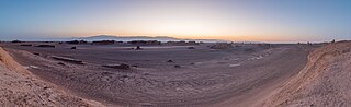
Español: Vista panorámica HDR de aprox. 180 grados del desierto de Lut (Dasht-e Loot), que traudcido significa "Desierto del vacío", situados en las provincias de Kermán y Sistán y Baluchistán, Irán. Este parte del mundo tiene particularidad de haber registrado la mayor temperatura medida en la superficie de la tierra (70 °C) y es, desde julio de 2016, patrimonio de la Humanidad según la UNESCO.
English: HDR panoramic view of approx. 180 degrees during sunset of Dasht-e Loot, in English "Emptiness desert", located in the provinces of Kerman and Sistan-Baluchistan, Iran. This place is pretty special for being the spot on the Earth where the highest temperature was ever measured (70 °C or 159 °F) and since July 2016 a UNESCO World Heritage Site.
Polski: Panorama pustyni Lut położonej w ostanach Kerman oraz Sistan i Beludżystan w Iranie. Jest to szczególne miejsce, ponieważ zanotowano tutaj najwyższą temperaturę gruntu na Ziemi, 70,7 °C, a od lipca 2016 pustynia znajduje się na liście światowego dziedzictwa UNESCO.
Українська: Панорамний вид прибл. 180° під час заходу сонця пустелі «Дашт-е Лут», («Пустеля порожнечі»), яка розташована в провінціях Керман та Сістан-Белуджистан, Іран. Це найжаркіше місце на Землі, де коли-небудь вимірювали найвищу температуру 70 °C. Всесвітня спадщина ЮНЕСКО з липня 2016 року.
Bahasa Indonesia: Pemandangan panoramik HDR Dasht-e-Loot ("Gurun Kekosongan"), provinsi Kerman dan Sistan-Baluchistan, Iran, sebesar rata-rata 180 derajat saat matahari terbenam. Situs Warisan Dunia UNESCO yang ditetapkan sejak bulan Juli 2016 ini adalah tempat dimana suhu tertinggi di Bumi pernah tercatat (70 °C or 159 °F). |
||||||||||||||||||||
| 日期 | |||||||||||||||||||||
| 来源 | 自己的作品 | ||||||||||||||||||||
| 作者 |
|
||||||||||||||||||||

| 相机位置 | | 在以下服务上查看本图像和附近其他图像: OpenStreetMap |
|---|
|
This image was selected as picture of the day on Wikimedia Commons for 16 August 2022. It was captioned as follows: English: HDR panoramic view of approx. 180 degrees during sunset of Dasht-e Loot, in English "Emptiness desert", located in the provinces of Kerman and Sistan-Baluchistan, Iran. This place is pretty special for being the spot on the Earth where the highest temperature was ever measured (70 °C or 159 °F) and since July 2016 a UNESCO World Heritage Site. Other languages:
Čeština: Panoramatický snímek zachycující úhel 180 stupňů během západu slunce v oblasti solné pouště Lút (Dasht-e Loot), česky "Nejprázdnější poušt" v íránských provinciích Kermán a Sístán a Balúčistán. Na tomto místě byla zjištěna doposud nejvyšší změřená teplota na planetě Zemi - 78,2 °C a od července 2016 je oblast součástí Světového dědictví UNESCO. Deutsch: Panoramaaufnahme in der Wüste Lut im Iran. Mit einer dort gemessenen Temperatur von 78,2 °C gehört sie zu den heißesten Orte der Erde. English: HDR panoramic view of approx. 180 degrees during sunset of Dasht-e Loot, in English "Emptiness desert", located in the provinces of Kerman and Sistan-Baluchistan, Iran. This place is pretty special for being the spot on the Earth where the highest temperature was ever measured (70 °C or 159 °F) and since July 2016 a UNESCO World Heritage Site. Español: Vista panorámica HDR de aprox. 180 grados del desierto de Lut (Dasht-e Loot), que traudcido significa "Desierto del vacío", situados en las provincias de Kermán y Sistán y Baluchistán, Irán. Este parte del mundo tiene particularidad de haber registrado la mayor temperatura medida en la superficie de la tierra (70 °C) y es, desde julio de 2016, patrimonio de la Humanidad según la UNESCO. Français : Vue panoramique du Dacht-e Lout, grand désert de sel situé en Iran. C'est l'un des endroits les plus chauds du monde : une température de 80,8 °C au soleil y a déjà été enregistrée par satellite. Magyar: A Lut-sivatag (Dasht-e Loot, magyarul „Az üresség sivataga”) hozzávetőlegesen 180 fokos HDR panorámaképe. Itt mérték a Föld felszínén a legmagasabb hőmérsékletet (70 °C), és 2016 júliusa óta az UNESCO Világörökség része (Kermán, Szisztán és Beludzsisztán tartományok, Irán) Nederlands: Het in Iran gelegen woestijngebied Dasht-e Lut, waar de hoogste oppervlaktetemperatuur op Aarde (70 °C) gemeten is Português: Vista panorâmica HDR de aprox. 180 graus do deserto de Lut (Dasht-e Loot), que traduzido significa “Deserto do vazio”, situado nas províncias de Carmânia e Sistão-Baluchistão, Irã. Esta parte do mundo tem particularidade de haver registrado a mais alta temperatura medida na superfície da terra (70 °C) e é, desde julho de 2016, patrimônio da Humanidade segundo a UNESCO. Македонски: Пустината Деште Лут во покраините Керман и Систан и Балуџистан, Иран. Овде е измерена највисоката температура на светот (70,7 °C). Українська: Панорамний вид прибл. 180° пустелі «Дашт-е Лут», («Пустеля порожнечі»), яка розташована в провінціях Керман та Сістан-Белуджистан, Іран. Це найжаркіше місце на Землі, де коли-небудь вимірювали найвищу температуру 70 °C. Всесвітня спадщина ЮНЕСКО з липня 2016 року. |
许可协议
[编辑]
Another one of my pictures:,_Parque_natural_de_la_Arr%C3%A1bida,_Portugal,_2020-07-21,_DD_33.jpg) Want to see more works of mine? click here |
Under this condition:
Please, use this work legally fulfilling the terms of the license! Please, let me know if you use this work outside Wikimedia Commons sending me an email on Furthermore, if you:
please, do not hesitate to contact me. |

|
Please do not overwrite the author's version with a modified image without discussing with the author. The author would like to make corrections only from the uncompressed RAW file. This ensures that changes are preserved and are based on the best possible source to achieve a high quality. If you think that changes are required, please, get in touch with the author. Otherwise, you can upload a new image with a different name without overwriting this one. Use {{Derived from}} or {{Extracted from}} for this purpose. |
- 您可以自由地:
- 共享 – 复制、发行并传播本作品
- 修改 – 改编作品
- 惟须遵守下列条件:
- 署名 – 您必须对作品进行署名,提供授权条款的链接,并说明是否对原始内容进行了更改。您可以用任何合理的方式来署名,但不得以任何方式表明许可人认可您或您的使用。
- 相同方式共享 – 如果您再混合、转换或者基于本作品进行创作,您必须以与原先许可协议相同或相兼容的许可协议分发您贡献的作品。
|
|
文件历史
点击某个日期/时间查看对应时刻的文件。
| 日期/时间 | 缩略图 | 大小 | 用户 | 备注 | |
|---|---|---|---|---|---|
| 当前 | 2019年5月8日 (三) 20:03 | 13,835 × 4,230(22.73 MB) | Poco a poco(留言 | 贡献) | Sharpening of mountain ridge in background, dust spots, stitching issue | |
| 2019年5月7日 (二) 21:42 | 13,835 × 4,230(22.72 MB) | Poco a poco(留言 | 贡献) | Selective sharpening of mountain ridge, stitching issue | ||
| 2019年5月7日 (二) 19:54 | 13,835 × 4,230(22.72 MB) | Poco a poco(留言 | 贡献) | Cloning out cars, perspective, stitching issues | ||
| 2019年4月19日 (五) 17:03 | 13,835 × 4,230(15.33 MB) | Poco a poco(留言 | 贡献) | New dev | ||
| 2016年10月8日 (六) 17:08 | 13,834 × 4,992(15.83 MB) | Poco a poco(留言 | 贡献) | User created page with UploadWizard |
您不可以覆盖此文件。
文件用途
以下63个页面使用本文件:
- User:Andrew J.Kurbiko/POTD/2022
- User:Poco a poco/Nature
- User:Poco a poco/Panoramas
- User talk:Poco a poco/2019-04
- User talk:Poco a poco/2019-05
- User talk:Poco a poco/2022-08
- Commons:Featured picture candidates/File:Desierto de Lut, Irán, 2016-09-22, DD 71-86 HDR PAN.jpg
- Commons:Featured picture candidates/Log/May 2019
- Commons:Featured pictures/Places/Natural
- Commons:Featured pictures/chronological/2019-A
- Commons:Picture of the Year/2019/Candidates
- Commons:Picture of the Year/2019/R1/Gallery/2019-A
- Commons:Picture of the Year/2019/R1/Gallery/ALL
- Commons:Picture of the Year/2019/R1/Gallery/M05
- Commons:Picture of the Year/2019/R1/Gallery/Panoramic views
- Commons:Picture of the Year/2019/R1/v/Desierto de Lut, Irán, 2016-09-22, DD 71-86 HDR PAN.jpg
- Commons:Quality images/Subject/Places/Natural structures/Panorama/Archive 2018-2019
- Commons:Quality images candidates/Archives April 24 2019
- File:Buitre dorsiblanco africano (Gyps africanus), parque nacional de Chobe, Botsuana, 2018-07-28, DD 05.jpg
- File:Carraca lila (Coracias caudata), parque nacional de Chobe, Botsuana, 2018-07-28, DD 31.jpg
- File:Catedral, Tromsø, Noruega, 2019-09-04, DD 45.jpg
- File:Catedral, Tromsø, Noruega, 2019-09-04, DD 52-54 HDR.jpg
- File:Catedral del Ártico, Tromsø, Noruega, 2019-09-04, DD 04-06 HDR.jpg
- File:Catedral del Ártico, Tromsø, Noruega, 2019-09-04, DD 10-12 HDR.jpg
- File:Catedral del ártico, Tromsø, Noruega, 2019-09-04, DD 33.jpg
- File:Catedral del ártico, Tromsø, Noruega, 2019-09-04, DD 46.jpg
- File:Cebra de Burchell (Equus quagga burchellii), parque nacional de Chobe, Botsuana, 2018-07-28, DD 41.jpg
- File:Cigüeñuela común (Himantopus himantopus), parque nacional de Chobe, Botsuana, 2018-07-28, DD 74.jpg
- File:Cocodrilo del Nilo (Crocodylus niloticus), parque nacional de Chobe, Botsuana, 2018-07-28, DD 52.jpg
- File:Cocodrilo del Nilo (Crocodylus niloticus), parque nacional de Chobe, Botsuana, 2018-07-28, DD 71.jpg
- File:Cocodrilo del Nilo (Crocodylus niloticus), parque nacional de Chobe, Botsuana, 2018-07-28, DD 72.jpg
- File:Comercios en Kasane, Botsuana, 2018-07-28, DD 02.jpg
- File:Géiseres del Tatio, Atacama, Chile, 2016-02-01, DD 58-69 HDR PAN.JPG
- File:Géiseres del Tatio, Atacama, Chile, 2016-02-01, DD 70-72 HDR.JPG
- File:Géiseres del Tatio, Atacama, Chile, 2016-02-01, DD 73.JPG
- File:Llano de Ucanca, Parque Nacional del Teide, Tenerife, España, 2012-12-16, DD 08.jpg
- File:Llano de Ucanca, Parque Nacional del Teide, Tenerife, España, 2012-12-16, DD 09.jpg
- File:Llano de Ucanca, Parque Nacional del Teide, Tenerife, España, 2012-12-16, DD 10.jpg
- File:Llano de Ucanca, Parque Nacional del Teide, Tenerife, España, 2012-12-16, DD 11.jpg
- File:Llano de Ucanca, Parque Nacional del Teide, Tenerife, España, 2012-12-16, DD 12.jpg
- File:Llano de Ucanca, Parque Nacional del Teide, Tenerife, España, 2012-12-16, DD 13.jpg
- File:Llano de Ucanca, Parque Nacional del Teide, Tenerife, España, 2012-12-16, DD 14.jpg
- File:Monjes de la Pacana, Chile, 2016-02-07, DD 16-21 PAN.JPG
- File:Paisaje cerca de San Pedro de Atacama, Chile, 2016-02-01, DD 129.JPG
- File:Paisaje cerca de San Pedro de Atacama, Chile, 2016-02-01, DD 130-136 PAN.JPG
- File:Paisaje en el desierto de Atacama, Chile, 2016-02-06, DD 16.JPG
- File:Roque Cinchado, Parque Nacional del Teide, Tenerife, España, 2012-12-16, DD 01.jpg
- File:Roque Cinchado, Parque Nacional del Teide, Tenerife, España, 2012-12-16, DD 02.jpg
- File:Termómetro, Gniezno, Polonia, 2012-04-06, DD 01.JPG
- Template:Potd/2022-08
- Template:Potd/2022-08-16
- Template:Potd/2022-08-16 (cs)
- Template:Potd/2022-08-16 (de)
- Template:Potd/2022-08-16 (en)
- Template:Potd/2022-08-16 (es)
- Template:Potd/2022-08-16 (fr)
- Template:Potd/2022-08-16 (hu)
- Template:Potd/2022-08-16 (mk)
- Template:Potd/2022-08-16 (myv)
- Template:Potd/2022-08-16 (nl)
- Template:Potd/2022-08-16 (pt)
- Template:Potd/2022-08-16 (pt-br)
- Template:Potd/2022-08-16 (uk)
,_parque_nacional_de_Chobe,_Botsuana,_2018-07-28,_DD_05.jpg)
,_parque_nacional_de_Chobe,_Botsuana,_2018-07-28,_DD_31.jpg)
,_parque_nacional_de_Chobe,_Botsuana,_2018-07-28,_DD_41.jpg)
,_parque_nacional_de_Chobe,_Botsuana,_2018-07-28,_DD_74.jpg)
,_parque_nacional_de_Chobe,_Botsuana,_2018-07-28,_DD_52.jpg)
,_parque_nacional_de_Chobe,_Botsuana,_2018-07-28,_DD_71.jpg)
,_parque_nacional_de_Chobe,_Botsuana,_2018-07-28,_DD_72.jpg)
全域文件用途
以下其他wiki使用此文件:
- alt.wikipedia.org上的用途
- av.wikipedia.org上的用途
- be-tarask.wikipedia.org上的用途
- bn.wikipedia.org上的用途
- cv.wikipedia.org上的用途
- es.wikipedia.org上的用途
- hu.wikipedia.org上的用途
- it.wiktionary.org上的用途
- kk.wikipedia.org上的用途
- ko.wikipedia.org上的用途
- lbe.wikipedia.org上的用途
- lez.wikipedia.org上的用途
- mg.wikipedia.org上的用途
- mk.wikipedia.org上的用途
- os.wikipedia.org上的用途
- pt.wikipedia.org上的用途
- ru.wikipedia.org上的用途
- sah.wikipedia.org上的用途
- tr.wikipedia.org上的用途
- Vikipedi:Seçkin resimler/Mekânlar/Panorama
- Lut Çölü
- Vikipedi:Seçkin resim adayları/Desierto de Lut, Irán, 2016-09-22, DD 71-86 HDR PAN.jpg
- Vikipedi:Seçkin resim adayları/Arşiv/Ekim 2020
- Vikipedi:Günün seçkin resmi/Mayıs 2022
- Şablon:GSR/2022-05-19
- Şablon:GSR/2023-07-01
- Vikipedi:Günün seçkin resmi/Temmuz 2023
- uk.wikipedia.org上的用途
- uz.wikipedia.org上的用途
- vep.wikipedia.org上的用途
- zh.wikipedia.org上的用途