File:Detail of portions of Bethlehem and Lower Nazareth Townships in Northampton County, Pennsylvania.jpg
Jump to navigation
Jump to search

Size of this preview: 800 × 599 pixels. Other resolutions: 320 × 240 pixels | 640 × 479 pixels | 1,024 × 767 pixels | 1,083 × 811 pixels.
Original file (1,083 × 811 pixels, file size: 259 KB, MIME type: image/jpeg)
Captions
Captions
Add a one-line explanation of what this file represents
Summary
[edit]
| Description |
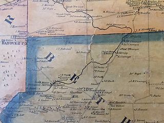
English: Portion of map of Northamption County, Pennsylvania publiahed in 1860 by Smith and Gallup Company of Philadelphia showing parts of Bethlehem and Lower Nazareth Townships and the Monocacy Creek |
| Date | |
| Source | Map of Northampton County, Pennsylvania (1860) |
| Author | Smith, Gallup and Co., Publishers |
Licensing
[edit]
|
This work is in the public domain in its country of origin and other countries and areas where the copyright term is the author's life plus 70 years or fewer. This work is in the public domain in the United States because it was published (or registered with the U.S. Copyright Office) before January 1, 1929. | |
| This file has been identified as being free of known restrictions under copyright law, including all related and neighboring rights. | |
File history
Click on a date/time to view the file as it appeared at that time.
| Date/Time | Thumbnail | Dimensions | User | Comment | |
|---|---|---|---|---|---|
| current | 05:30, 29 November 2014 | | 1,083 × 811 (259 KB) | Jmarquette (talk | contribs) | User created page with UploadWizard |
You cannot overwrite this file.
File usage on Commons
There are no pages that use this file.
File usage on other wikis
The following other wikis use this file:
- Usage on en.wikipedia.org